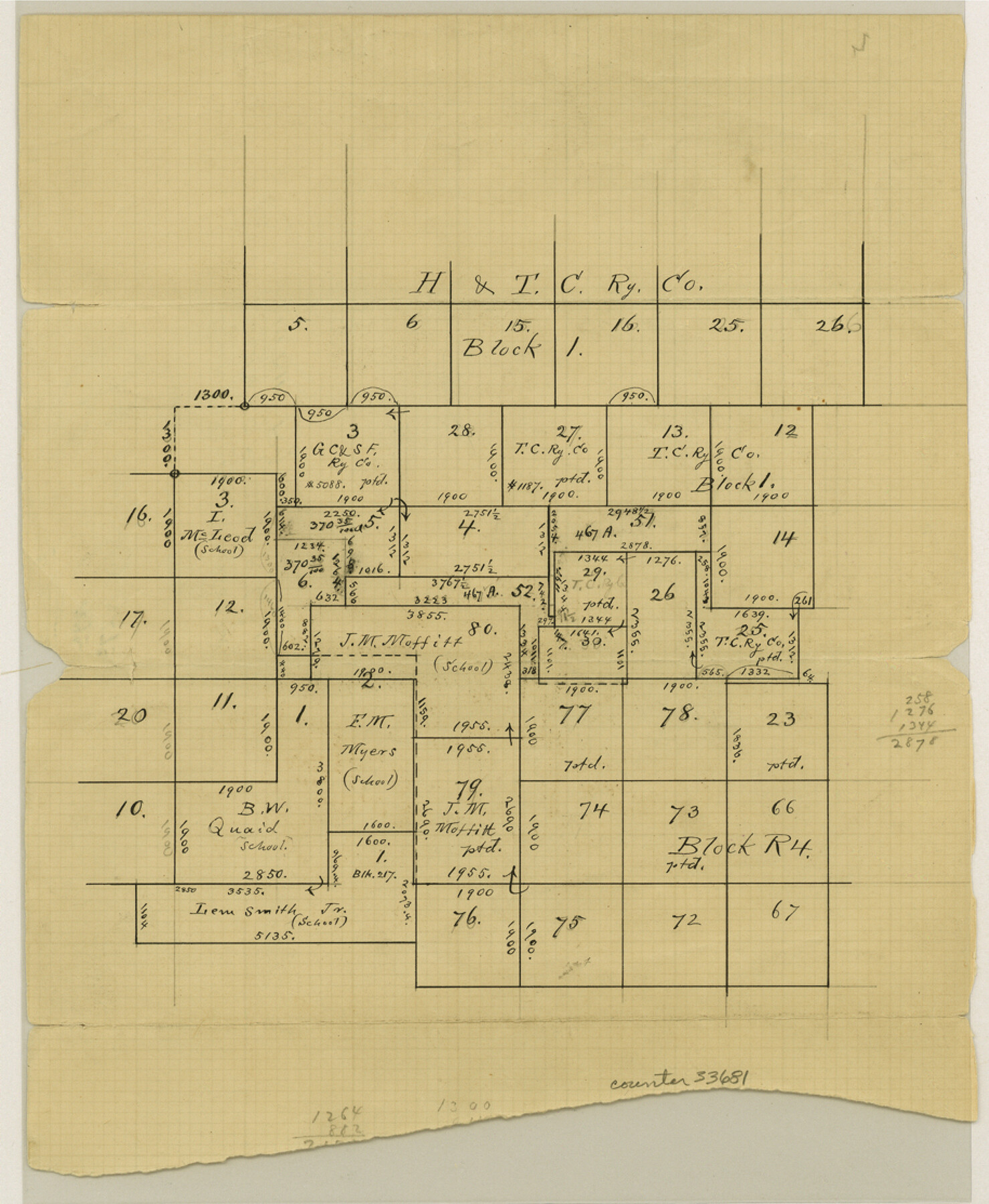
Pecos County Sketch File 27c
[Office sketch in H. & T. C. RR. Co. Block 1 and Block R4]
-
Map/Doc
33681
-
Collection
General Map Collection
-
People and Organizations
E. von Rosenberg (Draftsman)
-
Counties
Pecos
-
Subjects
Surveying Sketch File
-
Height x Width
11.1 x 9.1 inches
28.2 x 23.1 cm
-
Medium
paper, manuscript
Part of: General Map Collection
Flight Mission No. DIX-8P, Frame 88, Aransas County

Print $20.00
- Digital $50.00
Flight Mission No. DIX-8P, Frame 88, Aransas County
1956
Size 18.6 x 22.3 inches
Map/Doc 83913
Cameron County Sketch File 13

Print $50.00
- Digital $50.00
Cameron County Sketch File 13
Size 11.0 x 8.5 inches
Map/Doc 17298
United States - Gulf Coast - From Latitude 26° 33' to the Rio Grande Texas

Print $20.00
- Digital $50.00
United States - Gulf Coast - From Latitude 26° 33' to the Rio Grande Texas
1919
Size 27.5 x 18.4 inches
Map/Doc 72854
Gray County Boundary File 6

Print $6.00
- Digital $50.00
Gray County Boundary File 6
Size 10.9 x 7.3 inches
Map/Doc 53895
Menard County Rolled Sketch 2

Print $20.00
- Digital $50.00
Menard County Rolled Sketch 2
1883
Size 25.0 x 19.9 inches
Map/Doc 6752
North end of Brazos Island

Print $20.00
- Digital $50.00
North end of Brazos Island
Size 25.9 x 18.2 inches
Map/Doc 72917
Map of Asia engraved to illustrate Mitchell's school and family geography (Inset: Map of Palestine or the Holy Land)

Print $20.00
- Digital $50.00
Map of Asia engraved to illustrate Mitchell's school and family geography (Inset: Map of Palestine or the Holy Land)
1839
Size 9.5 x 11.8 inches
Map/Doc 93506
Midland County Working Sketch 28

Print $20.00
- Digital $50.00
Midland County Working Sketch 28
1968
Size 29.7 x 31.7 inches
Map/Doc 71009
Atascosa County Working Sketch 21

Print $20.00
- Digital $50.00
Atascosa County Working Sketch 21
1954
Size 26.0 x 22.4 inches
Map/Doc 67217
Mitchell County Sketch File X

Print $20.00
- Digital $50.00
Mitchell County Sketch File X
1908
Size 29.9 x 17.7 inches
Map/Doc 12104
Flight Mission No. CGI-3N, Frame 186, Cameron County

Print $20.00
- Digital $50.00
Flight Mission No. CGI-3N, Frame 186, Cameron County
1954
Size 18.6 x 22.3 inches
Map/Doc 84650
Blanco County Rolled Sketch 11

Print $6.00
- Digital $50.00
Blanco County Rolled Sketch 11
Size 33.2 x 27.8 inches
Map/Doc 5147
You may also like
Flight Mission No. BQR-12K, Frame 47, Brazoria County

Print $20.00
- Digital $50.00
Flight Mission No. BQR-12K, Frame 47, Brazoria County
1952
Size 18.7 x 22.4 inches
Map/Doc 84062
Hopkins County Sketch File 16a

Print $4.00
- Digital $50.00
Hopkins County Sketch File 16a
Size 12.1 x 7.6 inches
Map/Doc 26715
Sketch of coast of Texas, Laguna Madre from Pt. of Rocks to Corpus Christi [and accompanying letter]
![72962, Sketch of coast of Texas, Laguna Madre from Pt. of Rocks to Corpus Christi [and accompanying letter], General Map Collection](https://historictexasmaps.com/wmedia_w700/maps/72962.tif.jpg)
Print $20.00
- Digital $50.00
Sketch of coast of Texas, Laguna Madre from Pt. of Rocks to Corpus Christi [and accompanying letter]
1881
Size 26.5 x 18.3 inches
Map/Doc 72962
Maverick County Working Sketch 11

Print $20.00
- Digital $50.00
Maverick County Working Sketch 11
1965
Size 41.4 x 35.8 inches
Map/Doc 70903
[Surveys in Williamson County]
![78376, [Surveys in Williamson County], General Map Collection](https://historictexasmaps.com/wmedia_w700/maps/78376.tif.jpg)
Print $2.00
- Digital $50.00
[Surveys in Williamson County]
1847
Size 12.6 x 8.3 inches
Map/Doc 78376
Bosque County Sketch File 10

Print $4.00
- Digital $50.00
Bosque County Sketch File 10
1859
Size 12.9 x 8.2 inches
Map/Doc 14757
Kansas Pacific Railway: The Best and Shortest Cattle Route from Texas

Print $20.00
Kansas Pacific Railway: The Best and Shortest Cattle Route from Texas
1872
Size 21.4 x 16.3 inches
Map/Doc 94453
Hunt County Sketch File 36a

Print $6.00
- Digital $50.00
Hunt County Sketch File 36a
Size 10.5 x 11.5 inches
Map/Doc 27153
[West half of county, south of John H. Stephens Block S2]
![92976, [West half of county, south of John H. Stephens Block S2], Twichell Survey Records](https://historictexasmaps.com/wmedia_w700/maps/92976-1.tif.jpg)
Print $2.00
- Digital $50.00
[West half of county, south of John H. Stephens Block S2]
1912
Size 8.6 x 5.9 inches
Map/Doc 92976
Hunt County Boundary File 11

Print $14.00
- Digital $50.00
Hunt County Boundary File 11
Size 11.3 x 8.9 inches
Map/Doc 55266
Andrews County Working Sketch 7

Print $20.00
- Digital $50.00
Andrews County Working Sketch 7
1954
Size 16.0 x 24.2 inches
Map/Doc 67053
Baylor County Boundary File 10

Print $38.00
- Digital $50.00
Baylor County Boundary File 10
Size 9.4 x 7.7 inches
Map/Doc 50409