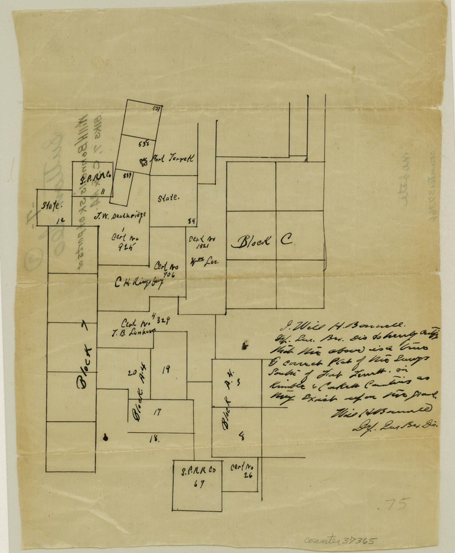
Sutton County Sketch File 7
[Sketch of parts of Blocks 7, C and A4]
-
Map/Doc
37365
-
Collection
General Map Collection
-
People and Organizations
Will H. Bonnell (Surveyor/Engineer)
-
Counties
Sutton
-
Subjects
Surveying Sketch File
-
Height x Width
10.6 x 8.7 inches
26.9 x 22.1 cm
-
Medium
paper, manuscript
Part of: General Map Collection
Hudspeth County Working Sketch 14

Print $20.00
- Digital $50.00
Hudspeth County Working Sketch 14
1953
Size 24.2 x 41.2 inches
Map/Doc 66296
Flight Mission No. DQO-1K, Frame 41, Galveston County

Print $20.00
- Digital $50.00
Flight Mission No. DQO-1K, Frame 41, Galveston County
1952
Size 18.8 x 22.5 inches
Map/Doc 84984
Anderson County Sketch File 16b

Print $2.00
- Digital $50.00
Anderson County Sketch File 16b
1859
Size 7.2 x 2.9 inches
Map/Doc 12788
Flight Mission No. DQO-7K, Frame 100, Galveston County

Print $20.00
- Digital $50.00
Flight Mission No. DQO-7K, Frame 100, Galveston County
1952
Size 18.6 x 22.7 inches
Map/Doc 85115
Pecos County Working Sketch 5

Print $20.00
- Digital $50.00
Pecos County Working Sketch 5
1886
Size 22.8 x 19.2 inches
Map/Doc 71475
Baylor County Sketch File A4

Print $8.00
- Digital $50.00
Baylor County Sketch File A4
Size 14.0 x 8.7 inches
Map/Doc 14084
Mitchell County Sketch File 14

Print $20.00
- Digital $50.00
Mitchell County Sketch File 14
1930
Size 17.5 x 20.5 inches
Map/Doc 12101
El Paso County Sketch File 28

Print $18.00
- Digital $50.00
El Paso County Sketch File 28
1939
Size 15.2 x 9.5 inches
Map/Doc 22070
Glasscock County Rolled Sketch 12

Print $20.00
- Digital $50.00
Glasscock County Rolled Sketch 12
1957
Size 19.6 x 16.1 inches
Map/Doc 6018
Wharton County Sketch File 2

Print $40.00
- Digital $50.00
Wharton County Sketch File 2
1875
Size 13.6 x 12.6 inches
Map/Doc 39913
Coryell County Boundary File 3

Print $14.00
- Digital $50.00
Coryell County Boundary File 3
Size 13.2 x 8.2 inches
Map/Doc 51907
Reagan County Sketch File 3

Print $20.00
- Digital $50.00
Reagan County Sketch File 3
Size 18.0 x 21.9 inches
Map/Doc 12213
You may also like
Gaines County Rolled Sketch 24

Print $20.00
- Digital $50.00
Gaines County Rolled Sketch 24
1965
Size 41.8 x 31.3 inches
Map/Doc 9314

[Santa Rosa Leagues, Brooks & Kenedy Counties, Texas]
![10774, [Santa Rosa Leagues, Brooks & Kenedy Counties, Texas], Maddox Collection](https://historictexasmaps.com/wmedia_w700/maps/10774.tif.jpg)
Print $20.00
- Digital $50.00
[Santa Rosa Leagues, Brooks & Kenedy Counties, Texas]
Size 21.0 x 24.6 inches
Map/Doc 10774
Kerr County Sketch File 25

Print $4.00
- Digital $50.00
Kerr County Sketch File 25
1873
Size 10.0 x 8.0 inches
Map/Doc 28905
D No. 5 - Reconnaissance of Hatteras Inlet, North Carolina

Print $20.00
- Digital $50.00
D No. 5 - Reconnaissance of Hatteras Inlet, North Carolina
1853
Size 17.1 x 14.9 inches
Map/Doc 97212
Flight Mission No. CGI-1N, Frame 178, Cameron County

Print $20.00
- Digital $50.00
Flight Mission No. CGI-1N, Frame 178, Cameron County
1955
Size 18.6 x 22.3 inches
Map/Doc 84513
Gulf Intracoastal Waterway - Aransas Bay to Corpus Christi Bay, Modified Route of Main Channel Location of Spoil Disposal Areas

Print $20.00
- Digital $50.00
Gulf Intracoastal Waterway - Aransas Bay to Corpus Christi Bay, Modified Route of Main Channel Location of Spoil Disposal Areas
1961
Size 31.4 x 42.1 inches
Map/Doc 61829
Hudspeth County Rolled Sketch 59

Print $40.00
- Digital $50.00
Hudspeth County Rolled Sketch 59
Size 69.2 x 42.8 inches
Map/Doc 9224
The Texas and Oklahoma Official Railway and Hotel Guide Map

Print $20.00
The Texas and Oklahoma Official Railway and Hotel Guide Map
1906
Size 23.5 x 23.4 inches
Map/Doc 79316
Angelina County Sketch File 15

Print $8.00
- Digital $50.00
Angelina County Sketch File 15
1848
Size 12.5 x 7.5 inches
Map/Doc 12960
Arroyo Colorado, La Feria Sheet

Print $40.00
- Digital $50.00
Arroyo Colorado, La Feria Sheet
1929
Size 24.6 x 58.5 inches
Map/Doc 65128
El Paso County Sketch File 21

Print $35.00
- Digital $50.00
El Paso County Sketch File 21
1916
Size 14.5 x 9.1 inches
Map/Doc 22014