Anderson County Sketch File 16b
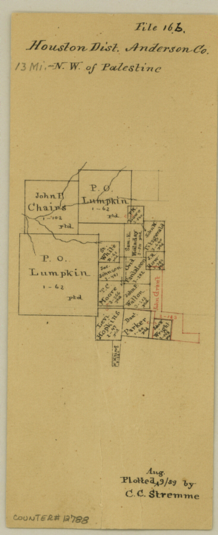
[Office sketch of Lumpkin surveys and surrounding area in northwest part of county]
-
Map/Doc
12788
-
Collection
General Map Collection
-
Object Dates
1859/8/9 (Creation Date)
-
People and Organizations
C.C. Stremme (Draftsman)
-
Counties
Anderson
-
Subjects
Surveying Sketch File
-
Height x Width
7.2 x 2.9 inches
18.3 x 7.4 cm
-
Medium
paper, manuscript
Part of: General Map Collection
Flight Mission No. BRE-2P, Frame 17, Nueces County

Print $20.00
- Digital $50.00
Flight Mission No. BRE-2P, Frame 17, Nueces County
1956
Size 18.2 x 22.1 inches
Map/Doc 86726
Edwards County Sketch File A13

Print $20.00
- Digital $50.00
Edwards County Sketch File A13
1901
Size 22.8 x 46.6 inches
Map/Doc 10444
Fort Bend County State Real Property Sketch 9

Print $40.00
- Digital $50.00
Fort Bend County State Real Property Sketch 9
1986
Size 34.7 x 43.2 inches
Map/Doc 61683
Brewster County Rolled Sketch 124

Print $20.00
- Digital $50.00
Brewster County Rolled Sketch 124
1975
Size 15.8 x 13.2 inches
Map/Doc 5299
Aransas County Rolled Sketch 29

Print $20.00
- Digital $50.00
Aransas County Rolled Sketch 29
1961
Size 35.8 x 31.1 inches
Map/Doc 77497
Brazos River, Gurley Sheet

Print $6.00
- Digital $50.00
Brazos River, Gurley Sheet
1929
Size 33.1 x 30.2 inches
Map/Doc 65282
Refugio County Sketch File 17a

Print $2.00
- Digital $50.00
Refugio County Sketch File 17a
1916
Size 11.4 x 9.0 inches
Map/Doc 35275
Jeff Davis County Boundary File 1

Print $18.00
- Digital $50.00
Jeff Davis County Boundary File 1
Size 8.8 x 8.6 inches
Map/Doc 55492
Zapata County Sketch File 13b

Print $6.00
- Digital $50.00
Zapata County Sketch File 13b
1936
Size 11.4 x 8.9 inches
Map/Doc 40954
Presidio County Rolled Sketch 84

Print $20.00
- Digital $50.00
Presidio County Rolled Sketch 84
1942
Size 22.7 x 33.1 inches
Map/Doc 9779
San Patricio County Sketch File 22

Print $20.00
San Patricio County Sketch File 22
1918
Size 22.2 x 16.9 inches
Map/Doc 12285
Flight Mission No. BQR-4K, Frame 67, Brazoria County

Print $20.00
- Digital $50.00
Flight Mission No. BQR-4K, Frame 67, Brazoria County
1952
Size 18.7 x 22.5 inches
Map/Doc 84000
You may also like
Caldwell County

Print $20.00
- Digital $50.00
Caldwell County
1935
Size 37.8 x 42.0 inches
Map/Doc 73095
Fisher County Working Sketch 14

Print $20.00
- Digital $50.00
Fisher County Working Sketch 14
1957
Size 24.9 x 33.1 inches
Map/Doc 69148
Navigation Maps of Gulf Intracoastal Waterway, Port Arthur to Brownsville, Texas

Print $4.00
- Digital $50.00
Navigation Maps of Gulf Intracoastal Waterway, Port Arthur to Brownsville, Texas
1951
Size 16.8 x 21.6 inches
Map/Doc 65419
Shelby County Working Sketch 4

Print $20.00
- Digital $50.00
Shelby County Working Sketch 4
1941
Size 32.3 x 41.8 inches
Map/Doc 63857
Motley County Working Sketch 8

Print $20.00
- Digital $50.00
Motley County Working Sketch 8
1983
Size 32.1 x 30.6 inches
Map/Doc 71213
North Shore of West Bay and Galveston Island

Print $40.00
- Digital $50.00
North Shore of West Bay and Galveston Island
1933
Size 37.4 x 57.7 inches
Map/Doc 69930
Fisher County Rolled Sketch Y

Print $20.00
- Digital $50.00
Fisher County Rolled Sketch Y
Size 42.1 x 25.4 inches
Map/Doc 5878
Comanche County, Texas

Print $20.00
- Digital $50.00
Comanche County, Texas
1879
Size 23.5 x 28.4 inches
Map/Doc 702
Reagan County Sketch File 22

Print $6.00
- Digital $50.00
Reagan County Sketch File 22
1939
Size 11.4 x 8.9 inches
Map/Doc 35013
General Highway Map, Dickens County, Texas

Print $20.00
General Highway Map, Dickens County, Texas
1940
Size 18.3 x 25.3 inches
Map/Doc 79076
Gaines County Working Sketch 27

Print $20.00
- Digital $50.00
Gaines County Working Sketch 27
Size 17.4 x 36.7 inches
Map/Doc 69327
Flight Mission No. DAG-23K, Frame 18, Matagorda County

Print $20.00
- Digital $50.00
Flight Mission No. DAG-23K, Frame 18, Matagorda County
1953
Size 18.5 x 22.2 inches
Map/Doc 86480