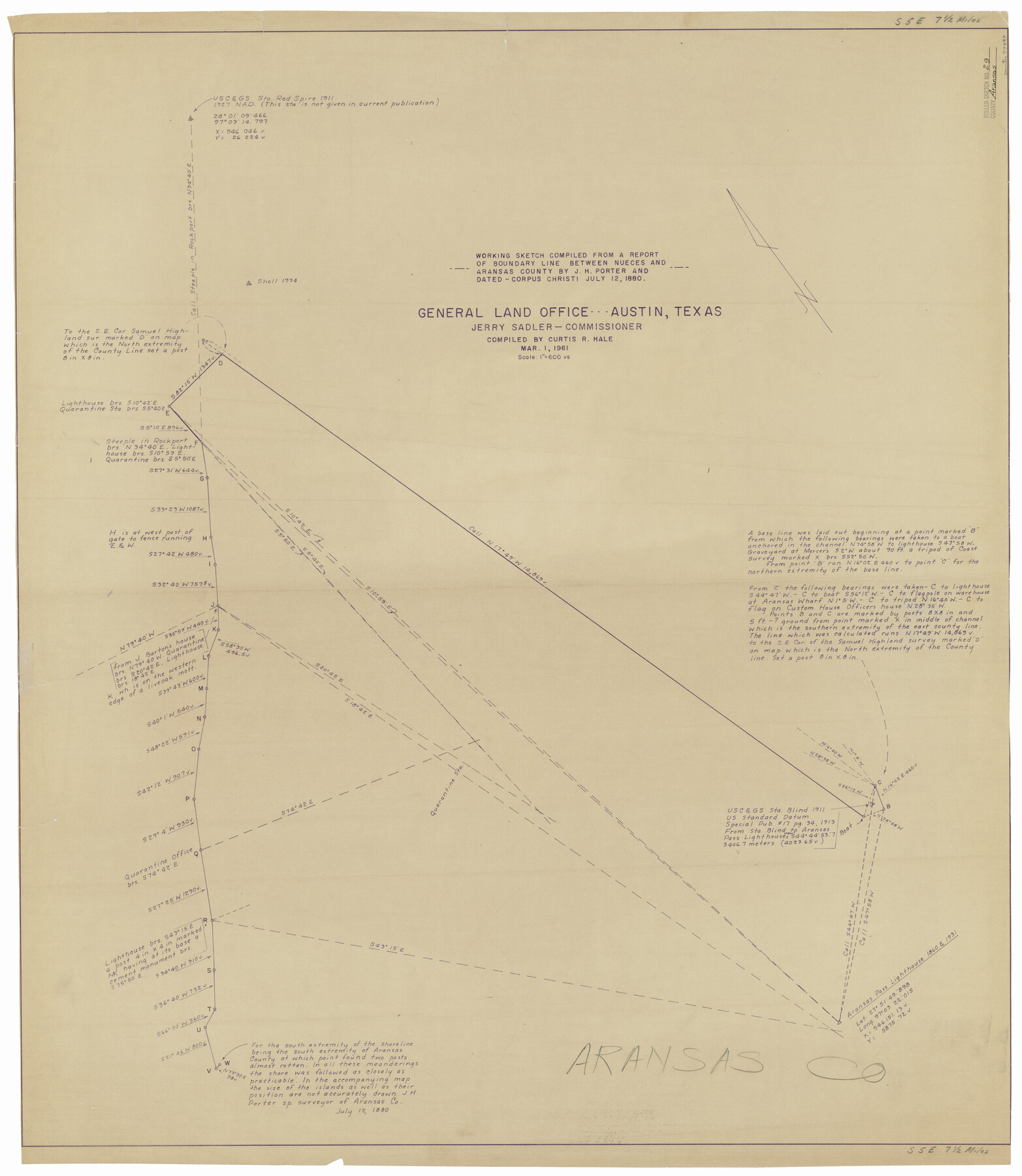
Aransas County Rolled Sketch 29
Working Sketch compiled from a report of boundary line between Nueces and Aransas County by J.H. Porter and dated Corpus Christi, July 12, 1880
-
Map/Doc
77497
-
Collection
General Map Collection
-
Object Dates
1961/3/1 (Creation Date)
-
People and Organizations
J.H. Porter (Surveyor/Engineer)
Curtis R. Hale (Compiler)
-
Counties
Aransas
-
Subjects
Surveying Rolled Sketch
-
Height x Width
35.8 x 31.1 inches
90.9 x 79.0 cm
-
Medium
blueprint/diazo
-
Scale
1" = 600 varas
Part of: General Map Collection
Bosque County Working Sketch 7

Print $20.00
- Digital $50.00
Bosque County Working Sketch 7
1942
Size 23.7 x 34.5 inches
Map/Doc 67440
Brooks County Working Sketch 6

Print $20.00
- Digital $50.00
Brooks County Working Sketch 6
1917
Size 28.6 x 15.7 inches
Map/Doc 67790
Lynn County Rolled Sketch A

Print $20.00
- Digital $50.00
Lynn County Rolled Sketch A
1901
Size 33.5 x 34.2 inches
Map/Doc 9471
Bandera County Rolled Sketch 4

Print $20.00
- Digital $50.00
Bandera County Rolled Sketch 4
1963
Size 36.0 x 28.5 inches
Map/Doc 5116
Howard County Rolled Sketch 8

Print $20.00
- Digital $50.00
Howard County Rolled Sketch 8
Size 16.8 x 40.2 inches
Map/Doc 6237
Angelina County Sketch File 28a

Print $14.00
- Digital $50.00
Angelina County Sketch File 28a
1910
Size 6.8 x 8.7 inches
Map/Doc 13080
Webb County Sketch File 45

Print $20.00
- Digital $50.00
Webb County Sketch File 45
1883
Size 17.5 x 22.5 inches
Map/Doc 12642
Wise County Sketch File 52

Print $20.00
- Digital $50.00
Wise County Sketch File 52
1982
Size 14.2 x 8.6 inches
Map/Doc 40619
Kinney County Working Sketch 34

Print $20.00
- Digital $50.00
Kinney County Working Sketch 34
1963
Size 23.0 x 26.9 inches
Map/Doc 70216
Brazoria County NRC Article 33.136 Sketch 4

Print $22.00
- Digital $50.00
Brazoria County NRC Article 33.136 Sketch 4
2003
Size 24.3 x 35.8 inches
Map/Doc 80120
Flight Mission No. CGI-4N, Frame 186, Cameron County

Print $20.00
- Digital $50.00
Flight Mission No. CGI-4N, Frame 186, Cameron County
1955
Size 18.5 x 22.2 inches
Map/Doc 84689
Comal County Working Sketch 19

Print $20.00
- Digital $50.00
Comal County Working Sketch 19
2006
Size 18.8 x 29.0 inches
Map/Doc 83094
You may also like
San Patricio County Sketch File 25

Print $4.00
San Patricio County Sketch File 25
1875
Size 10.8 x 7.0 inches
Map/Doc 36083
Midland County

Print $20.00
- Digital $50.00
Midland County
1930
Size 45.9 x 39.5 inches
Map/Doc 95589
Bosque County Sketch File 22

Print $4.00
- Digital $50.00
Bosque County Sketch File 22
1863
Size 13.8 x 8.5 inches
Map/Doc 14804
Flight Mission No. CRK-3P, Frame 178, Refugio County

Print $20.00
- Digital $50.00
Flight Mission No. CRK-3P, Frame 178, Refugio County
1956
Size 18.4 x 22.2 inches
Map/Doc 86925
Flight Mission No. DAH-17M, Frame 25, Orange County

Print $20.00
- Digital $50.00
Flight Mission No. DAH-17M, Frame 25, Orange County
1953
Size 18.7 x 22.3 inches
Map/Doc 86888
Map of the Fort Worth and Denver City RR., Oldham Co, Texas

Print $40.00
- Digital $50.00
Map of the Fort Worth and Denver City RR., Oldham Co, Texas
1899
Size 117.7 x 20.6 inches
Map/Doc 93183
[Surveys along the Frio River]
![129, [Surveys along the Frio River], General Map Collection](https://historictexasmaps.com/wmedia_w700/maps/129.tif.jpg)
Print $20.00
- Digital $50.00
[Surveys along the Frio River]
1841
Size 12.0 x 16.6 inches
Map/Doc 129
Wheeler County Working Sketch Graphic Index

Print $20.00
- Digital $50.00
Wheeler County Working Sketch Graphic Index
1899
Size 41.4 x 36.8 inches
Map/Doc 76738
[R. M. Thompson Block T2 and John H. Stephens Block S2 Conflict]
![91056, [R. M. Thompson Block T2 and John H. Stephens Block S2 Conflict], Twichell Survey Records](https://historictexasmaps.com/wmedia_w700/maps/91056-1.tif.jpg)
Print $20.00
- Digital $50.00
[R. M. Thompson Block T2 and John H. Stephens Block S2 Conflict]
Size 20.9 x 30.6 inches
Map/Doc 91056
Somervell County Sketch File 4

Print $4.00
- Digital $50.00
Somervell County Sketch File 4
Size 6.4 x 8.8 inches
Map/Doc 36800
General Highway Map, Pecos County, Texas

Print $20.00
General Highway Map, Pecos County, Texas
1940
Size 24.7 x 18.1 inches
Map/Doc 79218
Kerr County State Real Property Sketch 2

Print $2.00
- Digital $50.00
Kerr County State Real Property Sketch 2
2007
Size 10.7 x 8.6 inches
Map/Doc 88675