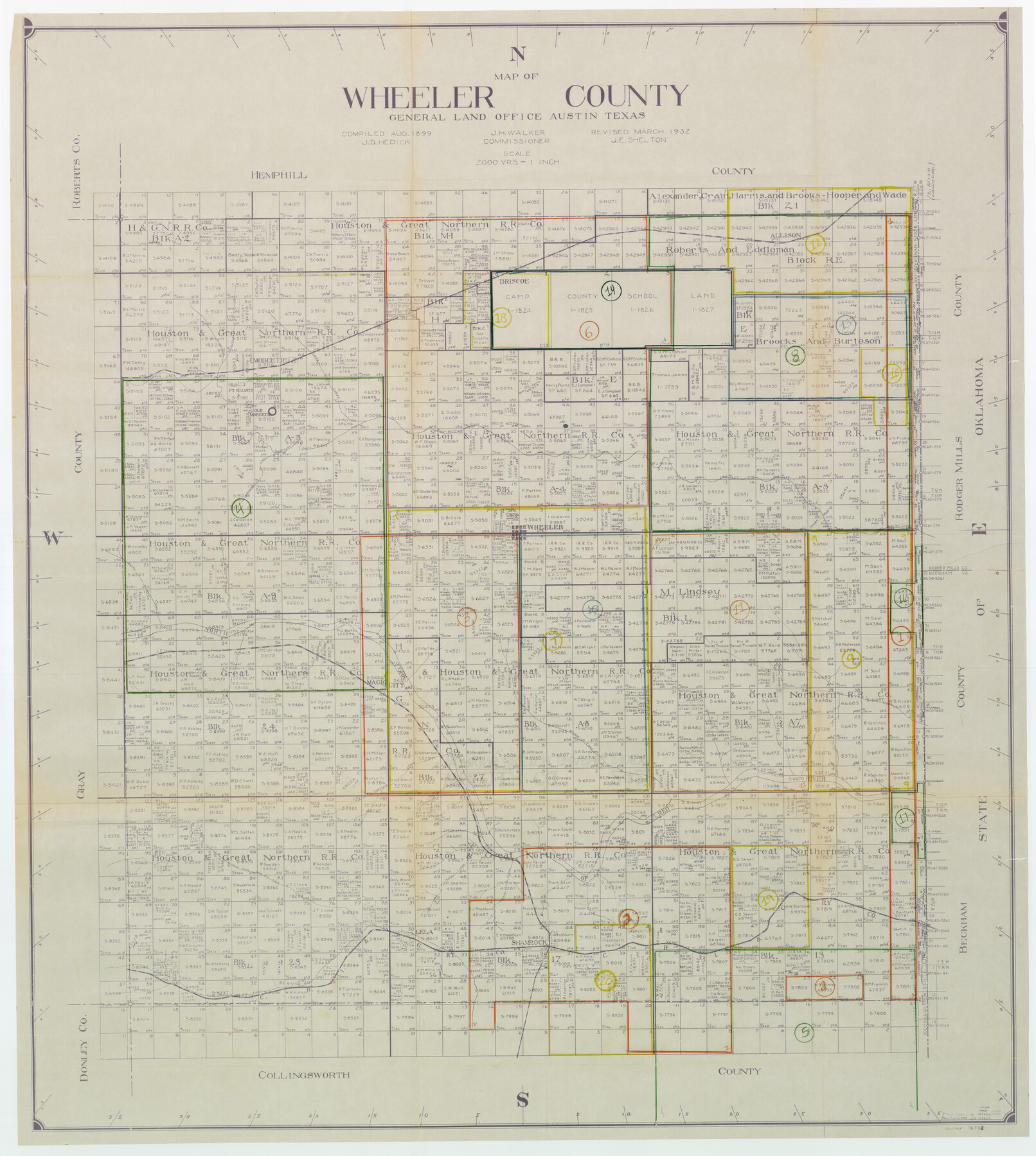
Wheeler County Working Sketch Graphic Index
-
Map/Doc
76738
-
Collection
General Map Collection
-
Object Dates
8/1899 (Creation Date)
3/1932 (Revision Date)
-
People and Organizations
J.D. Hedick (Compiler)
J.E. Shelton (Draftsman)
-
Counties
Wheeler
-
Subjects
County Surveying Working Sketch
-
Height x Width
41.4 x 36.8 inches
105.2 x 93.5 cm
-
Scale
1" = 2000 varas
Part of: General Map Collection
La Salle County Boundary File 1

Print $24.00
- Digital $50.00
La Salle County Boundary File 1
Size 8.7 x 14.2 inches
Map/Doc 56239
Edwards County Working Sketch 66

Print $20.00
- Digital $50.00
Edwards County Working Sketch 66
1957
Size 24.1 x 17.3 inches
Map/Doc 68942
Kent County Rolled Sketch 4

Print $20.00
- Digital $50.00
Kent County Rolled Sketch 4
1950
Size 22.1 x 31.1 inches
Map/Doc 6475
[Galveston, Harrisburg & San Antonio from El Paso-Presidio county boundary to Presidio-Pecos county boundary]
![64718, [Galveston, Harrisburg & San Antonio from El Paso-Presidio county boundary to Presidio-Pecos county boundary], General Map Collection](https://historictexasmaps.com/wmedia_w700/maps/64718.tif.jpg)
Print $40.00
- Digital $50.00
[Galveston, Harrisburg & San Antonio from El Paso-Presidio county boundary to Presidio-Pecos county boundary]
Size 106.1 x 44.3 inches
Map/Doc 64718
Maverick County Sketch File 10a

Print $19.00
- Digital $50.00
Maverick County Sketch File 10a
1878
Size 15.4 x 10.0 inches
Map/Doc 31083
Panola County Working Sketch 14

Print $40.00
- Digital $50.00
Panola County Working Sketch 14
1945
Map/Doc 71423
Dickens County Sketch File 8

Print $4.00
- Digital $50.00
Dickens County Sketch File 8
Size 8.8 x 14.2 inches
Map/Doc 20971
Lynn County Rolled Sketch 13

Print $20.00
- Digital $50.00
Lynn County Rolled Sketch 13
Size 36.2 x 24.7 inches
Map/Doc 6649
Webb County Rolled Sketch 79

Print $20.00
- Digital $50.00
Webb County Rolled Sketch 79
2020
Size 35.7 x 24.9 inches
Map/Doc 95916
[Surveys along Seco Creek]
![268, [Surveys along Seco Creek], General Map Collection](https://historictexasmaps.com/wmedia_w700/maps/268.tif.jpg)
Print $3.00
- Digital $50.00
[Surveys along Seco Creek]
1847
Size 14.6 x 9.8 inches
Map/Doc 268
[Maps of surveys in Reeves & Culberson Cos]
![61134, [Maps of surveys in Reeves & Culberson Cos], General Map Collection](https://historictexasmaps.com/wmedia_w700/maps/61134.tif.jpg)
Print $20.00
- Digital $50.00
[Maps of surveys in Reeves & Culberson Cos]
1937
Size 30.7 x 24.9 inches
Map/Doc 61134
Brazoria County Sketch File 23

Print $40.00
- Digital $50.00
Brazoria County Sketch File 23
Size 12.7 x 12.2 inches
Map/Doc 15020
You may also like
Map of Erath County

Print $20.00
- Digital $50.00
Map of Erath County
1872
Size 20.2 x 19.8 inches
Map/Doc 3521
Galveston County NRC Article 33.136 Sketch 85

Print $42.00
- Digital $50.00
Galveston County NRC Article 33.136 Sketch 85
2015
Size 36.4 x 24.5 inches
Map/Doc 94965
Medina County Rolled Sketch 19

Print $40.00
- Digital $50.00
Medina County Rolled Sketch 19
1987
Size 45.1 x 57.8 inches
Map/Doc 9508
![94158, Austin Street Map [Recto], General Map Collection](https://historictexasmaps.com/wmedia_w700/maps/94158.tif.jpg)
Right of Way & Track Map, St. Louis, Brownsville & Mexico Ry. operated by St. Louis, Brownsville & Mexico Ry. Co.

Print $40.00
- Digital $50.00
Right of Way & Track Map, St. Louis, Brownsville & Mexico Ry. operated by St. Louis, Brownsville & Mexico Ry. Co.
1919
Size 25.7 x 57.6 inches
Map/Doc 64619

Map of Caldwell County, Texas

Print $20.00
Map of Caldwell County, Texas
1879
Size 17.4 x 21.5 inches
Map/Doc 88914
Map of Bexar County

Print $20.00
- Digital $50.00
Map of Bexar County
1845
Size 47.4 x 44.9 inches
Map/Doc 87234
Leon County Sketch File 12

Print $23.00
- Digital $50.00
Leon County Sketch File 12
1886
Size 9.5 x 11.5 inches
Map/Doc 29765
Brooks County Rolled Sketch 11A

Print $20.00
- Digital $50.00
Brooks County Rolled Sketch 11A
1906
Size 18.1 x 24.6 inches
Map/Doc 76060
Henderson County Rolled Sketch 14

Print $20.00
- Digital $50.00
Henderson County Rolled Sketch 14
2012
Size 19.3 x 32.3 inches
Map/Doc 95715
Orange County Rolled Sketch 33

Print $40.00
- Digital $50.00
Orange County Rolled Sketch 33
Size 58.4 x 50.1 inches
Map/Doc 9652