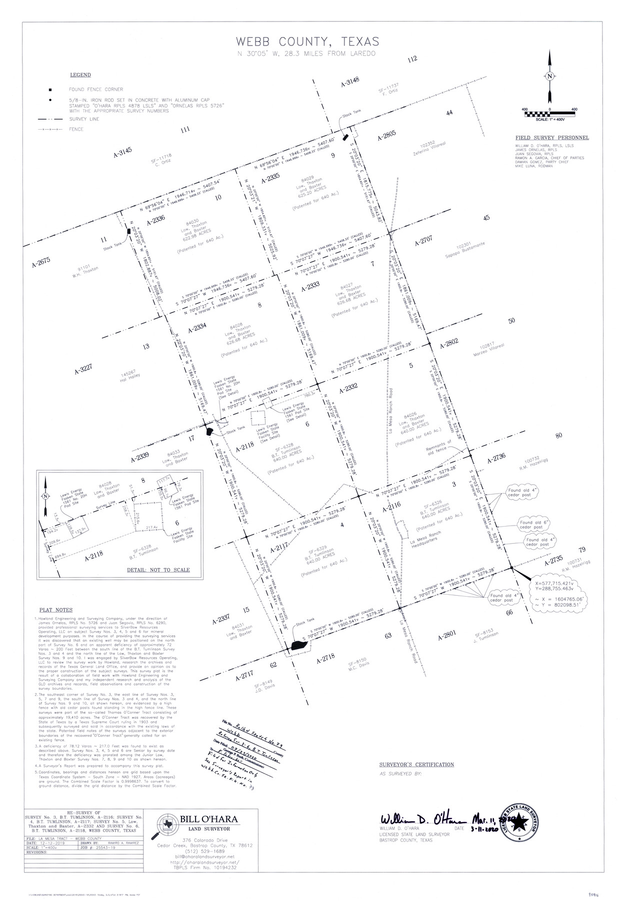
Webb County Rolled Sketch 79
Re-survey of survey no. 3, B.T. Tumlinson, A-2116; survey no. 4, B.T. Tumlinson, A-2117; survey no. 5, Low, Thaxton and Baxter, A-2332 and survey no. 6, B.T. Tumlinson, A-2118
-
Map/Doc
95916
-
Collection
General Map Collection
-
Object Dates
3/11/2020 (Creation Date)
7/29/2020 (File Date)
-
People and Organizations
Bill O'Hara (Surveyor/Engineer)
Ramiro A. Ramirez (Draftsman)
James Ornelas (Chainman/Field Personnel)
Juan Segovia (Chainman/Field Personnel)
Ramon A. Garcia (Chainman/Field Personnel)
Damian Gomez (Chainman/Field Personnel)
Mike Luna (Chainman/Field Personnel)
-
Counties
Webb
-
Subjects
Surveying Rolled Sketch
-
Height x Width
35.7 x 24.9 inches
90.7 x 63.3 cm
-
Medium
mylar, print
-
Scale
1" = 400 varas
-
Comments
Filed for information only. See Webb County Sketch File 73 (95917) for report.
Related maps
Webb County Sketch File 73

Print $20.00
- Digital $50.00
Webb County Sketch File 73
2020
Size 11.0 x 8.5 inches
Map/Doc 95917
Part of: General Map Collection
Flight Mission No. BRA-7M, Frame117, Jefferson County

Print $20.00
- Digital $50.00
Flight Mission No. BRA-7M, Frame117, Jefferson County
1953
Size 18.7 x 22.4 inches
Map/Doc 85511
Presidio County Rolled Sketch 31

Print $40.00
- Digital $50.00
Presidio County Rolled Sketch 31
Size 41.1 x 82.1 inches
Map/Doc 9768
Trinity County Sketch File 3

Print $24.00
- Digital $50.00
Trinity County Sketch File 3
Size 12.6 x 15.0 inches
Map/Doc 38498
Calhoun County Sketch File 20

Print $10.00
Calhoun County Sketch File 20
1839
Size 8.8 x 8.6 inches
Map/Doc 76865
Map of Coryell Co.

Print $40.00
- Digital $50.00
Map of Coryell Co.
1896
Size 48.0 x 46.2 inches
Map/Doc 66786

Briscoe County Sketch File 14

Print $20.00
- Digital $50.00
Briscoe County Sketch File 14
1910
Size 14.2 x 8.5 inches
Map/Doc 16509
Hudspeth County Rolled Sketch 59

Print $40.00
- Digital $50.00
Hudspeth County Rolled Sketch 59
Size 69.2 x 42.8 inches
Map/Doc 9224
Montague County Sketch File 20

Print $42.00
- Digital $50.00
Montague County Sketch File 20
1923
Size 34.6 x 19.8 inches
Map/Doc 12106
Flight Mission No. CUG-1P, Frame 19, Kleberg County

Print $20.00
- Digital $50.00
Flight Mission No. CUG-1P, Frame 19, Kleberg County
1956
Size 18.6 x 22.2 inches
Map/Doc 86109
Hamilton County Sketch File 23

Print $20.00
- Digital $50.00
Hamilton County Sketch File 23
1955
Size 25.8 x 24.8 inches
Map/Doc 11618
Flight Mission No. BQR-4K, Frame 65, Brazoria County

Print $20.00
- Digital $50.00
Flight Mission No. BQR-4K, Frame 65, Brazoria County
1952
Size 18.5 x 22.3 inches
Map/Doc 83998
You may also like
General Highway Map, Coleman County, Texas

Print $20.00
General Highway Map, Coleman County, Texas
1940
Size 18.4 x 25.2 inches
Map/Doc 79051
Flight Mission No. CRE-1R, Frame 63, Jackson County

Print $20.00
- Digital $50.00
Flight Mission No. CRE-1R, Frame 63, Jackson County
1956
Size 18.6 x 18.9 inches
Map/Doc 85326
Flight Mission No. BRA-7M, Frame 188, Jefferson County

Print $20.00
- Digital $50.00
Flight Mission No. BRA-7M, Frame 188, Jefferson County
1953
Size 18.6 x 22.3 inches
Map/Doc 85556
Brewster County Sketch File 44

Print $3.00
- Digital $50.00
Brewster County Sketch File 44
Size 11.5 x 9.4 inches
Map/Doc 16311
Flight Mission No. BRA-8M, Frame 141, Jefferson County

Print $20.00
- Digital $50.00
Flight Mission No. BRA-8M, Frame 141, Jefferson County
1953
Size 18.8 x 22.4 inches
Map/Doc 85633
The Judicial District/County of Menard. Created, January 22, 1841

Print $20.00
The Judicial District/County of Menard. Created, January 22, 1841
2020
Size 22.4 x 21.7 inches
Map/Doc 96335

Val Verde County Sketch File 25

Print $20.00
- Digital $50.00
Val Verde County Sketch File 25
Size 19.8 x 24.6 inches
Map/Doc 12572
Coast Chart No. 212 - From Latitude 26° 33' to the Rio Grande Texas

Print $20.00
- Digital $50.00
Coast Chart No. 212 - From Latitude 26° 33' to the Rio Grande Texas
1886
Size 18.3 x 24.1 inches
Map/Doc 72835
Sterling County Sketch File 11

Print $40.00
- Digital $50.00
Sterling County Sketch File 11
1929
Size 14.2 x 17.2 inches
Map/Doc 37148
Webb County Working Sketch 13

Print $20.00
- Digital $50.00
Webb County Working Sketch 13
1922
Size 14.6 x 11.4 inches
Map/Doc 72378
Edwards County

Print $20.00
- Digital $50.00
Edwards County
1893
Size 30.8 x 33.1 inches
Map/Doc 3507