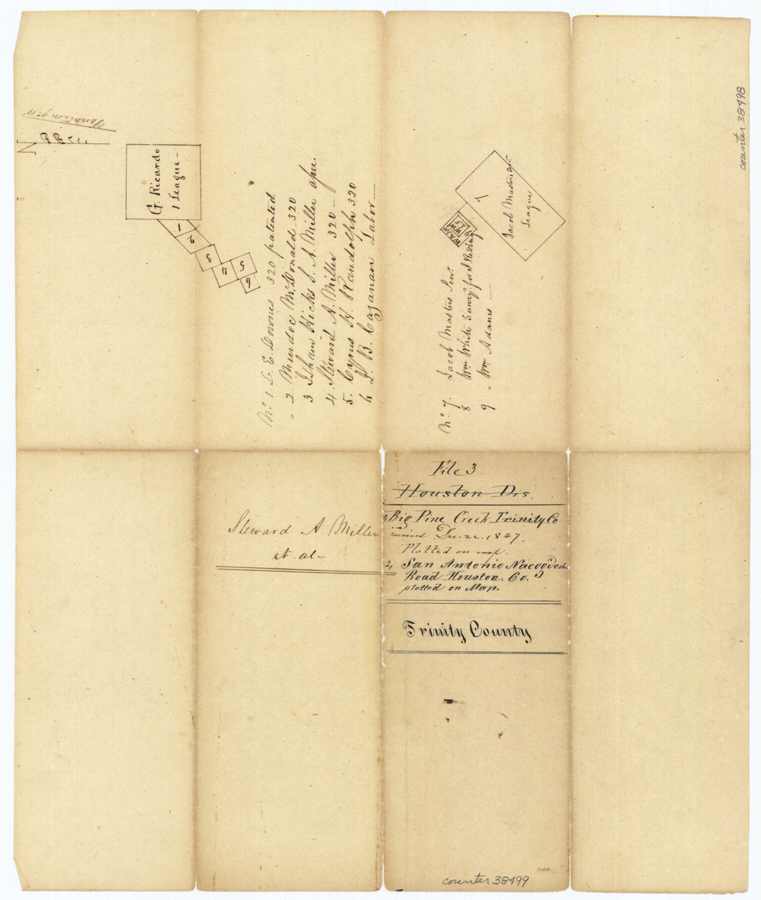
Trinity County Sketch File 3
[Sketches of G. Ricardo league and Jacob Masters Sr. league]
-
Map/Doc
38498
-
Collection
General Map Collection
-
Object Dates
12/22/1847 (File Date)
-
People and Organizations
W.M. James (Surveyor/Engineer)
-
Counties
Trinity
-
Subjects
Surveying Sketch File
-
Height x Width
12.6 x 15.0 inches
32.0 x 38.1 cm
-
Medium
paper, manuscript
-
Features
Big Pine Creek
San Antonio-Nacogdoches Road
Part of: General Map Collection
Palo Pinto County Working Sketch Graphic Index

Print $20.00
- Digital $50.00
Palo Pinto County Working Sketch Graphic Index
1941
Map/Doc 76659
El Paso County Working Sketch 50

Print $20.00
- Digital $50.00
El Paso County Working Sketch 50
1991
Size 25.9 x 27.7 inches
Map/Doc 69072
Real County Working Sketch 90

Print $20.00
- Digital $50.00
Real County Working Sketch 90
1991
Size 16.7 x 22.8 inches
Map/Doc 71982
Flight Mission No. CUG-3P, Frame 36, Kleberg County

Print $20.00
- Digital $50.00
Flight Mission No. CUG-3P, Frame 36, Kleberg County
1956
Size 18.4 x 22.1 inches
Map/Doc 86241
San Jacinto River and Tributaries, Texas - Survey of 1939

Print $20.00
- Digital $50.00
San Jacinto River and Tributaries, Texas - Survey of 1939
1939
Size 27.7 x 40.5 inches
Map/Doc 60310
Wheeler County Working Sketch 7

Print $40.00
- Digital $50.00
Wheeler County Working Sketch 7
1972
Size 50.1 x 42.9 inches
Map/Doc 72496
Panola County Working Sketch 38

Print $20.00
- Digital $50.00
Panola County Working Sketch 38
1991
Map/Doc 71447
Harris County Sketch File 31a

Print $20.00
- Digital $50.00
Harris County Sketch File 31a
1895
Size 12.8 x 21.9 inches
Map/Doc 11650
Camp County Sketch File 1

Print $4.00
- Digital $50.00
Camp County Sketch File 1
Size 10.4 x 8.1 inches
Map/Doc 17333
Culberson County Working Sketch 73

Print $40.00
- Digital $50.00
Culberson County Working Sketch 73
1975
Size 48.7 x 33.4 inches
Map/Doc 68527
[Galveston, Harrisburg & San Antonio Railway]
![64408, [Galveston, Harrisburg & San Antonio Railway], General Map Collection](https://historictexasmaps.com/wmedia_w700/maps/64408.tif.jpg)
Print $20.00
- Digital $50.00
[Galveston, Harrisburg & San Antonio Railway]
1892
Size 13.5 x 33.6 inches
Map/Doc 64408
Parker County Sketch File 42

Print $114.00
- Digital $50.00
Parker County Sketch File 42
1877
Size 14.4 x 12.0 inches
Map/Doc 33589
You may also like
McLennan County Working Sketch 9

Print $20.00
- Digital $50.00
McLennan County Working Sketch 9
2008
Size 23.0 x 28.9 inches
Map/Doc 88768
Reagan County Sketch File RB

Print $8.00
- Digital $50.00
Reagan County Sketch File RB
Size 11.3 x 9.0 inches
Map/Doc 34996
Briscoe County Working Sketch 9

Print $20.00
- Digital $50.00
Briscoe County Working Sketch 9
1951
Size 24.9 x 36.7 inches
Map/Doc 67812
[Showing west and north line of County]
![90652, [Showing west and north line of County], Twichell Survey Records](https://historictexasmaps.com/wmedia_w700/maps/90652-1.tif.jpg)
Print $20.00
- Digital $50.00
[Showing west and north line of County]
1885
Size 21.3 x 29.0 inches
Map/Doc 90652
Portion of Pecos County

Print $20.00
- Digital $50.00
Portion of Pecos County
Size 18.8 x 21.6 inches
Map/Doc 91589
Kinney County Sketch File 11

Print $20.00
- Digital $50.00
Kinney County Sketch File 11
1885
Size 28.3 x 18.1 inches
Map/Doc 11939
Galveston Bay Entrance - Galveston and Texas City Harbors

Print $40.00
- Digital $50.00
Galveston Bay Entrance - Galveston and Texas City Harbors
1992
Size 37.1 x 55.6 inches
Map/Doc 69866
Henderson County Sketch File 13

Print $4.00
- Digital $50.00
Henderson County Sketch File 13
1876
Size 8.2 x 12.8 inches
Map/Doc 26353
Pecos County Sketch File 89

Print $40.00
- Digital $50.00
Pecos County Sketch File 89
1949
Size 15.2 x 12.2 inches
Map/Doc 33986
Nacogdoches County Working Sketch 6

Print $20.00
- Digital $50.00
Nacogdoches County Working Sketch 6
1955
Size 14.7 x 12.5 inches
Map/Doc 71222
Shipping Safety Fairways and Anchorage Areas, Gulf of Mexico - Brazos Santiago Pass to Calcasieu Pass

Print $20.00
- Digital $50.00
Shipping Safety Fairways and Anchorage Areas, Gulf of Mexico - Brazos Santiago Pass to Calcasieu Pass
1968
Size 30.3 x 42.1 inches
Map/Doc 73632
Fort Bend County Sketch File 17 1/2

Print $52.00
- Digital $50.00
Fort Bend County Sketch File 17 1/2
1896
Size 11.2 x 8.7 inches
Map/Doc 22934