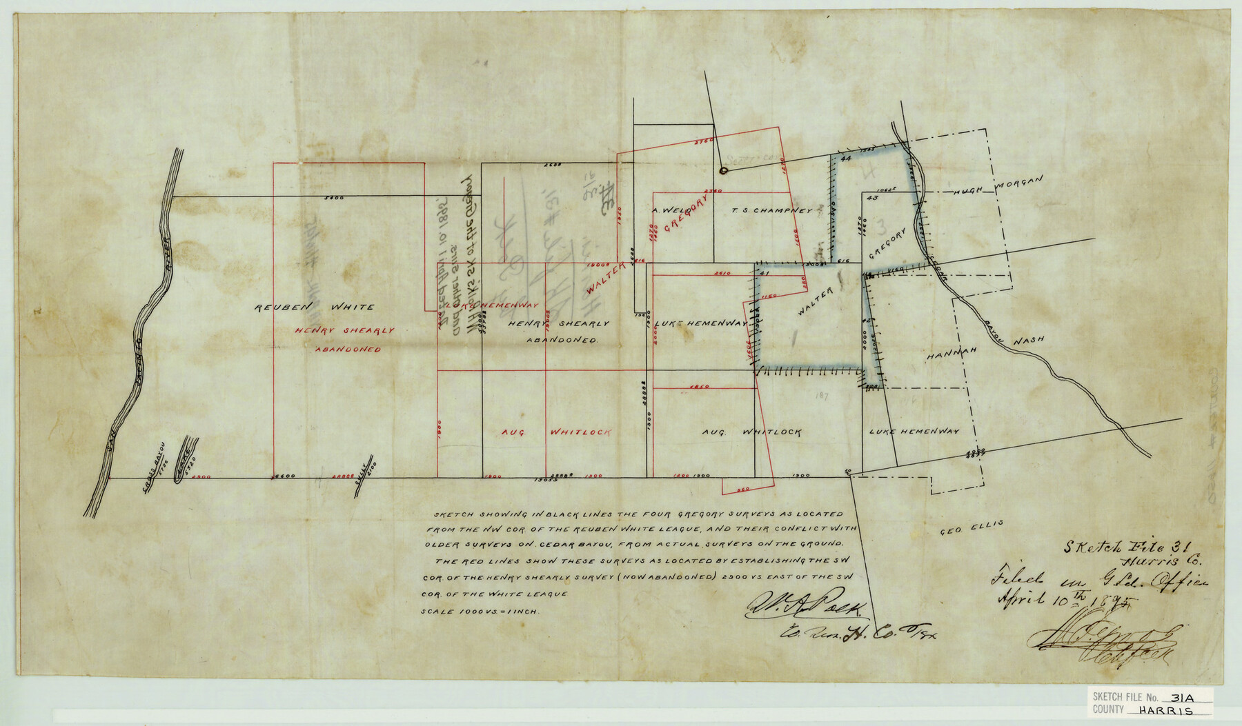
Harris County Sketch File 31a
W. A. Polk's sk. of the Gregory and other surs.
-
Map/Doc
11650
-
Collection
General Map Collection
-
Object Dates
1895/4/10 (Creation Date)
1895/4/10 (File Date)
-
People and Organizations
Pendarvis (Surveyor/Engineer)
W.A Polk (Surveyor/Engineer)
-
Counties
Harris Liberty Chambers
-
Subjects
Surveying Sketch File
-
Height x Width
12.8 x 21.9 inches
32.5 x 55.6 cm
-
Medium
paper, manuscript
-
Scale
1" = 1000 varas
-
Features
San Jacinto River
Cross Bayou
Cedar Bayou
Part of: General Map Collection
Flight Mission No. BRE-1P, Frame 124, Nueces County

Print $20.00
- Digital $50.00
Flight Mission No. BRE-1P, Frame 124, Nueces County
1956
Size 18.6 x 22.7 inches
Map/Doc 86690
Navasota River, Springfield Sheet

Print $20.00
- Digital $50.00
Navasota River, Springfield Sheet
1934
Size 41.5 x 37.8 inches
Map/Doc 65074
Terrell County Rolled Sketch 54

Print $20.00
- Digital $50.00
Terrell County Rolled Sketch 54
Size 18.8 x 22.6 inches
Map/Doc 7973
Ward County Rolled Sketch 24F

Print $40.00
- Digital $50.00
Ward County Rolled Sketch 24F
Size 30.5 x 65.2 inches
Map/Doc 78232
Flight Mission No. DQN-2K, Frame 161, Calhoun County

Print $20.00
- Digital $50.00
Flight Mission No. DQN-2K, Frame 161, Calhoun County
1953
Size 18.5 x 22.3 inches
Map/Doc 84323
Lubbock County Working Sketch 3

Print $20.00
- Digital $50.00
Lubbock County Working Sketch 3
1904
Size 13.9 x 20.5 inches
Map/Doc 70663
Glasscock County Sketch File 4

Print $6.00
- Digital $50.00
Glasscock County Sketch File 4
Size 13.3 x 8.8 inches
Map/Doc 24161
Real County Working Sketch 19

Print $3.00
- Digital $50.00
Real County Working Sketch 19
1944
Size 12.0 x 10.4 inches
Map/Doc 71911
Stephens County Boundary File 5

Print $8.00
- Digital $50.00
Stephens County Boundary File 5
Size 7.6 x 6.4 inches
Map/Doc 58897
Hood County Rolled Sketch 8

Print $20.00
- Digital $50.00
Hood County Rolled Sketch 8
2011
Size 19.3 x 24.5 inches
Map/Doc 90084
Schleicher County Rolled Sketch 10

Print $20.00
- Digital $50.00
Schleicher County Rolled Sketch 10
Size 30.1 x 25.8 inches
Map/Doc 7753
Flight Mission No. CRK-3P, Frame 131, Refugio County

Print $20.00
- Digital $50.00
Flight Mission No. CRK-3P, Frame 131, Refugio County
1956
Size 18.5 x 22.4 inches
Map/Doc 86919
You may also like
Andrews County Sketch File 10

Print $40.00
- Digital $50.00
Andrews County Sketch File 10
1950
Size 27.4 x 18.2 inches
Map/Doc 10810
Flight Mission No. CRC-4R, Frame 159, Chambers County

Print $20.00
- Digital $50.00
Flight Mission No. CRC-4R, Frame 159, Chambers County
1956
Size 18.6 x 22.2 inches
Map/Doc 84918
Val Verde County Working Sketch 43

Print $20.00
- Digital $50.00
Val Verde County Working Sketch 43
1945
Size 39.3 x 37.2 inches
Map/Doc 72178
Flight Mission No. CGI-3N, Frame 135, Cameron County

Print $20.00
- Digital $50.00
Flight Mission No. CGI-3N, Frame 135, Cameron County
1954
Size 18.7 x 22.1 inches
Map/Doc 84608
Dimmit County Rolled Sketch CHM

Print $20.00
- Digital $50.00
Dimmit County Rolled Sketch CHM
1935
Size 38.4 x 43.4 inches
Map/Doc 8795
Kimble County Working Sketch 76

Print $20.00
- Digital $50.00
Kimble County Working Sketch 76
1969
Size 27.7 x 41.0 inches
Map/Doc 70144
Hudspeth County Rolled Sketch 66

Print $20.00
- Digital $50.00
Hudspeth County Rolled Sketch 66
1973
Size 12.1 x 19.9 inches
Map/Doc 6260
Ochiltree County Boundary File 10

Print $24.00
- Digital $50.00
Ochiltree County Boundary File 10
Size 11.2 x 8.7 inches
Map/Doc 57728
Map of the Woodbine Artesian Reservoirs of the Black and Grand Prairies of Texas including the eastern and western Cross Timbers

Print $20.00
- Digital $50.00
Map of the Woodbine Artesian Reservoirs of the Black and Grand Prairies of Texas including the eastern and western Cross Timbers
1900
Size 22.8 x 17.8 inches
Map/Doc 75918
Map of Runnels County

Print $20.00
- Digital $50.00
Map of Runnels County
1858
Size 24.7 x 25.6 inches
Map/Doc 4004
Burleson County Working Sketch Graphic Index

Print $20.00
- Digital $50.00
Burleson County Working Sketch Graphic Index
1978
Size 35.0 x 46.1 inches
Map/Doc 76481
Kaufman County Boundary File 4

Print $52.00
- Digital $50.00
Kaufman County Boundary File 4
Size 7.6 x 8.7 inches
Map/Doc 55934