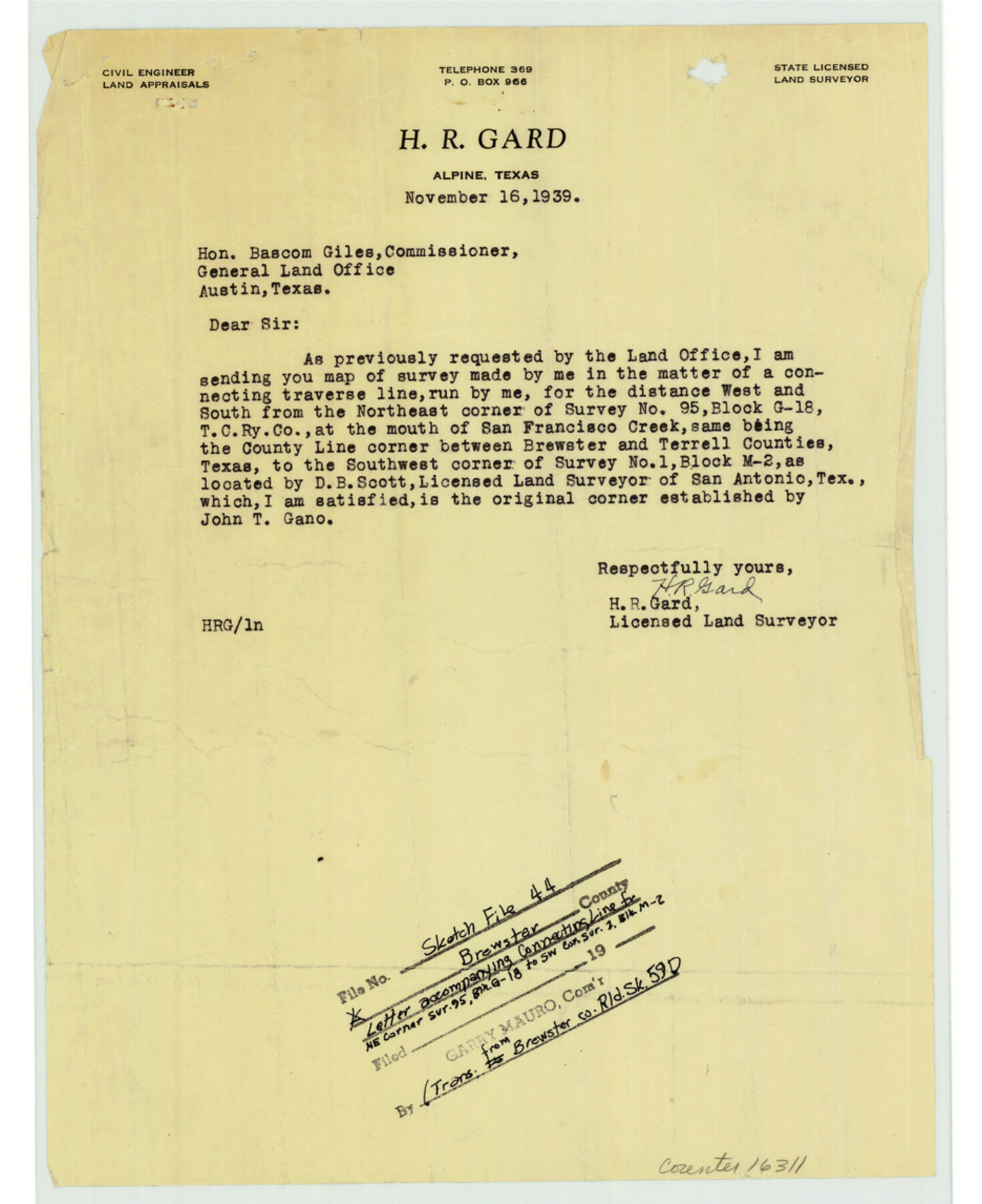
Brewster County Sketch File 44
[Letter accompanying connecting line from northeast corner survey 95, Block G-18 to southwest corner survey 1, Block M-2]
-
Map/Doc
16311
-
Collection
General Map Collection
-
Object Dates
1939/11/16 (Correspondence Date)
-
People and Organizations
H.R. Gard (Surveyor/Engineer)
-
Counties
Brewster Terrell
-
Subjects
Surveying Sketch File
-
Height x Width
11.5 x 9.4 inches
29.2 x 23.9 cm
-
Medium
paper, print
-
Comments
See Brewster County Rolled Sketch 59D (5231) for sketch.
-
Features
San Francisco Creek
Related maps
Brewster County Rolled Sketch 59D

Print $20.00
- Digital $50.00
Brewster County Rolled Sketch 59D
Size 33.3 x 47.3 inches
Map/Doc 5231
Part of: General Map Collection
Yoakum County Working Sketch 1

Print $20.00
- Digital $50.00
Yoakum County Working Sketch 1
1949
Size 18.5 x 19.1 inches
Map/Doc 62023
Travis County Rolled Sketch 38

Print $20.00
- Digital $50.00
Travis County Rolled Sketch 38
Size 31.9 x 30.3 inches
Map/Doc 8038
Dawson County Rolled Sketch 3

Print $20.00
- Digital $50.00
Dawson County Rolled Sketch 3
1903
Size 20.9 x 36.8 inches
Map/Doc 8770
Wharton County Sketch File 10a

Print $20.00
- Digital $50.00
Wharton County Sketch File 10a
Size 11.0 x 19.0 inches
Map/Doc 12660
Lamb County Sketch File 15

Print $6.00
- Digital $50.00
Lamb County Sketch File 15
Size 9.8 x 10.9 inches
Map/Doc 29377
Current Miscellaneous File 84

Print $10.00
- Digital $50.00
Current Miscellaneous File 84
1954
Size 11.2 x 8.8 inches
Map/Doc 74231
Wichita County Sketch File 15

Print $20.00
- Digital $50.00
Wichita County Sketch File 15
1886
Size 18.6 x 12.2 inches
Map/Doc 12679
Schleicher County Rolled Sketch 12

Print $20.00
- Digital $50.00
Schleicher County Rolled Sketch 12
1952
Size 28.8 x 29.0 inches
Map/Doc 7755
Upshur County

Print $20.00
- Digital $50.00
Upshur County
1945
Size 39.8 x 35.8 inches
Map/Doc 73308
Presidio County Rolled Sketch 33

Print $40.00
- Digital $50.00
Presidio County Rolled Sketch 33
Size 57.7 x 42.3 inches
Map/Doc 9772
Atascosa County Sketch File 42

Print $12.00
- Digital $50.00
Atascosa County Sketch File 42
1916
Size 11.2 x 8.8 inches
Map/Doc 13847
Calhoun County Sketch File 11

Print $39.00
- Digital $50.00
Calhoun County Sketch File 11
1957
Size 11.4 x 8.9 inches
Map/Doc 35944
You may also like
Crockett County Working Sketch 22

Print $20.00
- Digital $50.00
Crockett County Working Sketch 22
1920
Size 25.6 x 19.5 inches
Map/Doc 68355
Kimble County Working Sketch 44

Print $20.00
- Digital $50.00
Kimble County Working Sketch 44
1950
Size 29.8 x 36.2 inches
Map/Doc 70112
Flight Mission No. DCL-4C, Frame 120, Kenedy County

Print $20.00
- Digital $50.00
Flight Mission No. DCL-4C, Frame 120, Kenedy County
1943
Size 18.6 x 22.5 inches
Map/Doc 85819
Flight Mission No. BRE-1P, Frame 56, Nueces County

Print $20.00
- Digital $50.00
Flight Mission No. BRE-1P, Frame 56, Nueces County
1956
Size 18.5 x 22.4 inches
Map/Doc 86645
Bowie County Working Sketch 4

Print $20.00
- Digital $50.00
Bowie County Working Sketch 4
1915
Size 19.5 x 14.3 inches
Map/Doc 67408
Map of the United States to accompany Granger's Southern and Western Texas Guide

Print $20.00
Map of the United States to accompany Granger's Southern and Western Texas Guide
1878
Size 26.4 x 20.4 inches
Map/Doc 76236
Coke County Working Sketch 27

Print $20.00
- Digital $50.00
Coke County Working Sketch 27
1962
Size 17.4 x 27.7 inches
Map/Doc 68064
Fort Bend County Working Sketch 4

Print $20.00
- Digital $50.00
Fort Bend County Working Sketch 4
1909
Size 23.5 x 34.8 inches
Map/Doc 69210
Blanco County Rolled Sketch 21

Print $20.00
- Digital $50.00
Blanco County Rolled Sketch 21
2007
Size 18.1 x 13.0 inches
Map/Doc 87925
Map of Nacogdoches County

Print $20.00
- Digital $50.00
Map of Nacogdoches County
1881
Size 24.1 x 21.2 inches
Map/Doc 4603
Hamilton County Working Sketch 33

Print $20.00
- Digital $50.00
Hamilton County Working Sketch 33
Size 32.3 x 33.3 inches
Map/Doc 63371
Brazos River, Brazos River Sheet 5

Print $20.00
- Digital $50.00
Brazos River, Brazos River Sheet 5
1926
Size 27.4 x 21.7 inches
Map/Doc 69669