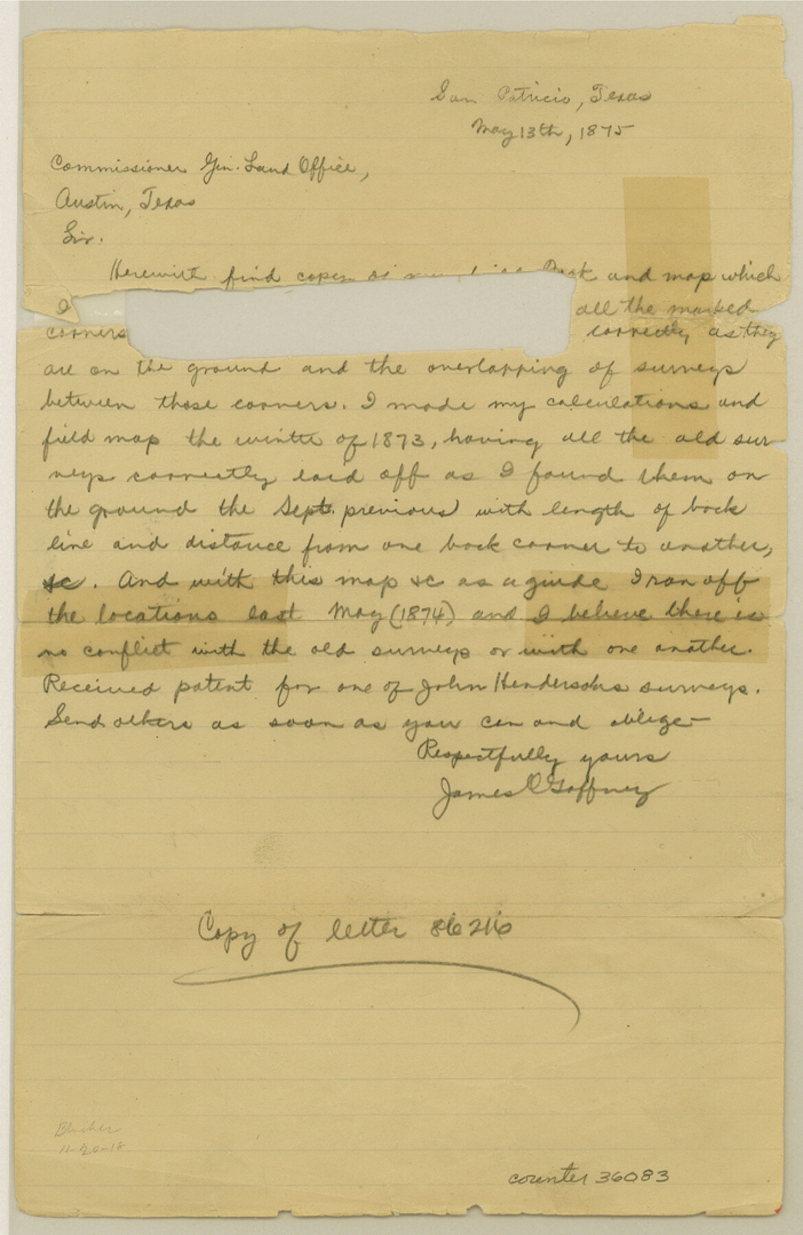
San Patricio County Sketch File 25
[Letter regarding corners of surveys]
-
Map/Doc
36083
-
Collection
General Map Collection
-
Object Dates
5/13/1875 (Creation Date)
-
People and Organizations
James O. Gaffney (Surveyor/Engineer)
-
Counties
San Patricio
-
Subjects
Surveying Sketch File
-
Height x Width
10.8 x 7.0 inches
27.4 x 17.8 cm
-
Medium
paper, manuscript
Part of: General Map Collection
Howard County

Print $20.00
- Digital $50.00
Howard County
1922
Size 42.3 x 36.2 inches
Map/Doc 95535
Goliad County Sketch File 4

Print $6.00
- Digital $50.00
Goliad County Sketch File 4
1857
Size 7.7 x 12.3 inches
Map/Doc 24216
San Saba County Sketch File 2

Print $6.00
- Digital $50.00
San Saba County Sketch File 2
1854
Size 4.8 x 7.4 inches
Map/Doc 36405
Robertson County Sketch File 5 1/2

Print $2.00
- Digital $50.00
Robertson County Sketch File 5 1/2
Size 8.1 x 4.2 inches
Map/Doc 35361
Map of Sabine County

Print $20.00
- Digital $50.00
Map of Sabine County
1896
Size 26.6 x 19.3 inches
Map/Doc 4010
McMullen County Working Sketch 21

Print $40.00
- Digital $50.00
McMullen County Working Sketch 21
1947
Size 38.3 x 53.4 inches
Map/Doc 70722
Duval County Working Sketch 35

Print $20.00
- Digital $50.00
Duval County Working Sketch 35
1956
Size 17.2 x 16.5 inches
Map/Doc 68759
Anderson County Working Sketch 30

Print $20.00
- Digital $50.00
Anderson County Working Sketch 30
1963
Size 29.8 x 41.6 inches
Map/Doc 67030
Irion County Rolled Sketch 10

Print $20.00
- Digital $50.00
Irion County Rolled Sketch 10
1942
Size 29.8 x 29.1 inches
Map/Doc 6322
Houston County Working Sketch 37

Print $20.00
- Digital $50.00
Houston County Working Sketch 37
2006
Size 33.0 x 40.0 inches
Map/Doc 83627
Jefferson County Working Sketch 36

Print $40.00
- Digital $50.00
Jefferson County Working Sketch 36
1982
Size 69.1 x 33.2 inches
Map/Doc 66580
Pecos County Rolled Sketch 168

Print $40.00
- Digital $50.00
Pecos County Rolled Sketch 168
Size 73.5 x 44.7 inches
Map/Doc 9748
You may also like
Parker County Sketch File 19

Print $6.00
- Digital $50.00
Parker County Sketch File 19
1876
Size 11.7 x 10.3 inches
Map/Doc 33556
Comanche County Working Sketch 25

Print $20.00
- Digital $50.00
Comanche County Working Sketch 25
1976
Size 34.8 x 31.9 inches
Map/Doc 68159
Flight Mission No. BQR-3K, Frame 155, Brazoria County

Print $20.00
- Digital $50.00
Flight Mission No. BQR-3K, Frame 155, Brazoria County
1952
Size 18.7 x 22.4 inches
Map/Doc 83982
Anderson County Working Sketch 17

Print $40.00
- Digital $50.00
Anderson County Working Sketch 17
1941
Size 30.3 x 48.8 inches
Map/Doc 67017
Motley County Sketch File 22 (N)

Print $34.00
- Digital $50.00
Motley County Sketch File 22 (N)
1887
Size 8.2 x 8.4 inches
Map/Doc 32069
Flight Mission No. DQN-2K, Frame 145, Calhoun County

Print $20.00
- Digital $50.00
Flight Mission No. DQN-2K, Frame 145, Calhoun County
1953
Size 18.9 x 22.7 inches
Map/Doc 84314
Colorado County Sketch File 21

Print $8.00
- Digital $50.00
Colorado County Sketch File 21
Size 13.1 x 8.8 inches
Map/Doc 18957


Working Sketch in Bastrop County

Print $20.00
- Digital $50.00
Working Sketch in Bastrop County
1923
Size 18.4 x 14.6 inches
Map/Doc 90203
Jim Hogg County

Print $20.00
- Digital $50.00
Jim Hogg County
1962
Size 40.3 x 28.5 inches
Map/Doc 77330
Tom Green County Rolled Sketch 19

Print $20.00
- Digital $50.00
Tom Green County Rolled Sketch 19
1959
Size 35.0 x 32.1 inches
Map/Doc 8002