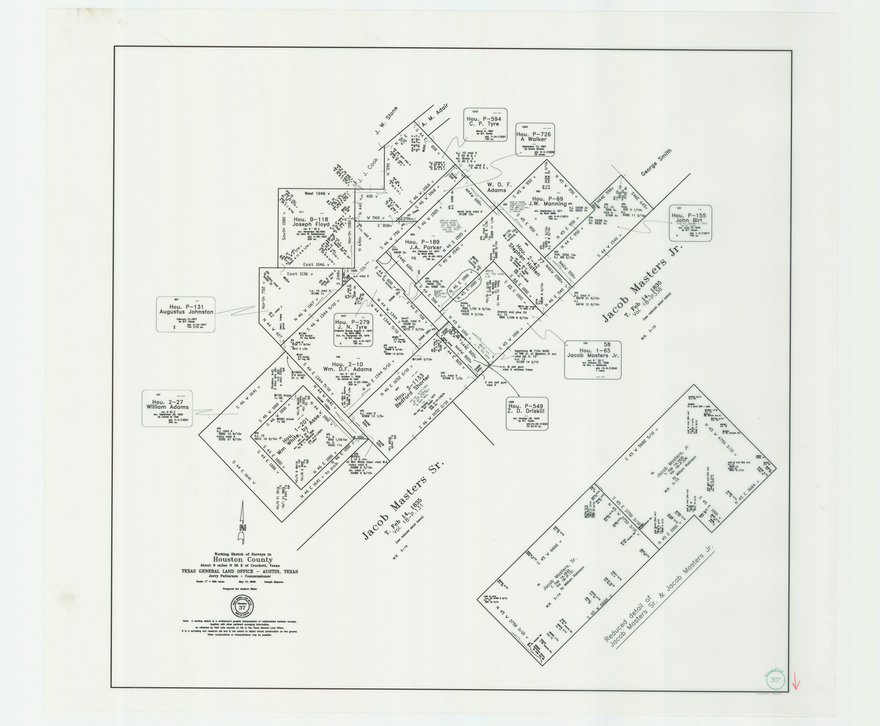
Houston County Working Sketch 37
-
Map/Doc
83627
-
Collection
General Map Collection
-
Object Dates
5/17/2006 (Creation Date)
-
People and Organizations
Jerry E. Patterson (GLO Commissioner)
Joseph Esparza (Draftsman)
-
Counties
Houston
-
Subjects
Surveying Working Sketch
-
Height x Width
33.0 x 40.0 inches
83.8 x 101.6 cm
-
Scale
1" = 300 varas
-
Comments
Located about 9 miles North 35 degrees East of Crockett, Texas.
Part of: General Map Collection
[Sketch for Mineral Application 36486 and 38244 - Liberty County]
![65622, [Sketch for Mineral Application 36486 and 38244 - Liberty County], General Map Collection](https://historictexasmaps.com/wmedia_w700/maps/65622.tif.jpg)
Print $20.00
- Digital $50.00
[Sketch for Mineral Application 36486 and 38244 - Liberty County]
1976
Size 24.0 x 43.9 inches
Map/Doc 65622
Flight Mission No. DQN-1K, Frame 152, Calhoun County

Print $20.00
- Digital $50.00
Flight Mission No. DQN-1K, Frame 152, Calhoun County
1953
Size 18.6 x 22.3 inches
Map/Doc 84211
Garza County Sketch File 4a

Print $4.00
- Digital $50.00
Garza County Sketch File 4a
1883
Size 14.2 x 8.8 inches
Map/Doc 24048
Flight Mission No. DIX-10P, Frame 76, Aransas County

Print $20.00
- Digital $50.00
Flight Mission No. DIX-10P, Frame 76, Aransas County
1956
Size 18.8 x 22.4 inches
Map/Doc 83937
Hemphill County Working Sketch Graphic Index - sheet 2

Print $20.00
- Digital $50.00
Hemphill County Working Sketch Graphic Index - sheet 2
1899
Size 40.2 x 38.2 inches
Map/Doc 76575
Flight Mission No. DAG-23K, Frame 146, Matagorda County

Print $20.00
- Digital $50.00
Flight Mission No. DAG-23K, Frame 146, Matagorda County
1953
Size 17.0 x 22.4 inches
Map/Doc 86494
Amistad International Reservoir on Rio Grande 89a

Print $20.00
- Digital $50.00
Amistad International Reservoir on Rio Grande 89a
1949
Size 28.6 x 40.1 inches
Map/Doc 75518
North Part of Brewster Co.

Print $20.00
- Digital $50.00
North Part of Brewster Co.
1956
Size 40.0 x 37.9 inches
Map/Doc 77220
A Comprehensive Atlas Geographical, Historical & Commercial

A Comprehensive Atlas Geographical, Historical & Commercial
Size 13.0 x 10.7 inches
Map/Doc 95959
Gregg County Sketch File 12

Print $20.00
- Digital $50.00
Gregg County Sketch File 12
Size 17.3 x 24.1 inches
Map/Doc 11589
Bell County Sketch File 17

Print $4.00
- Digital $50.00
Bell County Sketch File 17
Size 8.1 x 9.1 inches
Map/Doc 14398
Val Verde County Working Sketch 40

Print $20.00
- Digital $50.00
Val Verde County Working Sketch 40
1943
Size 31.5 x 29.8 inches
Map/Doc 72175
You may also like
United States - Gulf Coast - Padre I. and Laguna Madre Lat. 27° 12' to Lat. 26° 33' Texas

Print $20.00
- Digital $50.00
United States - Gulf Coast - Padre I. and Laguna Madre Lat. 27° 12' to Lat. 26° 33' Texas
1913
Size 26.9 x 18.2 inches
Map/Doc 72820
Washington County
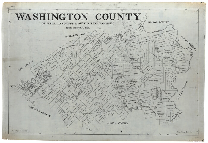
Print $40.00
- Digital $50.00
Washington County
1920
Size 33.5 x 48.8 inches
Map/Doc 1900
Flight Mission No. BRA-6M, Frame 144, Jefferson County

Print $20.00
- Digital $50.00
Flight Mission No. BRA-6M, Frame 144, Jefferson County
1953
Size 18.5 x 22.3 inches
Map/Doc 85445
Lamb County Sketch File 14

Print $6.00
- Digital $50.00
Lamb County Sketch File 14
1914
Size 7.3 x 8.7 inches
Map/Doc 29374
Calhoun County Rolled Sketch 30

Print $20.00
- Digital $50.00
Calhoun County Rolled Sketch 30
1974
Size 18.5 x 27.5 inches
Map/Doc 5496
Refugio County Boundary File 5

Print $4.00
- Digital $50.00
Refugio County Boundary File 5
Size 11.2 x 8.6 inches
Map/Doc 58256
Block 39 of the Brown Subdivision being a part of the Northeast Quarter Section 4, Block O

Print $20.00
- Digital $50.00
Block 39 of the Brown Subdivision being a part of the Northeast Quarter Section 4, Block O
1954
Size 14.8 x 14.2 inches
Map/Doc 92822
Culberson County Rolled Sketch 63

Print $20.00
- Digital $50.00
Culberson County Rolled Sketch 63
1986
Size 19.4 x 24.3 inches
Map/Doc 5679
Upshur County Working Sketch 10

Print $20.00
- Digital $50.00
Upshur County Working Sketch 10
1969
Size 42.1 x 37.0 inches
Map/Doc 69566
From Citizens of Nacogdoches County for the Creation of a New County (Unnamed), October 1839

Print $20.00
From Citizens of Nacogdoches County for the Creation of a New County (Unnamed), October 1839
2020
Size 18.2 x 21.7 inches
Map/Doc 96386
[Atchison, Topeka & Santa Fe from Paisano to south of Plata]
![64713, [Atchison, Topeka & Santa Fe from Paisano to south of Plata], General Map Collection](https://historictexasmaps.com/wmedia_w700/maps/64713-1.tif.jpg)
Print $40.00
- Digital $50.00
[Atchison, Topeka & Santa Fe from Paisano to south of Plata]
Size 32.2 x 116.3 inches
Map/Doc 64713
Trinity County Rolled Sketch 3

Print $40.00
- Digital $50.00
Trinity County Rolled Sketch 3
1948
Size 33.8 x 50.3 inches
Map/Doc 10025