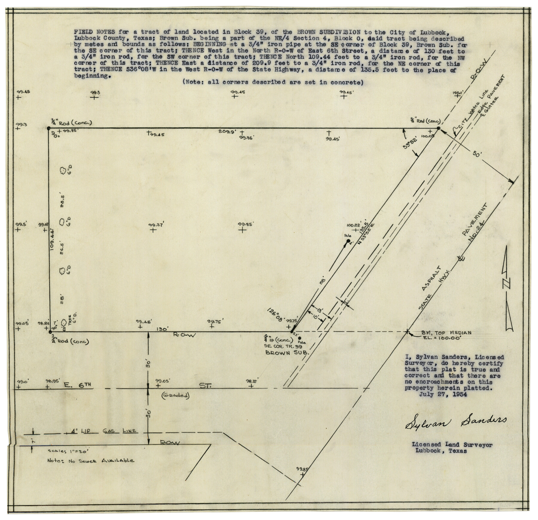
Block 39 of the Brown Subdivision being a part of the Northeast Quarter Section 4, Block O
-
Map/Doc
92822
-
Collection
Twichell Survey Records
-
Object Dates
7/27/1954 (Creation Date)
-
People and Organizations
Sylvan Sanders (Surveyor/Engineer)
-
Counties
Lubbock
-
Height x Width
14.8 x 14.2 inches
37.6 x 36.1 cm
Part of: Twichell Survey Records
[Southwest corner of county covering Blks. 24 and B9]
![90489, [Southwest corner of county covering Blks. 24 and B9], Twichell Survey Records](https://historictexasmaps.com/wmedia_w700/maps/90489-1.tif.jpg)
Print $20.00
- Digital $50.00
[Southwest corner of county covering Blks. 24 and B9]
1905
Size 16.7 x 13.9 inches
Map/Doc 90489
[Sketch of area around C. & M. RR. Co. survey 171]
![90214, [Sketch of area around C. & M. RR. Co. survey 171], Twichell Survey Records](https://historictexasmaps.com/wmedia_w700/maps/90214-1.tif.jpg)
Print $20.00
- Digital $50.00
[Sketch of area around C. & M. RR. Co. survey 171]
1924
Size 21.8 x 26.9 inches
Map/Doc 90214
[Southwest Portion of Glasscock County]
![90765, [Southwest Portion of Glasscock County], Twichell Survey Records](https://historictexasmaps.com/wmedia_w700/maps/90765-1.tif.jpg)
Print $20.00
- Digital $50.00
[Southwest Portion of Glasscock County]
Size 18.7 x 20.9 inches
Map/Doc 90765
[Sketch showing I. & G. N. Block 1 along river, Runnels County School Land and Ira G. Yates]
![91595, [Sketch showing I. & G. N. Block 1 along river, Runnels County School Land and Ira G. Yates], Twichell Survey Records](https://historictexasmaps.com/wmedia_w700/maps/91595-1.tif.jpg)
Print $20.00
- Digital $50.00
[Sketch showing I. & G. N. Block 1 along river, Runnels County School Land and Ira G. Yates]
Size 17.2 x 23.3 inches
Map/Doc 91595
[H.& G.N. Block B3 in NE corner of County]
![90272, [H.& G.N. Block B3 in NE corner of County], Twichell Survey Records](https://historictexasmaps.com/wmedia_w700/maps/90272-1.tif.jpg)
Print $3.00
- Digital $50.00
[H.& G.N. Block B3 in NE corner of County]
Size 13.8 x 9.7 inches
Map/Doc 90272
[Double Lakes Area Northwest of Tohoka, Block 3, Surveys 319, 321, and 322]
![91298, [Double Lakes Area Northwest of Tohoka, Block 3, Surveys 319, 321, and 322], Twichell Survey Records](https://historictexasmaps.com/wmedia_w700/maps/91298-1.tif.jpg)
Print $20.00
- Digital $50.00
[Double Lakes Area Northwest of Tohoka, Block 3, Surveys 319, 321, and 322]
Size 21.1 x 20.1 inches
Map/Doc 91298
[Blocks K11, K6, K5, M19, H1, and Leagues North of Block S]
![91409, [Blocks K11, K6, K5, M19, H1, and Leagues North of Block S], Twichell Survey Records](https://historictexasmaps.com/wmedia_w700/maps/91409-1.tif.jpg)
Print $20.00
- Digital $50.00
[Blocks K11, K6, K5, M19, H1, and Leagues North of Block S]
1902
Size 33.3 x 25.3 inches
Map/Doc 91409
Map Showing Lands Surveyed by Sylvan Sanders, Block D

Print $20.00
- Digital $50.00
Map Showing Lands Surveyed by Sylvan Sanders, Block D
Size 28.9 x 24.2 inches
Map/Doc 92441
Map B [showing surveys along river and in vicinity of Archer County School Land League 3]
![89752, Map B [showing surveys along river and in vicinity of Archer County School Land League 3], Twichell Survey Records](https://historictexasmaps.com/wmedia_w700/maps/89752-1.tif.jpg)
Print $20.00
- Digital $50.00
Map B [showing surveys along river and in vicinity of Archer County School Land League 3]
Size 42.7 x 38.0 inches
Map/Doc 89752

[Sections 2-5, H. & G. N. Block 12]
![91583, [Sections 2-5, H. & G. N. Block 12], Twichell Survey Records](https://historictexasmaps.com/wmedia_w700/maps/91583-1.tif.jpg)
Print $2.00
- Digital $50.00
[Sections 2-5, H. & G. N. Block 12]
Size 12.3 x 9.2 inches
Map/Doc 91583
[East Half of Hockley County]
![91194, [East Half of Hockley County], Twichell Survey Records](https://historictexasmaps.com/wmedia_w700/maps/91194-1.tif.jpg)
Print $20.00
- Digital $50.00
[East Half of Hockley County]
Size 26.0 x 35.5 inches
Map/Doc 91194
You may also like
Hartley County Sketch File 5

Print $8.00
- Digital $50.00
Hartley County Sketch File 5
1883
Size 12.7 x 8.1 inches
Map/Doc 26090
Map Showing Eastern Portion of Pecos County, Texas

Print $40.00
- Digital $50.00
Map Showing Eastern Portion of Pecos County, Texas
Size 62.2 x 43.5 inches
Map/Doc 89835
Young County Working Sketch 13

Print $20.00
- Digital $50.00
Young County Working Sketch 13
1938
Size 46.0 x 40.4 inches
Map/Doc 62036
Pecos County Rolled Sketch 83

Print $20.00
- Digital $50.00
Pecos County Rolled Sketch 83
1931
Size 17.6 x 26.2 inches
Map/Doc 7242
[County map showing Texas State Capitol Land and surrounding areas]
![93141, [County map showing Texas State Capitol Land and surrounding areas], Twichell Survey Records](https://historictexasmaps.com/wmedia_w700/maps/93141-1.tif.jpg)
Print $40.00
- Digital $50.00
[County map showing Texas State Capitol Land and surrounding areas]
Size 51.5 x 66.7 inches
Map/Doc 93141
Pecos County Working Sketch 136

Print $20.00
- Digital $50.00
Pecos County Working Sketch 136
1981
Size 31.8 x 28.4 inches
Map/Doc 71610
Chambers County Sketch File 52

Print $8.00
- Digital $50.00
Chambers County Sketch File 52
1839
Size 13.0 x 8.3 inches
Map/Doc 18083
Presidio County Working Sketch 112

Print $20.00
- Digital $50.00
Presidio County Working Sketch 112
1979
Size 41.7 x 35.6 inches
Map/Doc 71789
Wharton County Working Sketch 19

Print $20.00
- Digital $50.00
Wharton County Working Sketch 19
1940
Size 21.4 x 23.0 inches
Map/Doc 72483
Hays County Sketch File 28

Print $20.00
- Digital $50.00
Hays County Sketch File 28
1912
Size 26.0 x 20.0 inches
Map/Doc 11750
Freestone County Working Sketch Graphic Index

Print $20.00
- Digital $50.00
Freestone County Working Sketch Graphic Index
1988
Size 43.0 x 42.1 inches
Map/Doc 76547
Hardin County Sketch File 51

Print $9.00
- Digital $50.00
Hardin County Sketch File 51
Size 9.9 x 8.1 inches
Map/Doc 25206