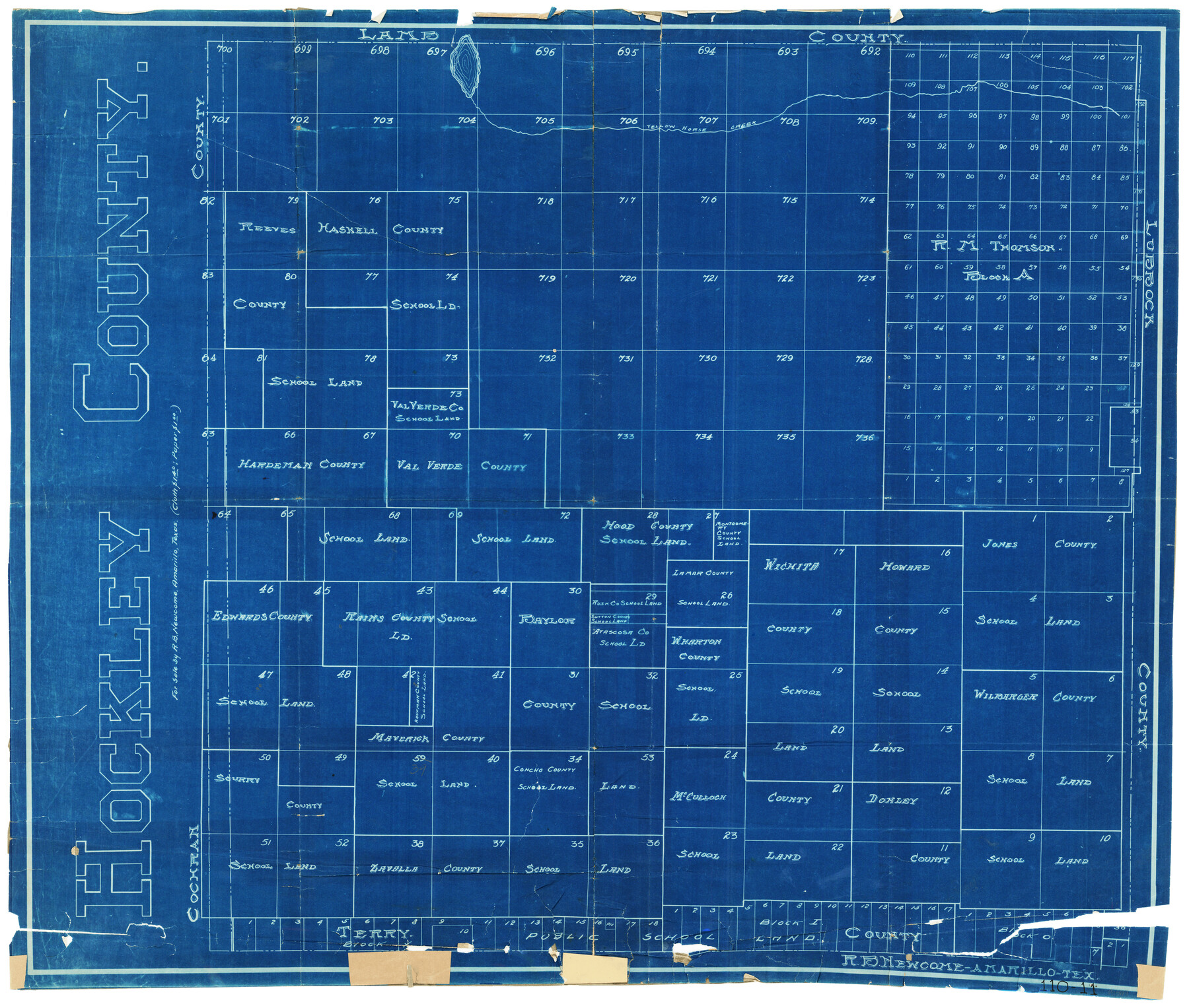
Hockley County
110-11
- 
                          Map/Doc92981
- 
                            CollectionTwichell Survey Records
- 
                            CountiesHockley
- 
                            SubjectsCounty
- 
                            Height x Width24.3 x 20.8 inches61.7 x 52.8 cm
Part of: Twichell Survey Records
            Working Sketch Hale County


                                            Print $20.00                    
                                             -                         Digital $50.00                                    
                Working Sketch Hale County
1909
Size 17.9 x 20.9 inches
                                Map/Doc 90745
            
            Map Showing a Resurvey of Part of Blk. I, H. &. G. N. Ry. Co. Pecos County, Texas, following field notes copied from Jacob Kuechler's field book of his original survey made in October and November 1876


                                            Print $20.00                    
                                             -                         Digital $50.00                                    
                Map Showing a Resurvey of Part of Blk. I, H. &. G. N. Ry. Co. Pecos County, Texas, following field notes copied from Jacob Kuechler's field book of his original survey made in October and November 1876
1930
Size 19.2 x 14.4 inches
                                Map/Doc 91549
            
            Alexander's Subdivision Tract 2, League 64 Midland County School Land, Cochran County, Texas


                                            Print $20.00                    
                                             -                         Digital $50.00                                    
                Alexander's Subdivision Tract 2, League 64 Midland County School Land, Cochran County, Texas
1937
Size 19.1 x 22.7 inches
                                Map/Doc 92518
            
            [Sketch showing Blocks 5, M-20, 22 and strip of Block BB]
            
                                    ![91723, [Sketch showing Blocks 5, M-20, 22 and strip of Block BB], Twichell Survey Records](https://historictexasmaps.com/wmedia_w700/maps/91723-1.tif.jpg) 


    ![91723, [Sketch showing Blocks 5, M-20, 22 and strip of Block BB], Twichell Survey Records](https://historictexasmaps.com/wmedia_w700/maps/91723-1.tif.jpg) 
                                
            
                                            Print $2.00                    
                                             -                         Digital $50.00                                    
                [Sketch showing Blocks 5, M-20, 22 and strip of Block BB]
Size 7.1 x 10.4 inches
                                Map/Doc 91723
            
            G&H Blocks Gaines Co. Resurvey 1915


                                            Print $40.00                    
                                             -                         Digital $50.00                                    
                G&H Blocks Gaines Co. Resurvey 1915
1915
Size 56.8 x 31.3 inches
                                Map/Doc 89632
            
            Subdivisions of Capitol Leagues 93, 94, 95, 96, 104, 105, 106, 107, 116, 117, 118, 127, 128, 129, 130, 131, 132, 140, 141, 142 and parts of 75, 83, 84, 85, 86, 108, 143, 144, 145


                                            Print $20.00                    
                                             -                         Digital $50.00                                    
                Subdivisions of Capitol Leagues 93, 94, 95, 96, 104, 105, 106, 107, 116, 117, 118, 127, 128, 129, 130, 131, 132, 140, 141, 142 and parts of 75, 83, 84, 85, 86, 108, 143, 144, 145
1906
Size 16.7 x 26.7 inches
                                Map/Doc 90650
            
            [League 27, Montgomery County School Land, William Tubbs Survey]
            
                                    ![91127, [League 27, Montgomery County School Land, William Tubbs Survey], Twichell Survey Records](https://historictexasmaps.com/wmedia_w700/maps/91127-1.tif.jpg) 


    ![91127, [League 27, Montgomery County School Land, William Tubbs Survey], Twichell Survey Records](https://historictexasmaps.com/wmedia_w700/maps/91127-1.tif.jpg) 
                                
            
                                            Print $2.00                    
                                             -                         Digital $50.00                                    
                [League 27, Montgomery County School Land, William Tubbs Survey]
Size 11.7 x 8.9 inches
                                Map/Doc 91127
            
            Sketch Showing Division Fence Shelton-Matador


                                            Print $20.00                    
                                             -                         Digital $50.00                                    
                Sketch Showing Division Fence Shelton-Matador
Size 21.3 x 24.1 inches
                                Map/Doc 91446
            
            Lamb County, Texas Compiled by Sylvan Sanders Lubbock, Texas


                                            Print $20.00                    
                                             -                         Digital $50.00                                    
                Lamb County, Texas Compiled by Sylvan Sanders Lubbock, Texas
Size 24.0 x 27.2 inches
                                Map/Doc 92200
            
            Plat Showing Block Z, W. D. and F. W. Johnson Subdivision, Bailey County, Texas


                                            Print $20.00                    
                                             -                         Digital $50.00                                    
                Plat Showing Block Z, W. D. and F. W. Johnson Subdivision, Bailey County, Texas
1955
Size 24.3 x 15.7 inches
                                Map/Doc 92538
            
            [Leagues 7, 8, 9, and 10]
            
                                    ![92216, [Leagues 7, 8, 9, and 10], Twichell Survey Records](https://historictexasmaps.com/wmedia_w700/maps/92216-1.tif.jpg) 


    ![92216, [Leagues 7, 8, 9, and 10], Twichell Survey Records](https://historictexasmaps.com/wmedia_w700/maps/92216-1.tif.jpg) 
                                
            
                                            Print $20.00                    
                                             -                         Digital $50.00                                    
                [Leagues 7, 8, 9, and 10]
Size 38.3 x 26.2 inches
                                Map/Doc 92216
            
            [Sketch showing C. W. Dakan, Wm. H. Walker and surrounding surveys]
            
                                    ![90880, [Sketch showing C. W. Dakan, Wm. H. Walker and surrounding surveys], Twichell Survey Records](https://historictexasmaps.com/wmedia_w700/maps/90880-1.tif.jpg) 


    ![90880, [Sketch showing C. W. Dakan, Wm. H. Walker and surrounding surveys], Twichell Survey Records](https://historictexasmaps.com/wmedia_w700/maps/90880-1.tif.jpg) 
                                
            
                                            Print $2.00                    
                                             -                         Digital $50.00                                    
                [Sketch showing C. W. Dakan, Wm. H. Walker and surrounding surveys]
1919
Size 8.9 x 12.3 inches
                                Map/Doc 90880
            You may also like
            [J. Poitevent Blocks 1 and 2, T. & P. Blocks 31-36, Townships 3N-5N and other Blocks in vicinity]
            
                                    ![93195, [J. Poitevent Blocks 1 and 2, T. & P. Blocks 31-36, Townships 3N-5N and other Blocks in vicinity], Twichell Survey Records](https://historictexasmaps.com/wmedia_w700/maps/93195-1.tif.jpg) 


    ![93195, [J. Poitevent Blocks 1 and 2, T. & P. Blocks 31-36, Townships 3N-5N and other Blocks in vicinity], Twichell Survey Records](https://historictexasmaps.com/wmedia_w700/maps/93195-1.tif.jpg) 
                                
            
                                            Print $40.00                    
                                             -                         Digital $50.00                                    
                [J. Poitevent Blocks 1 and 2, T. & P. Blocks 31-36, Townships 3N-5N and other Blocks in vicinity]
Size 50.0 x 50.1 inches
                                Map/Doc 93195
            
            Map of Northern Boundary Line of Texas and Pacific 80 Mile Reservation


                                            Print $20.00                    
                                             -                         Digital $50.00                                    
                Map of Northern Boundary Line of Texas and Pacific 80 Mile Reservation
1902
Size 16.8 x 16.7 inches
                                Map/Doc 65694
            
            Reeves County Working Sketch 52


                                            Print $40.00                    
                                             -                         Digital $50.00                                    
                Reeves County Working Sketch 52
1977
Size 60.3 x 41.9 inches
                                Map/Doc 63495
            
            [Surveys in the Bexar District along the Leona River]
            
                                    ![135, [Surveys in the Bexar District along the Leona River], General Map Collection](https://historictexasmaps.com/wmedia_w700/maps/135.tif.jpg) 


    ![135, [Surveys in the Bexar District along the Leona River], General Map Collection](https://historictexasmaps.com/wmedia_w700/maps/135.tif.jpg) 
                                
            
                                            Print $20.00                    
                                             -                         Digital $50.00                                    
                [Surveys in the Bexar District along the Leona River]
1841
Size 19.9 x 10.9 inches
                                Map/Doc 135
            
            Connected Map of Austin's Colony


                                            Print $40.00                    
                                             -                         Digital $50.00                                    
                Connected Map of Austin's Colony
1837
Size 93.2 x 43.1 inches
                                Map/Doc 93376
            
            Goliad County Sketch File 29


                                            Print $2.00                    
                                             -                         Digital $50.00                                    
                Goliad County Sketch File 29
Size 12.6 x 8.0 inches
                                Map/Doc 24326
            
            Val Verde County Working Sketch 26


                                            Print $20.00                    
                                             -                         Digital $50.00                                    
                Val Verde County Working Sketch 26
1936
Size 22.9 x 31.5 inches
                                Map/Doc 72161
            
            Map of Henderson County


                                            Print $20.00                    
                                             -                         Digital $50.00                                    
                Map of Henderson County
1871
Size 16.3 x 30.3 inches
                                Map/Doc 4563
            
            [Sketch of surveys between Miguel Perez and Francisco Antonio Villareal grants, Starr County]
            
                                    ![5074, [Sketch of surveys between Miguel Perez and Francisco Antonio Villareal grants, Starr County], Maddox Collection](https://historictexasmaps.com/wmedia_w700/maps/5074.tif.jpg) 


    ![5074, [Sketch of surveys between Miguel Perez and Francisco Antonio Villareal grants, Starr County], Maddox Collection](https://historictexasmaps.com/wmedia_w700/maps/5074.tif.jpg) 
                                
            
                                            Print $3.00                    
                                             -                         Digital $50.00                                    
                [Sketch of surveys between Miguel Perez and Francisco Antonio Villareal grants, Starr County]
1914
Size 16.7 x 10.6 inches
                                Map/Doc 5074
            
            Presidio County Rolled Sketch 4


                                            Print $2.00                    
                                             -                         Digital $50.00                                    
                Presidio County Rolled Sketch 4
Size 10.1 x 6.3 inches
                                Map/Doc 75984
            
            Uvalde County Rolled Sketch 9


                                            Print $20.00                    
                                             -                         Digital $50.00                                    
                Uvalde County Rolled Sketch 9
1924
Size 16.6 x 24.6 inches
                                Map/Doc 8094
             
                        