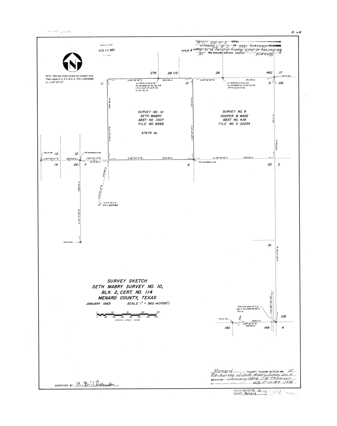
Menard County Rolled Sketch 15
Survey sketch Seth Mabry survey no. 10, Blk. 2, cert. no. 114, Menard County, Texas
-
Map/Doc
6761
-
Collection
General Map Collection
-
Object Dates
1983 (Creation Date)
1983/2/10 (File Date)
-
People and Organizations
C.B. Thomson (Surveyor/Engineer)
-
Counties
Menard
-
Subjects
Surveying Rolled Sketch
-
Height x Width
27.9 x 22.0 inches
70.9 x 55.9 cm
-
Medium
mylar, print
-
Scale
1" = 360 varas
Part of: General Map Collection
Outer Continental Shelf Leasing Maps (Louisiana Offshore Operations)

Print $20.00
- Digital $50.00
Outer Continental Shelf Leasing Maps (Louisiana Offshore Operations)
1959
Size 17.8 x 14.1 inches
Map/Doc 76095
Map of the country in the vicinity of San Antonio de Bexar reduced in part from the county map of Bexar with additions by J. Edmd. Blake, 1st Lieut Topl. Engs.

Print $20.00
- Digital $50.00
Map of the country in the vicinity of San Antonio de Bexar reduced in part from the county map of Bexar with additions by J. Edmd. Blake, 1st Lieut Topl. Engs.
1845
Size 18.1 x 25.9 inches
Map/Doc 72723
Jackson County Sketch File 30

Print $52.00
- Digital $50.00
Jackson County Sketch File 30
1944
Size 14.2 x 8.5 inches
Map/Doc 27730
Crockett County Working Sketch 71

Print $20.00
- Digital $50.00
Crockett County Working Sketch 71
1963
Size 38.7 x 32.7 inches
Map/Doc 68404
Brazoria County Sketch File 52

Print $6.00
- Digital $50.00
Brazoria County Sketch File 52
Size 14.5 x 8.0 inches
Map/Doc 15313
Drainage Basins of Texas Streams

Print $20.00
- Digital $50.00
Drainage Basins of Texas Streams
Size 35.3 x 42.0 inches
Map/Doc 65270
Baylor County Sketch File 11C

Print $20.00
- Digital $50.00
Baylor County Sketch File 11C
1892
Map/Doc 88491
Winkler County Working Sketch 9

Print $40.00
- Digital $50.00
Winkler County Working Sketch 9
1950
Size 42.9 x 50.0 inches
Map/Doc 72603
Sulphur River and Cut Hand Creek, Hardison Lake Sheet

Print $20.00
- Digital $50.00
Sulphur River and Cut Hand Creek, Hardison Lake Sheet
1919
Size 22.5 x 24.2 inches
Map/Doc 65177
Culberson County Sketch File 36

Print $28.00
- Digital $50.00
Culberson County Sketch File 36
1957
Size 11.3 x 8.7 inches
Map/Doc 20302
Flight Mission No. BRA-9M, Frame 72, Jefferson County

Print $20.00
- Digital $50.00
Flight Mission No. BRA-9M, Frame 72, Jefferson County
1953
Size 18.5 x 22.6 inches
Map/Doc 85655
Harbor Pass and Bar at Brazos Santiago, Texas

Print $20.00
- Digital $50.00
Harbor Pass and Bar at Brazos Santiago, Texas
1871
Size 18.4 x 27.4 inches
Map/Doc 73039
You may also like
Hemphill County Rolled Sketch 15

Print $20.00
- Digital $50.00
Hemphill County Rolled Sketch 15
1961
Size 44.7 x 21.5 inches
Map/Doc 6194
[Sketch showing B. S. & F. survey 9, sections 162, 163, 178, 179 in town of Bush]
![91728, [Sketch showing B. S. & F. survey 9, sections 162, 163, 178, 179 in town of Bush], Twichell Survey Records](https://historictexasmaps.com/wmedia_w700/maps/91728-1.tif.jpg)
Print $20.00
- Digital $50.00
[Sketch showing B. S. & F. survey 9, sections 162, 163, 178, 179 in town of Bush]
Size 12.0 x 16.1 inches
Map/Doc 91728
Presidio County Rolled Sketch 147

Print $20.00
- Digital $50.00
Presidio County Rolled Sketch 147
2019
Size 35.2 x 24.1 inches
Map/Doc 95703
Flight Mission No. DAG-21K, Frame 100, Matagorda County

Print $20.00
- Digital $50.00
Flight Mission No. DAG-21K, Frame 100, Matagorda County
1952
Size 18.6 x 22.3 inches
Map/Doc 86429
San Patricio County Rolled Sketch 22

Print $20.00
- Digital $50.00
San Patricio County Rolled Sketch 22
1882
Size 19.3 x 23.9 inches
Map/Doc 7581
Map of Germany, Switzerland and Northern Italy engraved to illustrate Mitchell's school and family geography

Print $20.00
- Digital $50.00
Map of Germany, Switzerland and Northern Italy engraved to illustrate Mitchell's school and family geography
1840
Size 11.8 x 9.5 inches
Map/Doc 93504
Upshur County Sketch File 7

Print $4.00
- Digital $50.00
Upshur County Sketch File 7
1849
Size 8.2 x 10.2 inches
Map/Doc 38744
Harris County Sketch File 74

Print $22.00
- Digital $50.00
Harris County Sketch File 74
1944
Size 17.1 x 12.2 inches
Map/Doc 25543
Atascosa County Rolled Sketch 19

Print $20.00
- Digital $50.00
Atascosa County Rolled Sketch 19
1955
Size 22.1 x 18.3 inches
Map/Doc 5099
Fair View Heights Addition to City of Lubbock Located on Survey 80, Blk. A

Print $20.00
- Digital $50.00
Fair View Heights Addition to City of Lubbock Located on Survey 80, Blk. A
Size 16.8 x 21.1 inches
Map/Doc 92760
Leon County Rolled Sketch 20

Print $20.00
- Digital $50.00
Leon County Rolled Sketch 20
Size 27.0 x 25.8 inches
Map/Doc 6607
Flight Mission No. DCL-7C, Frame 67, Kenedy County

Print $20.00
- Digital $50.00
Flight Mission No. DCL-7C, Frame 67, Kenedy County
1943
Size 15.5 x 15.3 inches
Map/Doc 86053