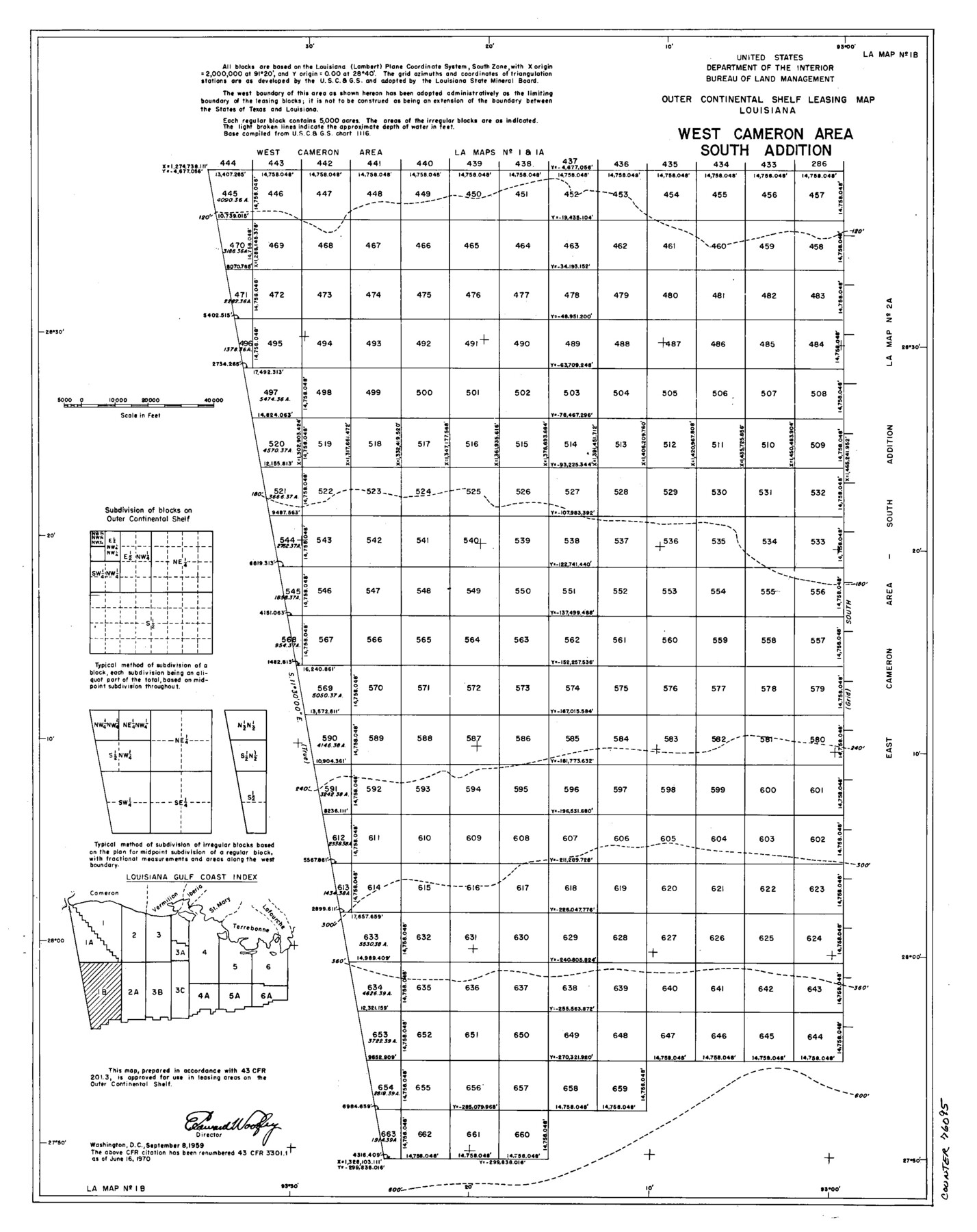
Outer Continental Shelf Leasing Maps (Louisiana Offshore Operations)
D-7-3; D-7-4
-
Map/Doc
76095
-
Collection
General Map Collection
-
Object Dates
1959/9/8 (Creation Date)
-
Subjects
Energy Offshore Submerged Area
-
Height x Width
17.8 x 14.1 inches
45.2 x 35.8 cm
Part of: General Map Collection
San Patricio County NRC Article 33.136 Location Key Sheet

Print $20.00
- Digital $50.00
San Patricio County NRC Article 33.136 Location Key Sheet
1975
Size 27.0 x 23.0 inches
Map/Doc 77037
Flight Mission No. CUG-1P, Frame 48, Kleberg County

Print $20.00
- Digital $50.00
Flight Mission No. CUG-1P, Frame 48, Kleberg County
1956
Size 18.5 x 22.3 inches
Map/Doc 86126
Garza County Rolled Sketch 13

Print $26.00
- Digital $50.00
Garza County Rolled Sketch 13
1935
Size 45.5 x 36.7 inches
Map/Doc 9047
Liberty County Sketch File 5b

Print $6.00
- Digital $50.00
Liberty County Sketch File 5b
1857
Size 8.0 x 3.5 inches
Map/Doc 29890
Polk County Working Sketch 34

Print $20.00
- Digital $50.00
Polk County Working Sketch 34
1961
Size 41.3 x 42.0 inches
Map/Doc 71651
Travis County Sketch File 30

Print $6.00
- Digital $50.00
Travis County Sketch File 30
1884
Size 17.0 x 11.0 inches
Map/Doc 38343
Flight Mission No. CLL-3N, Frame 35, Willacy County

Print $20.00
- Digital $50.00
Flight Mission No. CLL-3N, Frame 35, Willacy County
1954
Size 18.3 x 22.1 inches
Map/Doc 87093
Galveston County Sketch File 9

Print $6.00
- Digital $50.00
Galveston County Sketch File 9
1866
Size 10.1 x 8.1 inches
Map/Doc 23369
Ward County Working Sketch 37

Print $20.00
- Digital $50.00
Ward County Working Sketch 37
1969
Size 31.3 x 46.9 inches
Map/Doc 72343
Sketch showing progress of topographical work Laguna Madre and vicinity from Rainey Is. to Baffins Bay, Coast of Texas Sect. IX [and accompanying letter]
![72960, Sketch showing progress of topographical work Laguna Madre and vicinity from Rainey Is. to Baffins Bay, Coast of Texas Sect. IX [and accompanying letter], General Map Collection](https://historictexasmaps.com/wmedia_w700/maps/72960.tif.jpg)
Print $2.00
- Digital $50.00
Sketch showing progress of topographical work Laguna Madre and vicinity from Rainey Is. to Baffins Bay, Coast of Texas Sect. IX [and accompanying letter]
1881
Size 11.1 x 8.8 inches
Map/Doc 72960
Gillespie County Rolled Sketch 1

Print $20.00
- Digital $50.00
Gillespie County Rolled Sketch 1
1956
Size 19.7 x 36.1 inches
Map/Doc 6008
Upshur County Sketch File 4

Print $4.00
- Digital $50.00
Upshur County Sketch File 4
1851
Size 4.7 x 6.5 inches
Map/Doc 38738
You may also like
Flight Mission No. DAG-16K, Frame 73, Matagorda County

Print $20.00
- Digital $50.00
Flight Mission No. DAG-16K, Frame 73, Matagorda County
1952
Size 16.5 x 16.3 inches
Map/Doc 86319
Flight Mission No. BRA-7M, Frame 27, Jefferson County

Print $20.00
- Digital $50.00
Flight Mission No. BRA-7M, Frame 27, Jefferson County
1953
Size 18.5 x 22.3 inches
Map/Doc 85478
Three-Way Consolidated County Line Independent School District, Bailey and Cochran Counties, Texas

Print $20.00
- Digital $50.00
Three-Way Consolidated County Line Independent School District, Bailey and Cochran Counties, Texas
Size 34.2 x 26.8 inches
Map/Doc 92527
Lamb County Working Sketch Graphic Index

Print $20.00
- Digital $50.00
Lamb County Working Sketch Graphic Index
1961
Size 43.8 x 34.1 inches
Map/Doc 76613
Zapata County Sketch File 5

Print $20.00
- Digital $50.00
Zapata County Sketch File 5
1886
Size 15.4 x 16.9 inches
Map/Doc 12719
Robertson County Working Sketch 7

Print $20.00
- Digital $50.00
Robertson County Working Sketch 7
1983
Size 36.4 x 38.5 inches
Map/Doc 63580
Map of the Central and Montgomery Railroad

Print $20.00
- Digital $50.00
Map of the Central and Montgomery Railroad
1881
Size 12.6 x 36.8 inches
Map/Doc 64141
Copy of Surveyor's Field Book, Morris Browning - In Blocks 7, 5 & 4, I&GNRRCo., Hutchinson and Carson Counties, Texas

Print $3.00
- Digital $50.00
Copy of Surveyor's Field Book, Morris Browning - In Blocks 7, 5 & 4, I&GNRRCo., Hutchinson and Carson Counties, Texas
1888
Size 12.7 x 9.7 inches
Map/Doc 62258
Hidalgo County Rolled Sketch 7

Print $20.00
- Digital $50.00
Hidalgo County Rolled Sketch 7
1905
Size 20.4 x 26.1 inches
Map/Doc 6208
Hardeman County Working Sketch Graphic Index

Print $20.00
- Digital $50.00
Hardeman County Working Sketch Graphic Index
1935
Size 42.9 x 40.5 inches
Map/Doc 76566
Duval County Rolled Sketch 50

Print $20.00
- Digital $50.00
Duval County Rolled Sketch 50
1876
Size 14.2 x 11.8 inches
Map/Doc 5764
Denton County Sketch File 6

Print $4.00
- Digital $50.00
Denton County Sketch File 6
1855
Size 12.3 x 8.3 inches
Map/Doc 20696