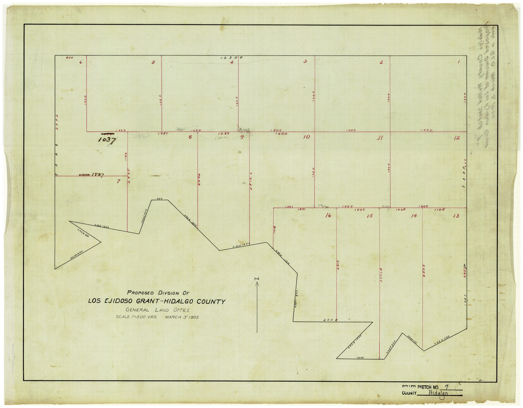
Hidalgo County Rolled Sketch 7
Proposed division of Los Ejidoso grant in Hidalgo County
-
Map/Doc
6208
-
Collection
General Map Collection
-
Object Dates
3/3/1905 (Creation Date)
-
Counties
Hidalgo
-
Subjects
Surveying Rolled Sketch
-
Height x Width
20.4 x 26.1 inches
51.8 x 66.3 cm
-
Medium
linen, manuscript
-
Scale
1" = 500 varas
Part of: General Map Collection
Reagan County Sketch File 31

Print $20.00
- Digital $50.00
Reagan County Sketch File 31
1951
Size 24.9 x 20.5 inches
Map/Doc 12227
Flight Mission No. CRK-3P, Frame 131, Refugio County

Print $20.00
- Digital $50.00
Flight Mission No. CRK-3P, Frame 131, Refugio County
1956
Size 18.5 x 22.4 inches
Map/Doc 86919
Reagan County Rolled Sketch R

Print $20.00
- Digital $50.00
Reagan County Rolled Sketch R
Size 33.0 x 31.0 inches
Map/Doc 10734
Map of Chicago, Rock Island & Texas Railway

Print $20.00
- Digital $50.00
Map of Chicago, Rock Island & Texas Railway
1892
Size 22.4 x 44.0 inches
Map/Doc 64443
Schleicher County Sketch File 45

Print $22.00
- Digital $50.00
Schleicher County Sketch File 45
1972
Size 4.2 x 8.8 inches
Map/Doc 36552
Taylor County Sketch File 8

Print $16.00
- Digital $50.00
Taylor County Sketch File 8
1879
Size 13.9 x 8.7 inches
Map/Doc 37784
Crane County Working Sketch 1

Print $20.00
- Digital $50.00
Crane County Working Sketch 1
1906
Size 30.5 x 27.0 inches
Map/Doc 68278
Bexar County Working Sketch 17

Print $20.00
- Digital $50.00
Bexar County Working Sketch 17
1978
Size 22.8 x 34.2 inches
Map/Doc 67333
Runnels County Sketch File 34

Print $20.00
Runnels County Sketch File 34
1889
Size 16.6 x 26.7 inches
Map/Doc 12265
Fractional Township No. 8 South Range No. 12 East of the Indian Meridian, Indian Territory

Print $20.00
- Digital $50.00
Fractional Township No. 8 South Range No. 12 East of the Indian Meridian, Indian Territory
1896
Size 19.2 x 24.4 inches
Map/Doc 75223
Harris County Rolled Sketch 44

Print $20.00
- Digital $50.00
Harris County Rolled Sketch 44
Size 22.5 x 29.9 inches
Map/Doc 6102
Anderson County Working Sketch 3

Print $20.00
- Digital $50.00
Anderson County Working Sketch 3
Size 15.4 x 14.1 inches
Map/Doc 67002
You may also like
Plat Showing Survey made for J. M. Teague, Jr. Gaines County, Texas

Print $20.00
- Digital $50.00
Plat Showing Survey made for J. M. Teague, Jr. Gaines County, Texas
1956
Size 12.7 x 18.7 inches
Map/Doc 92672
Milam County Boundary File 2

Print $30.00
- Digital $50.00
Milam County Boundary File 2
Size 12.7 x 8.2 inches
Map/Doc 57202

Marion County Working Sketch 9

Print $20.00
- Digital $50.00
Marion County Working Sketch 9
1940
Size 23.5 x 25.5 inches
Map/Doc 70784
Wilbarger County Working Sketch 9

Print $20.00
- Digital $50.00
Wilbarger County Working Sketch 9
1950
Size 21.3 x 27.6 inches
Map/Doc 72547
Leon County Working Sketch 2

Print $20.00
- Digital $50.00
Leon County Working Sketch 2
Size 17.3 x 17.0 inches
Map/Doc 70401
PSL Field Notes for Block CS in Dallam County

PSL Field Notes for Block CS in Dallam County
Map/Doc 81649
Archer County Rolled Sketch 9

Print $20.00
- Digital $50.00
Archer County Rolled Sketch 9
1891
Size 35.9 x 30.6 inches
Map/Doc 5104
Hidalgo County Working Sketch Graphic Index

Print $20.00
- Digital $50.00
Hidalgo County Working Sketch Graphic Index
1977
Size 45.7 x 34.7 inches
Map/Doc 76577


Cooke County Working Sketch 26

Print $20.00
- Digital $50.00
Cooke County Working Sketch 26
1974
Size 33.9 x 39.2 inches
Map/Doc 68263