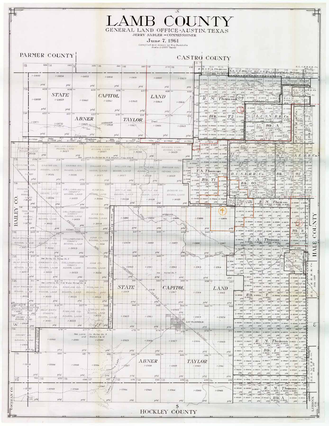
Lamb County Working Sketch Graphic Index
-
Map/Doc
76613
-
Collection
General Map Collection
-
Object Dates
6/7/1961 (Creation Date)
-
People and Organizations
Roy Buckholts (Draftsman)
-
Counties
Lamb
-
Subjects
County Surveying Working Sketch
-
Height x Width
43.8 x 34.1 inches
111.3 x 86.6 cm
-
Scale
1" = 2000 varas
Part of: General Map Collection
Crockett County Rolled Sketch 62

Print $20.00
- Digital $50.00
Crockett County Rolled Sketch 62
1947
Size 27.0 x 38.1 inches
Map/Doc 5605
Current Miscellaneous File 59

Print $16.00
- Digital $50.00
Current Miscellaneous File 59
1836
Size 11.4 x 8.9 inches
Map/Doc 74056
Dimmit County Sketch File 26

Print $6.00
- Digital $50.00
Dimmit County Sketch File 26
Size 13.5 x 10.2 inches
Map/Doc 21144
Val Verde County Working Sketch 56

Print $20.00
- Digital $50.00
Val Verde County Working Sketch 56
1957
Size 41.8 x 32.2 inches
Map/Doc 72191
Brown County Working Sketch 20

Print $20.00
- Digital $50.00
Brown County Working Sketch 20
2011
Size 32.8 x 34.8 inches
Map/Doc 89999
Flight Mission No. CUG-3P, Frame 166, Kleberg County

Print $20.00
- Digital $50.00
Flight Mission No. CUG-3P, Frame 166, Kleberg County
1956
Size 18.6 x 22.3 inches
Map/Doc 86286
Nueces County Rolled Sketch 65

Print $20.00
- Digital $50.00
Nueces County Rolled Sketch 65
1979
Size 19.5 x 26.2 inches
Map/Doc 6917
Gaines County Sketch File 23

Print $20.00
- Digital $50.00
Gaines County Sketch File 23
1964
Size 20.0 x 22.8 inches
Map/Doc 11529
Denton County Working Sketch 16

Print $20.00
- Digital $50.00
Denton County Working Sketch 16
1973
Size 31.5 x 39.1 inches
Map/Doc 68621
Travis County Rolled Sketch 37

Print $20.00
- Digital $50.00
Travis County Rolled Sketch 37
1942
Size 36.1 x 35.6 inches
Map/Doc 10014
Madison County Working Sketch 12

Print $40.00
- Digital $50.00
Madison County Working Sketch 12
1965
Size 41.7 x 48.5 inches
Map/Doc 70774
Dickens County Sketch File 27

Print $25.00
- Digital $50.00
Dickens County Sketch File 27
Size 14.4 x 8.9 inches
Map/Doc 20993
You may also like
La Salle County Rolled Sketch 28

Print $90.00
- Digital $50.00
La Salle County Rolled Sketch 28
1956
Size 51.1 x 49.1 inches
Map/Doc 9561
Crockett County Working Sketch 11
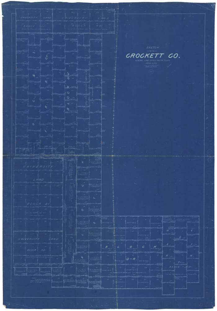
Print $40.00
- Digital $50.00
Crockett County Working Sketch 11
1913
Size 47.9 x 33.5 inches
Map/Doc 68344
Callahan County Working Sketch 6

Print $20.00
- Digital $50.00
Callahan County Working Sketch 6
1955
Size 30.2 x 18.8 inches
Map/Doc 67888
Harris County Rolled Sketch 73

Print $20.00
- Digital $50.00
Harris County Rolled Sketch 73
1947
Size 41.0 x 33.9 inches
Map/Doc 9133
Brewster County Sketch File N-26

Print $40.00
- Digital $50.00
Brewster County Sketch File N-26
Size 20.5 x 15.4 inches
Map/Doc 10971
Reagan County Rolled Sketch R

Print $20.00
- Digital $50.00
Reagan County Rolled Sketch R
Size 33.0 x 31.0 inches
Map/Doc 10734
Map of Kerr County

Print $20.00
- Digital $50.00
Map of Kerr County
1869
Size 22.2 x 32.1 inches
Map/Doc 3764
Schleicher County Sketch File 48

Print $4.00
- Digital $50.00
Schleicher County Sketch File 48
1953
Size 11.2 x 8.7 inches
Map/Doc 36558
Flight Mission No. DQN-3K, Frame 68, Calhoun County

Print $20.00
- Digital $50.00
Flight Mission No. DQN-3K, Frame 68, Calhoun County
1953
Size 18.5 x 22.3 inches
Map/Doc 84359
Baylor County Rolled Sketch BHK

Print $20.00
- Digital $50.00
Baylor County Rolled Sketch BHK
1892
Size 18.8 x 43.5 inches
Map/Doc 5130
Wharton County Sketch File 15

Print $20.00
- Digital $50.00
Wharton County Sketch File 15
Size 18.2 x 21.1 inches
Map/Doc 12665
Edwards County Rolled Sketch 23

Print $20.00
- Digital $50.00
Edwards County Rolled Sketch 23
1952
Size 26.3 x 34.7 inches
Map/Doc 8846