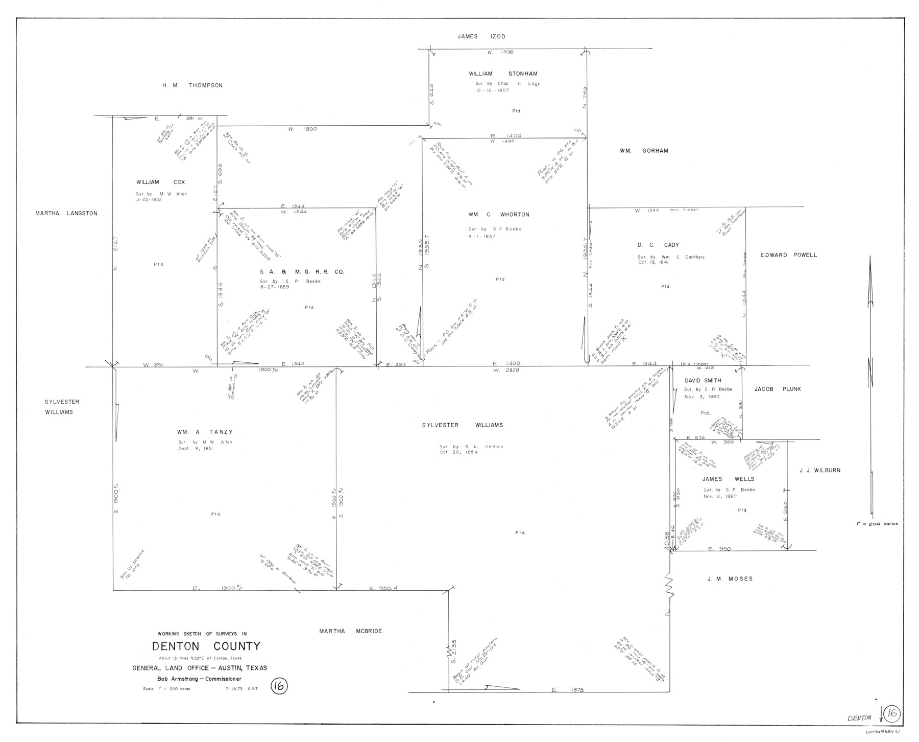
Denton County Working Sketch 16
-
Map/Doc
68621
-
Collection
General Map Collection
-
Object Dates
7/18/1973 (Creation Date)
-
People and Organizations
Abner G. Trigg (Draftsman)
-
Counties
Denton
-
Subjects
Surveying Working Sketch
-
Height x Width
31.5 x 39.1 inches
80.0 x 99.3 cm
-
Scale
1" = 200 varas
Part of: General Map Collection
Colorado County Working Sketch 9

Print $20.00
- Digital $50.00
Colorado County Working Sketch 9
1939
Size 12.0 x 15.7 inches
Map/Doc 68109
Harris County Rolled Sketch 88

Print $20.00
- Digital $50.00
Harris County Rolled Sketch 88
1937
Size 34.9 x 22.7 inches
Map/Doc 6126
Jasper County Boundary File 4

Print $4.00
- Digital $50.00
Jasper County Boundary File 4
Size 14.4 x 8.9 inches
Map/Doc 55489
Flight Mission No. BRA-16M, Frame 148, Jefferson County

Print $20.00
- Digital $50.00
Flight Mission No. BRA-16M, Frame 148, Jefferson County
1953
Size 18.5 x 22.2 inches
Map/Doc 85754
Fisher County Sketch File 15a

Print $10.00
- Digital $50.00
Fisher County Sketch File 15a
1901
Size 7.6 x 9.0 inches
Map/Doc 22578
Nueces County Sketch File 12c

Print $11.00
- Digital $50.00
Nueces County Sketch File 12c
1889
Size 12.6 x 8.2 inches
Map/Doc 32534
Dimmit County Sketch File 31

Print $20.00
- Digital $50.00
Dimmit County Sketch File 31
1894
Size 12.7 x 17.3 inches
Map/Doc 11352
Edwards County Working Sketch 48

Print $20.00
- Digital $50.00
Edwards County Working Sketch 48
1950
Size 46.3 x 38.2 inches
Map/Doc 68924
Fisher County Working Sketch 4

Print $20.00
- Digital $50.00
Fisher County Working Sketch 4
1926
Size 24.4 x 17.2 inches
Map/Doc 69138
Flight Mission No. BRA-16M, Frame 104, Jefferson County

Print $20.00
- Digital $50.00
Flight Mission No. BRA-16M, Frame 104, Jefferson County
1953
Size 18.5 x 22.3 inches
Map/Doc 85716
Flight Mission No. DQN-2K, Frame 191, Calhoun County

Print $20.00
- Digital $50.00
Flight Mission No. DQN-2K, Frame 191, Calhoun County
1953
Size 18.8 x 22.4 inches
Map/Doc 84332
Hood County Sketch File 21

Print $12.00
- Digital $50.00
Hood County Sketch File 21
1873
Size 7.8 x 6.7 inches
Map/Doc 26609
You may also like
Gregg County Sketch File 15

Print $6.00
- Digital $50.00
Gregg County Sketch File 15
1946
Size 14.3 x 8.8 inches
Map/Doc 24616
Sketch Showing Portion of League 4, Wilson County School Land, Lynn County, Texas

Print $20.00
- Digital $50.00
Sketch Showing Portion of League 4, Wilson County School Land, Lynn County, Texas
Size 13.5 x 13.0 inches
Map/Doc 92940
Polk County Working Sketch 20

Print $40.00
- Digital $50.00
Polk County Working Sketch 20
1952
Size 42.2 x 51.7 inches
Map/Doc 71635
Bailey County Sketch File 13

Print $40.00
- Digital $50.00
Bailey County Sketch File 13
1912
Size 19.2 x 20.6 inches
Map/Doc 10888
Upton County Working Sketch 16

Print $20.00
- Digital $50.00
Upton County Working Sketch 16
1941
Size 17.1 x 12.0 inches
Map/Doc 69512
Map of Texas Compiled from Surveys recorded in the Land Office of Texas

Print $20.00
- Digital $50.00
Map of Texas Compiled from Surveys recorded in the Land Office of Texas
1841
Size 26.4 x 22.3 inches
Map/Doc 538
Flight Mission No. CGI-3G, Frame 16, Cameron County

Print $20.00
- Digital $50.00
Flight Mission No. CGI-3G, Frame 16, Cameron County
1950
Size 18.5 x 18.3 inches
Map/Doc 84664
Section G Tech Memorial Park, Inc., Catholic Section

Print $20.00
- Digital $50.00
Section G Tech Memorial Park, Inc., Catholic Section
Size 18.0 x 30.8 inches
Map/Doc 92354
[Surveys along the Colorado River]
![112, [Surveys along the Colorado River], General Map Collection](https://historictexasmaps.com/wmedia_w700/maps/112.tif.jpg)
Print $2.00
- Digital $50.00
[Surveys along the Colorado River]
1841
Size 12.2 x 8.3 inches
Map/Doc 112
Chambers County Sketch File 15

Print $4.00
- Digital $50.00
Chambers County Sketch File 15
Size 8.3 x 12.4 inches
Map/Doc 17563
Sketch of Section 3, Blk. JW, Showing Quantity East of Each Texas Section

Print $20.00
- Digital $50.00
Sketch of Section 3, Blk. JW, Showing Quantity East of Each Texas Section
Size 34.2 x 8.0 inches
Map/Doc 91985
No. 2 Chart of Corpus Christi Pass, Texas

Print $20.00
- Digital $50.00
No. 2 Chart of Corpus Christi Pass, Texas
1878
Size 18.3 x 27.2 inches
Map/Doc 73028