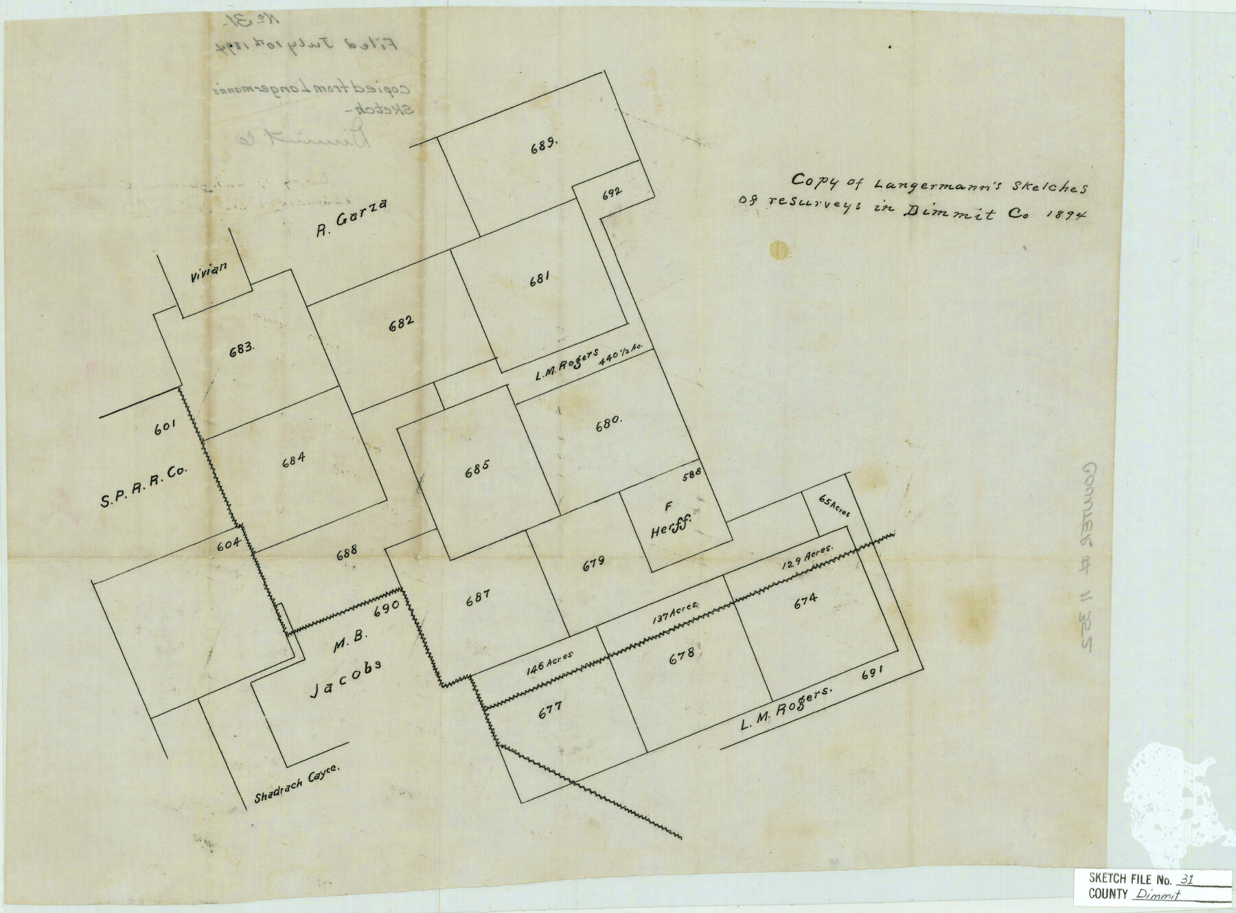
Dimmit County Sketch File 31
Copy of Langermann sketches of resurveys in Dimmit Co. 1894
-
Map/Doc
11352
-
Collection
General Map Collection
-
Object Dates
1894/7/10 (File Date)
1894 (Creation Date)
1894 (Survey Date)
-
Counties
Dimmit Zavala
-
Subjects
Surveying Sketch File
-
Height x Width
12.7 x 17.3 inches
32.3 x 43.9 cm
-
Medium
paper, manuscript
Part of: General Map Collection
Castro County Rolled Sketch 11

Print $20.00
- Digital $50.00
Castro County Rolled Sketch 11
1940
Size 20.2 x 25.3 inches
Map/Doc 5420
Presidio County Sketch File 63

Print $4.00
- Digital $50.00
Presidio County Sketch File 63
1939
Size 20.7 x 22.3 inches
Map/Doc 11718
Yoakum County Sketch File 18

Print $24.00
- Digital $50.00
Yoakum County Sketch File 18
1898
Size 11.5 x 9.0 inches
Map/Doc 40820
Brewster County Working Sketch 51

Print $40.00
- Digital $50.00
Brewster County Working Sketch 51
1950
Size 62.9 x 26.4 inches
Map/Doc 67585
Culberson County Sketch File 11a

Print $4.00
- Digital $50.00
Culberson County Sketch File 11a
1926
Size 14.3 x 8.7 inches
Map/Doc 20172
Newton County Working Sketch Graphic Index

Print $20.00
- Digital $50.00
Newton County Working Sketch Graphic Index
1946
Size 47.5 x 41.0 inches
Map/Doc 76653
Wise County Sketch File 10

Print $6.00
- Digital $50.00
Wise County Sketch File 10
1855
Size 7.6 x 8.2 inches
Map/Doc 40541
Flight Mission No. BQR-16K, Frame 33, Brazoria County

Print $20.00
- Digital $50.00
Flight Mission No. BQR-16K, Frame 33, Brazoria County
1952
Size 18.5 x 22.3 inches
Map/Doc 84100
Ride the Texas Independence Trail [Verso]
![94167, Ride the Texas Independence Trail [Verso], General Map Collection](https://historictexasmaps.com/wmedia_w700/maps/94167.tif.jpg)
Ride the Texas Independence Trail [Verso]
1968
Size 18.4 x 24.4 inches
Map/Doc 94167
McMullen County Sketch File 7

Print $40.00
- Digital $50.00
McMullen County Sketch File 7
1859
Size 19.1 x 11.6 inches
Map/Doc 31347
Matagorda Light to Aransas Pass

Print $20.00
- Digital $50.00
Matagorda Light to Aransas Pass
1946
Size 35.8 x 44.5 inches
Map/Doc 73394
Henderson County Working Sketch 16

Print $40.00
- Digital $50.00
Henderson County Working Sketch 16
1937
Size 49.9 x 30.9 inches
Map/Doc 66149
You may also like
Dallas County Sketch File 18a

Print $20.00
- Digital $50.00
Dallas County Sketch File 18a
Size 12.4 x 23.8 inches
Map/Doc 11286
General Highway Map, Nolan County, Texas

Print $20.00
General Highway Map, Nolan County, Texas
1940
Size 18.4 x 24.7 inches
Map/Doc 79208
Whiteface Cemetery

Print $20.00
- Digital $50.00
Whiteface Cemetery
Size 29.3 x 18.0 inches
Map/Doc 92525
Reagan County Working Sketch 28

Print $40.00
- Digital $50.00
Reagan County Working Sketch 28
1963
Size 55.7 x 42.4 inches
Map/Doc 71870
Old Miscellaneous File 16

Print $28.00
- Digital $50.00
Old Miscellaneous File 16
1908
Size 9.8 x 2.6 inches
Map/Doc 75457
Liberty County Working Sketch 66

Print $40.00
- Digital $50.00
Liberty County Working Sketch 66
1970
Size 42.9 x 49.9 inches
Map/Doc 70526
Kleberg County

Print $20.00
- Digital $50.00
Kleberg County
1913
Size 27.2 x 34.4 inches
Map/Doc 5006
Zapata County Rolled Sketch 10

Print $20.00
- Digital $50.00
Zapata County Rolled Sketch 10
1912
Size 25.4 x 26.6 inches
Map/Doc 8311
Reeves County Working Sketch 9

Print $20.00
- Digital $50.00
Reeves County Working Sketch 9
1948
Size 19.0 x 24.0 inches
Map/Doc 63452
Crockett County Working Sketch 75

Print $20.00
- Digital $50.00
Crockett County Working Sketch 75
1964
Size 25.7 x 24.0 inches
Map/Doc 68408
Flight Mission No. CLL-1N, Frame 112, Willacy County

Print $20.00
- Digital $50.00
Flight Mission No. CLL-1N, Frame 112, Willacy County
1954
Size 18.4 x 20.1 inches
Map/Doc 87046
Preliminary survey of the entrance to the Rio Grande, Texas

Print $20.00
- Digital $50.00
Preliminary survey of the entrance to the Rio Grande, Texas
1854
Size 18.2 x 22.6 inches
Map/Doc 94073