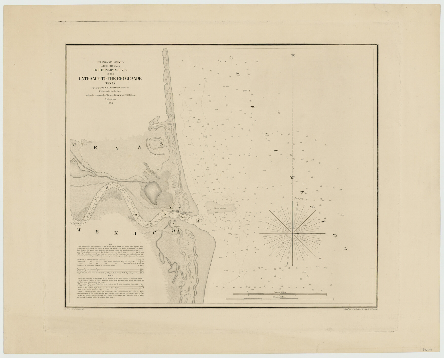
Preliminary survey of the entrance to the Rio Grande, Texas
-
Map/Doc
94073
-
Collection
General Map Collection
-
Object Dates
1854 (Creation Date)
-
People and Organizations
U.S. Coast Survey (Publisher)
C.A. Knight & App. F.W. Benner (Printer)
W.E. Greenwell (Draftsman)
W.E. Greenwell (Cartographer)
J. Wilkinson (Military Officer)
-
Subjects
Nautical Charts
-
Height x Width
18.2 x 22.6 inches
46.2 x 57.4 cm
-
Medium
paper, etching/engraving/lithograph
-
Scale
1:20,000
Part of: General Map Collection
Presidio County Working Sketch 69

Print $20.00
- Digital $50.00
Presidio County Working Sketch 69
1960
Size 33.3 x 41.3 inches
Map/Doc 71746
Jasper County

Print $40.00
- Digital $50.00
Jasper County
1898
Size 65.1 x 37.4 inches
Map/Doc 82048
Limestone County Working Sketch 20

Print $20.00
- Digital $50.00
Limestone County Working Sketch 20
1976
Size 41.5 x 42.3 inches
Map/Doc 70570
Dimmit County Sketch File 22

Print $47.00
- Digital $50.00
Dimmit County Sketch File 22
1906
Size 9.3 x 8.6 inches
Map/Doc 21129
Schleicher County

Print $40.00
- Digital $50.00
Schleicher County
1940
Size 39.7 x 55.9 inches
Map/Doc 95636
Garza County Sketch File 26

Print $4.00
- Digital $50.00
Garza County Sketch File 26
Size 10.9 x 8.5 inches
Map/Doc 24095

Polk County Sketch File 38

Print $20.00
- Digital $50.00
Polk County Sketch File 38
Size 13.9 x 8.8 inches
Map/Doc 34268
Maverick County Rolled Sketch 16

Print $20.00
- Digital $50.00
Maverick County Rolled Sketch 16
1887
Size 21.5 x 31.9 inches
Map/Doc 6709
El Paso County Sketch File 39

Print $27.00
- Digital $50.00
El Paso County Sketch File 39
1922
Size 13.9 x 8.8 inches
Map/Doc 22225
Rockwall County Boundary File 75a

Print $10.00
- Digital $50.00
Rockwall County Boundary File 75a
Size 13.0 x 8.2 inches
Map/Doc 58481

You may also like
Flight Mission No. CGI-3N, Frame 137, Cameron County

Print $20.00
- Digital $50.00
Flight Mission No. CGI-3N, Frame 137, Cameron County
1954
Size 18.6 x 22.2 inches
Map/Doc 84610
General Highway Map. Detail of Cities and Towns in Leon County, Texas

Print $20.00
General Highway Map. Detail of Cities and Towns in Leon County, Texas
1961
Size 18.1 x 24.8 inches
Map/Doc 79569
Houston Ship Channel, Alexander Island to Carpenter Bayou

Print $20.00
- Digital $50.00
Houston Ship Channel, Alexander Island to Carpenter Bayou
1971
Size 35.1 x 46.7 inches
Map/Doc 69907
San Jacinto County Working Sketch 44

Print $20.00
- Digital $50.00
San Jacinto County Working Sketch 44
1981
Size 20.6 x 11.4 inches
Map/Doc 63758
Terry County Working Sketch 1

Print $20.00
- Digital $50.00
Terry County Working Sketch 1
1938
Size 24.0 x 19.9 inches
Map/Doc 62106
Crockett County Working Sketch 88

Print $20.00
- Digital $50.00
Crockett County Working Sketch 88
1976
Size 34.0 x 32.9 inches
Map/Doc 68421
Clay County Sketch File 4

Print $22.00
- Digital $50.00
Clay County Sketch File 4
1854
Size 5.0 x 7.5 inches
Map/Doc 18392
[John Walker, south part B9 and vicinity]
![90330, [John Walker, south part B9 and vicinity], Twichell Survey Records](https://historictexasmaps.com/wmedia_w700/maps/90330-1.tif.jpg)
Print $20.00
- Digital $50.00
[John Walker, south part B9 and vicinity]
Size 32.7 x 24.1 inches
Map/Doc 90330
[Blocks 21, 22, 23, and 24]
![91110, [Blocks 21, 22, 23, and 24], Twichell Survey Records](https://historictexasmaps.com/wmedia_w700/maps/91110-1.tif.jpg)
Print $20.00
- Digital $50.00
[Blocks 21, 22, 23, and 24]
Size 14.0 x 12.8 inches
Map/Doc 91110
Crockett County Working Sketch 79

Print $40.00
- Digital $50.00
Crockett County Working Sketch 79
1973
Size 46.2 x 76.4 inches
Map/Doc 68412
La Salle County Working Sketch 24

Print $20.00
- Digital $50.00
La Salle County Working Sketch 24
1947
Size 20.9 x 31.2 inches
Map/Doc 70325
Foard County Sketch File 14

Print $4.00
- Digital $50.00
Foard County Sketch File 14
1885
Size 14.4 x 8.8 inches
Map/Doc 22819