El Paso County Sketch File 39
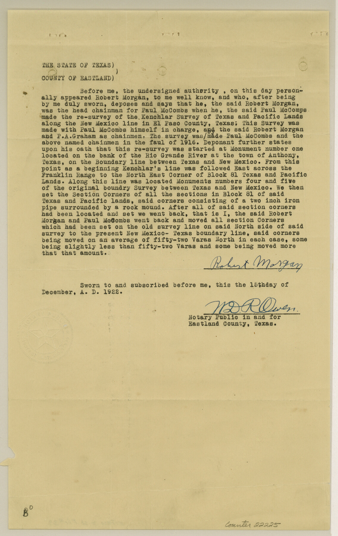
[Affidavits regarding surveys 3, 91, 174, 252, etc]
-
Map/Doc
22225
-
Collection
General Map Collection
-
Object Dates
1922/11/23 (Creation Date)
1922 (File Date)
1916 (Survey Date)
1922/12/16 (Survey Date)
1859 (Survey Date)
-
People and Organizations
W.L. Rider (Surveyor/Engineer)
Paul McCombs (Surveyor/Engineer)
Robert Morgan (Chainman)
P.A. Graham (Chainman)
Kenchlar (Surveyor/Engineer)
Carter (Surveyor/Engineer)
J.H. Clark (Surveyor/Engineer)
Jacob Kuechler (Surveyor/Engineer)
-
Counties
El Paso Hudspeth
-
Subjects
Surveying Sketch File
-
Height x Width
13.9 x 8.8 inches
35.3 x 22.4 cm
-
Medium
paper, print
-
Features
Rio Grande
Anthony
El Paso-Santa Cruz Road
Franklin Mountains
Hueco Mountains
El Paso, Rio Grande & Santa Fe RR
Upper Valley Road
El Paso
Courchesne Bridge
White Spur Station
Fort Handcock [sic]
Vinton
Part of: General Map Collection
Flight Mission No. DQN-6K, Frame 92, Calhoun County

Print $20.00
- Digital $50.00
Flight Mission No. DQN-6K, Frame 92, Calhoun County
1953
Size 18.6 x 22.3 inches
Map/Doc 84452
Kent County Working Sketch 22

Print $20.00
- Digital $50.00
Kent County Working Sketch 22
1987
Size 42.7 x 43.1 inches
Map/Doc 70029
Foard County Sketch File 36

Print $20.00
- Digital $50.00
Foard County Sketch File 36
Size 15.4 x 28.0 inches
Map/Doc 11498
San Augustine County Rolled Sketch 4

Print $20.00
- Digital $50.00
San Augustine County Rolled Sketch 4
2004
Size 24.5 x 36.7 inches
Map/Doc 83422
Ward County Working Sketch 20

Print $20.00
- Digital $50.00
Ward County Working Sketch 20
1949
Size 15.3 x 12.5 inches
Map/Doc 72326
Brazoria County Rolled Sketch 35

Print $40.00
- Digital $50.00
Brazoria County Rolled Sketch 35
1934
Size 32.7 x 60.0 inches
Map/Doc 8459
Hutchinson County Working Sketch 29

Print $20.00
- Digital $50.00
Hutchinson County Working Sketch 29
1978
Size 26.5 x 22.1 inches
Map/Doc 66389
Lamb County Sketch File 5

Print $20.00
- Digital $50.00
Lamb County Sketch File 5
Size 23.3 x 31.1 inches
Map/Doc 11971
Dimmit County Sketch File 22

Print $47.00
- Digital $50.00
Dimmit County Sketch File 22
1906
Size 9.3 x 8.6 inches
Map/Doc 21129
Matagorda County Sketch File 42a

Print $18.00
- Digital $50.00
Matagorda County Sketch File 42a
1914
Size 11.2 x 8.6 inches
Map/Doc 30853
Map of the State of Texas Showing Original Land Districts

Print $20.00
- Digital $50.00
Map of the State of Texas Showing Original Land Districts
1891
Size 42.2 x 42.4 inches
Map/Doc 2138
Armstrong County Working Sketch 5

Print $40.00
- Digital $50.00
Armstrong County Working Sketch 5
1918
Size 48.4 x 41.9 inches
Map/Doc 67236
You may also like
Brewster County Sketch File 50

Print $32.00
- Digital $50.00
Brewster County Sketch File 50
1995
Size 14.8 x 8.5 inches
Map/Doc 16336
T. C. Ivey Ranch, Block D, Yoakum Co., Texas

Print $20.00
- Digital $50.00
T. C. Ivey Ranch, Block D, Yoakum Co., Texas
Size 17.1 x 14.6 inches
Map/Doc 91976
Map of Jack County, State of Texas : exhibiting the extent of public surveys land grants and all other official information compiled from official surveys of the Genral Land Office at Austin…

Print $20.00
Map of Jack County, State of Texas : exhibiting the extent of public surveys land grants and all other official information compiled from official surveys of the Genral Land Office at Austin…
1876
Size 16.5 x 15.4 inches
Map/Doc 93591
[Sketch in Hutchinson County, Texas]
![4491, [Sketch in Hutchinson County, Texas], Maddox Collection](https://historictexasmaps.com/wmedia_w700/maps/4491.tif.jpg)
Print $20.00
- Digital $50.00
[Sketch in Hutchinson County, Texas]
Size 36.2 x 31.1 inches
Map/Doc 4491
Stonewall County Rolled Sketch 20

Print $40.00
- Digital $50.00
Stonewall County Rolled Sketch 20
1951
Size 30.1 x 55.4 inches
Map/Doc 63915
Surveys on the Coleto Creek, Goliad County

Print $20.00
- Digital $50.00
Surveys on the Coleto Creek, Goliad County
1841
Size 13.8 x 14.9 inches
Map/Doc 10
Foard County Sketch File 23

Print $20.00
- Digital $50.00
Foard County Sketch File 23
1891
Size 21.3 x 24.7 inches
Map/Doc 4544
El Paso County Working Sketch 21

Print $20.00
- Digital $50.00
El Paso County Working Sketch 21
1960
Size 37.8 x 30.9 inches
Map/Doc 69043
Starr County Rolled Sketch 22

Print $20.00
- Digital $50.00
Starr County Rolled Sketch 22
1919
Size 37.3 x 22.3 inches
Map/Doc 7806
Harris County Working Sketch 123

Print $20.00
- Digital $50.00
Harris County Working Sketch 123
1993
Size 19.5 x 17.0 inches
Map/Doc 66015
Right of Way and Track Map, the Missouri, Kansas and Texas Ry. of Texas - Henrietta Division

Print $20.00
- Digital $50.00
Right of Way and Track Map, the Missouri, Kansas and Texas Ry. of Texas - Henrietta Division
1918
Size 11.8 x 26.9 inches
Map/Doc 64754
Menard County Sketch File 3

Print $40.00
- Digital $50.00
Menard County Sketch File 3
Size 16.3 x 12.9 inches
Map/Doc 31488