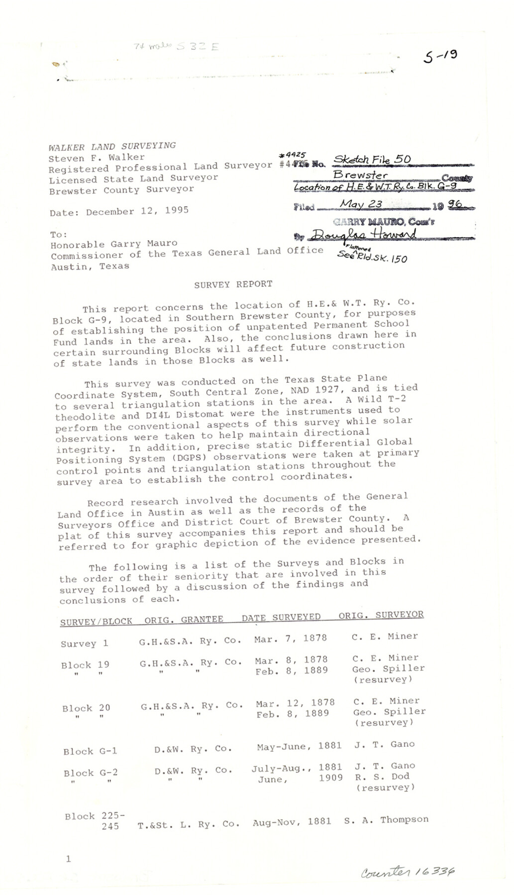
Brewster County Sketch File 50
[Report of location of H. E. & W. T. Ry. Co. Block G-9]
-
Map/Doc
16336
-
Collection
General Map Collection
-
Object Dates
1995/12/12 (Creation Date)
1996/5/22 (File Date)
-
People and Organizations
Steven F. Walker (Surveyor/Engineer)
-
Counties
Brewster
-
Subjects
Surveying Sketch File
-
Height x Width
14.8 x 8.5 inches
37.6 x 21.6 cm
-
Medium
paper, print
-
Comments
See Brewster County Rolled Sketch 150 (5317) for sketch.
-
Features
Maravillas Creek
Persimmon Gap
Highway 385
Pummel Peak
Tornillo Creek
Related maps
Brewster County Rolled Sketch 150

Print $20.00
- Digital $50.00
Brewster County Rolled Sketch 150
Size 36.4 x 25.1 inches
Map/Doc 5317
Part of: General Map Collection
Sherman County Sketch File 4

Print $4.00
- Digital $50.00
Sherman County Sketch File 4
1925
Size 8.7 x 5.8 inches
Map/Doc 36688
Palo Pinto County Working Sketch 11

Print $20.00
- Digital $50.00
Palo Pinto County Working Sketch 11
1942
Size 21.2 x 22.1 inches
Map/Doc 71394
Dawson County Sketch File 7

Print $20.00
- Digital $50.00
Dawson County Sketch File 7
1926
Size 20.0 x 24.6 inches
Map/Doc 11292
Blanco County Working Sketch 44

Print $20.00
- Digital $50.00
Blanco County Working Sketch 44
2000
Size 19.5 x 35.6 inches
Map/Doc 67404
Jefferson County Sketch File 47

Print $20.00
- Digital $50.00
Jefferson County Sketch File 47
1898
Size 27.2 x 19.1 inches
Map/Doc 11881
Crockett County Working Sketch 38

Print $20.00
- Digital $50.00
Crockett County Working Sketch 38
1928
Size 28.7 x 16.6 inches
Map/Doc 68371
[Sketch for Mineral Application 19560 - 19588 - San Bernard River]
![65662, [Sketch for Mineral Application 19560 - 19588 - San Bernard River], General Map Collection](https://historictexasmaps.com/wmedia_w700/maps/65662.tif.jpg)
Print $40.00
- Digital $50.00
[Sketch for Mineral Application 19560 - 19588 - San Bernard River]
Size 31.6 x 73.6 inches
Map/Doc 65662
Dickens County Rolled Sketch C

Print $20.00
- Digital $50.00
Dickens County Rolled Sketch C
1895
Size 20.5 x 25.5 inches
Map/Doc 5710
Falls of St. Anthony

Print $2.00
- Digital $50.00
Falls of St. Anthony
1810
Size 6.2 x 8.8 inches
Map/Doc 95152
Platt [sic] of Late Surveys on Carancahua, Jackson County
![78360, Platt [sic] of Late Surveys on Carancahua, Jackson County, General Map Collection](https://historictexasmaps.com/wmedia_w700/maps/78360.tif.jpg)
Print $2.00
- Digital $50.00
Platt [sic] of Late Surveys on Carancahua, Jackson County
Size 10.9 x 8.0 inches
Map/Doc 78360
Controlled Mosaic by Jack Amman Photogrammetric Engineers, Inc - Sheet 51

Print $20.00
- Digital $50.00
Controlled Mosaic by Jack Amman Photogrammetric Engineers, Inc - Sheet 51
1954
Size 20.0 x 24.0 inches
Map/Doc 83510
Sutton County Sketch File 26

Print $20.00
- Digital $50.00
Sutton County Sketch File 26
1929
Size 19.6 x 14.8 inches
Map/Doc 12383
You may also like
Jacob Kuechler's Field Notes (Field Book), Texas & Pacific Ry. Co. 80 Mile Reserve

Print $222.00
- Digital $50.00
Jacob Kuechler's Field Notes (Field Book), Texas & Pacific Ry. Co. 80 Mile Reserve
1879
Size 7.9 x 5.4 inches
Map/Doc 3050
Angelina County Rolled Sketch 1

Print $20.00
- Digital $50.00
Angelina County Rolled Sketch 1
Size 30.4 x 29.6 inches
Map/Doc 77184
Burleson County Working Sketch 39

Print $20.00
- Digital $50.00
Burleson County Working Sketch 39
1985
Size 15.3 x 18.7 inches
Map/Doc 67758
Location St. L. & S. W. R. R. Through Cherokee County

Print $40.00
- Digital $50.00
Location St. L. & S. W. R. R. Through Cherokee County
Size 108.6 x 39.0 inches
Map/Doc 64043
[Gulf Coast of Texas]
![72703, [Gulf Coast of Texas], General Map Collection](https://historictexasmaps.com/wmedia_w700/maps/72703.tif.jpg)
Print $20.00
- Digital $50.00
[Gulf Coast of Texas]
1881
Size 28.9 x 18.2 inches
Map/Doc 72703
Pecos County Rolled Sketch 166

Print $22.00
- Digital $50.00
Pecos County Rolled Sketch 166
Size 32.5 x 37.6 inches
Map/Doc 9747
Navigation Maps of Gulf Intracoastal Waterway, Port Arthur to Brownsville, Texas

Print $4.00
- Digital $50.00
Navigation Maps of Gulf Intracoastal Waterway, Port Arthur to Brownsville, Texas
1951
Size 16.6 x 21.3 inches
Map/Doc 65438
University Land Block 46, Culberson County, Texas

Print $20.00
- Digital $50.00
University Land Block 46, Culberson County, Texas
1938
Size 35.1 x 22.0 inches
Map/Doc 2410
Harris County Historic Topographic 13

Print $20.00
- Digital $50.00
Harris County Historic Topographic 13
1915
Size 29.1 x 22.6 inches
Map/Doc 65823
San Patricio County Working Sketch 2

Print $20.00
- Digital $50.00
San Patricio County Working Sketch 2
1911
Size 18.6 x 15.1 inches
Map/Doc 63764
Nueces County Rolled Sketch 44

Print $40.00
- Digital $50.00
Nueces County Rolled Sketch 44
1948
Size 40.0 x 60.8 inches
Map/Doc 9602
Grimes County Working Sketch 17

Print $20.00
- Digital $50.00
Grimes County Working Sketch 17
1996
Size 31.1 x 26.6 inches
Map/Doc 63308