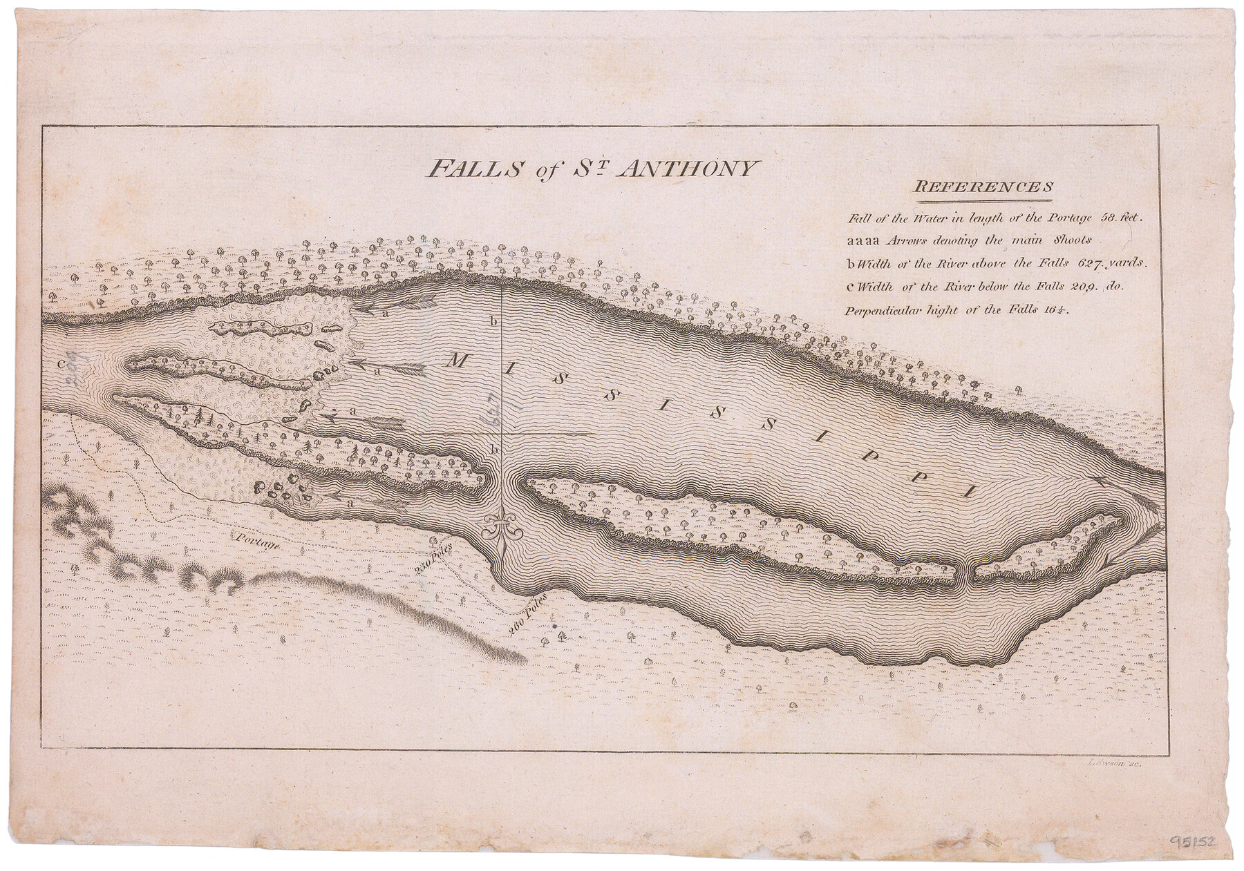
Falls of St. Anthony
-
Map/Doc
95152
-
Collection
General Map Collection
-
Object Dates
1810 (Creation Date)
-
People and Organizations
Lawson (Printer)
Zebulon Montgomery Pike (Explorer)
-
Subjects
Atlas
-
Height x Width
6.2 x 8.8 inches
15.7 x 22.4 cm
-
Medium
paper, etching/engraving/lithograph
-
Comments
From Pike's Expedition Atlas
-
URLs
https://medium.com/save-texas-history/texas-general-land-office-acquires-and-conserves-atlas-of-maps-made-by-captain-zebulon-m-pike-82f8e8375b28
Part of: General Map Collection
Oldham County Sketch File 1

Print $24.00
- Digital $50.00
Oldham County Sketch File 1
1880
Size 12.6 x 7.9 inches
Map/Doc 33213
Duval County Working Sketch 22

Print $20.00
- Digital $50.00
Duval County Working Sketch 22
1942
Size 21.9 x 26.0 inches
Map/Doc 68746
Harrison County Sketch File 6

Print $4.00
- Digital $50.00
Harrison County Sketch File 6
Size 12.9 x 8.1 inches
Map/Doc 26044
Travis County Rolled Sketch 43

Print $20.00
- Digital $50.00
Travis County Rolled Sketch 43
1962
Size 27.3 x 22.7 inches
Map/Doc 8041
Motley County Sketch File 18 (N)

Print $4.00
- Digital $50.00
Motley County Sketch File 18 (N)
1913
Size 11.3 x 8.7 inches
Map/Doc 32062
Sketch of a portion of the Texas Coast showing the relative positions of different harbours with the interior Military Posts, and the roads communicating with them, also two new routes from Black Point and Lamar to San Antonio

Print $20.00
- Digital $50.00
Sketch of a portion of the Texas Coast showing the relative positions of different harbours with the interior Military Posts, and the roads communicating with them, also two new routes from Black Point and Lamar to San Antonio
1855
Size 27.3 x 18.3 inches
Map/Doc 72710
Matagorda County Sketch File 37

Print $4.00
- Digital $50.00
Matagorda County Sketch File 37
Size 11.3 x 8.8 inches
Map/Doc 30830


Travis County

Print $20.00
- Digital $50.00
Travis County
1895
Size 47.8 x 46.4 inches
Map/Doc 82079
Grayson County Working Sketch 26

Print $20.00
- Digital $50.00
Grayson County Working Sketch 26
1984
Size 27.7 x 38.8 inches
Map/Doc 63265
Wise County Sketch File 22

Print $4.00
- Digital $50.00
Wise County Sketch File 22
1860
Size 7.5 x 7.2 inches
Map/Doc 40566
You may also like
Bird's Eye View of El Paso

Print $20.00
Bird's Eye View of El Paso
1885
Size 20.0 x 30.0 inches
Map/Doc 93621

Gradient Boundary Survey of Canadian River through portions of Hutchinson & Roberts Counties, Texas

Print $40.00
- Digital $50.00
Gradient Boundary Survey of Canadian River through portions of Hutchinson & Roberts Counties, Texas
1989
Size 39.6 x 139.0 inches
Map/Doc 3120
Harris County Rolled Sketch 42

Print $20.00
- Digital $50.00
Harris County Rolled Sketch 42
1919
Size 15.7 x 19.5 inches
Map/Doc 6100
Gray County Boundary File 3a

Print $4.00
- Digital $50.00
Gray County Boundary File 3a
Size 14.2 x 8.8 inches
Map/Doc 53874
Coleman County Sketch File 47

Print $12.00
- Digital $50.00
Coleman County Sketch File 47
1897
Size 14.1 x 8.6 inches
Map/Doc 18793
Hardeman County Sketch File 15

Print $20.00
- Digital $50.00
Hardeman County Sketch File 15
Size 18.9 x 17.9 inches
Map/Doc 11627
Coast of Texas and its defences

Print $20.00
- Digital $50.00
Coast of Texas and its defences
Size 27.8 x 18.2 inches
Map/Doc 72684
Reeves County

Print $20.00
- Digital $50.00
Reeves County
1915
Size 23.6 x 29.8 inches
Map/Doc 92896
Terre Nove (verso)

Print $20.00
- Digital $50.00
Terre Nove (verso)
1522
Size 12.2 x 7.8 inches
Map/Doc 93802
Flight Mission No. CUG-1P, Frame 168, Kleberg County

Print $20.00
- Digital $50.00
Flight Mission No. CUG-1P, Frame 168, Kleberg County
1956
Size 18.6 x 22.2 inches
Map/Doc 86175
Preliminary Sketch of Galveston Bay, Texas

Print $20.00
Preliminary Sketch of Galveston Bay, Texas
1852
Size 22.6 x 18.3 inches
Map/Doc 79317