Matagorda County Sketch File 37
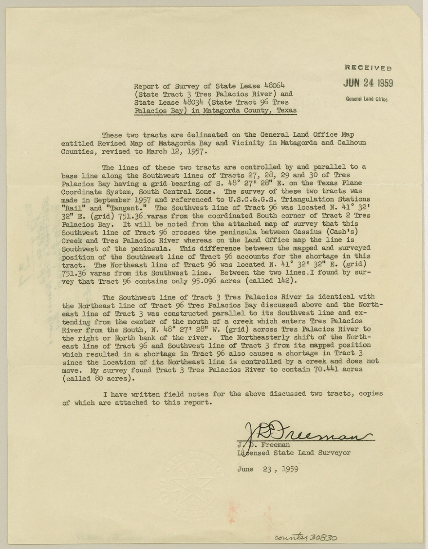
[Report of survey of State Lease 48064 and State Lease 48034, (State tracts 3 and 96, Tres Palacios)]
-
Map/Doc
30830
-
Collection
General Map Collection
-
Object Dates
8/3/1959 (File Date)
-
People and Organizations
J.D. Freeman (Surveyor/Engineer)
-
Counties
Matagorda
-
Subjects
Surveying Sketch File
-
Height x Width
11.3 x 8.8 inches
28.7 x 22.4 cm
-
Medium
paper, print
-
Features
Tres Palacios Bay
Tres Palacios River
Cash's Creek
Cassius Creek
Part of: General Map Collection
Culberson County Sketch File 7

Print $8.00
- Digital $50.00
Culberson County Sketch File 7
1888
Size 14.5 x 8.8 inches
Map/Doc 20138
Harris County Rolled Sketch P57

Print $20.00
- Digital $50.00
Harris County Rolled Sketch P57
1929
Size 29.6 x 37.5 inches
Map/Doc 9118
Pecos County Rolled Sketch 90

Print $20.00
- Digital $50.00
Pecos County Rolled Sketch 90
1934
Size 26.7 x 33.9 inches
Map/Doc 7245
Harris County Sketch File AA-1

Print $20.00
- Digital $50.00
Harris County Sketch File AA-1
Size 19.0 x 26.1 inches
Map/Doc 11646
Stonewall County Boundary File 4a

Print $18.00
- Digital $50.00
Stonewall County Boundary File 4a
Size 14.2 x 8.8 inches
Map/Doc 58984
Pecos County Working Sketch 78

Print $20.00
- Digital $50.00
Pecos County Working Sketch 78
1960
Size 29.4 x 34.4 inches
Map/Doc 71550
Dallas County Boundary File 6d

Print $104.00
- Digital $50.00
Dallas County Boundary File 6d
Size 14.2 x 8.6 inches
Map/Doc 52229
Castro County Rolled Sketch 11

Print $20.00
- Digital $50.00
Castro County Rolled Sketch 11
1940
Size 20.2 x 25.3 inches
Map/Doc 5420
Lamb County Sketch File 8

Print $6.00
- Digital $50.00
Lamb County Sketch File 8
1904
Size 8.5 x 7.6 inches
Map/Doc 29355
Map of DeWitt County

Print $20.00
- Digital $50.00
Map of DeWitt County
1853
Size 21.5 x 25.5 inches
Map/Doc 3479
Reeves County Working Sketch 62

Print $20.00
- Digital $50.00
Reeves County Working Sketch 62
1984
Size 29.5 x 35.4 inches
Map/Doc 63505
Liberty County Sketch File 52

Print $20.00
- Digital $50.00
Liberty County Sketch File 52
Size 17.5 x 13.5 inches
Map/Doc 11995
You may also like
Fisher County Sketch File 9

Print $4.00
- Digital $50.00
Fisher County Sketch File 9
1893
Size 11.1 x 8.5 inches
Map/Doc 22575
Flight Mission No. CRC-3R, Frame 29, Chambers County

Print $20.00
- Digital $50.00
Flight Mission No. CRC-3R, Frame 29, Chambers County
1956
Size 18.6 x 22.3 inches
Map/Doc 84804
Tourists' Handbook Descriptive of Colorado, New Mexico and Utah

Tourists' Handbook Descriptive of Colorado, New Mexico and Utah
1898
Size 9.4 x 6.4 inches
Map/Doc 97075
Rio Grande, Hargill Sheet

Print $20.00
- Digital $50.00
Rio Grande, Hargill Sheet
1937
Size 37.3 x 37.8 inches
Map/Doc 65109
Current Miscellaneous File 41

Print $8.00
- Digital $50.00
Current Miscellaneous File 41
Size 8.2 x 10.8 inches
Map/Doc 73977
Flight Mission No. CZW-2R, Frame 25, Hardeman County

Print $20.00
- Digital $50.00
Flight Mission No. CZW-2R, Frame 25, Hardeman County
1956
Size 18.7 x 22.4 inches
Map/Doc 85237
Reeves County Working Sketch 33

Print $20.00
- Digital $50.00
Reeves County Working Sketch 33
1970
Size 39.9 x 45.7 inches
Map/Doc 63476
Hudspeth County Sketch File 15

Print $9.00
- Digital $50.00
Hudspeth County Sketch File 15
1927
Size 14.3 x 8.8 inches
Map/Doc 26944
Runnels County Sketch File 38

Print $20.00
Runnels County Sketch File 38
1891
Size 17.6 x 24.9 inches
Map/Doc 12269
Right of Way and Track Map International & Gt Northern Ry. operated by the International & Gt. Northern Ry. Co., San Antonio Division

Print $40.00
- Digital $50.00
Right of Way and Track Map International & Gt Northern Ry. operated by the International & Gt. Northern Ry. Co., San Antonio Division
1917
Size 25.9 x 57.5 inches
Map/Doc 64588
Brazoria County Sketch File 18

Print $18.00
- Digital $50.00
Brazoria County Sketch File 18
Size 14.5 x 8.9 inches
Map/Doc 14989
Flight Mission No. CRC-3R, Frame 34, Chambers County

Print $20.00
- Digital $50.00
Flight Mission No. CRC-3R, Frame 34, Chambers County
1956
Size 18.5 x 22.3 inches
Map/Doc 84807