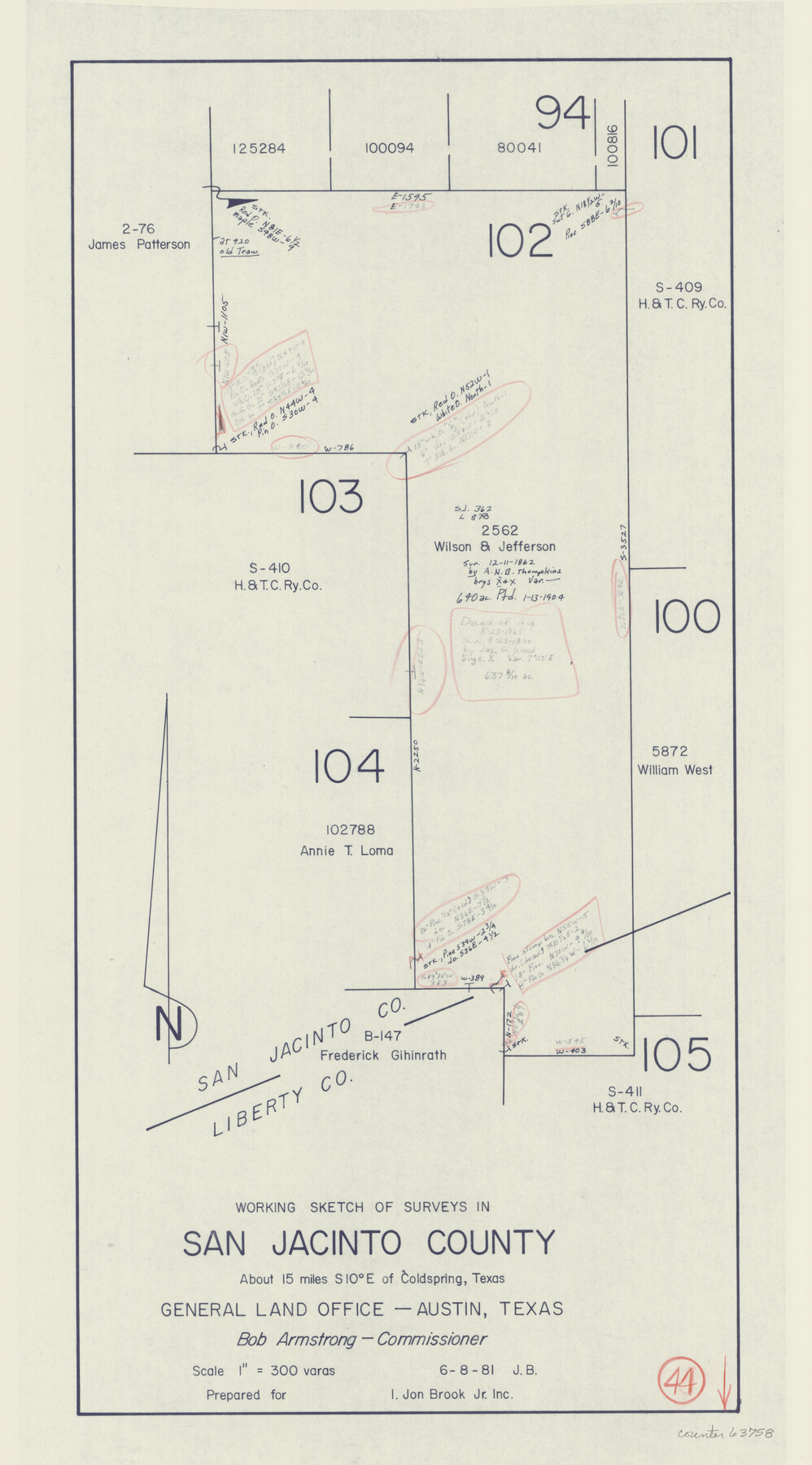
San Jacinto County Working Sketch 44
-
Map/Doc
63758
-
Collection
General Map Collection
-
Object Dates
6/8/1981 (Creation Date)
-
People and Organizations
Jana Brod (Draftsman)
-
Counties
San Jacinto
-
Subjects
Surveying Working Sketch
-
Height x Width
20.6 x 11.4 inches
52.3 x 29.0 cm
-
Scale
1" = 300 varas
Part of: General Map Collection
Comanche County Working Sketch 23

Print $20.00
- Digital $50.00
Comanche County Working Sketch 23
1974
Size 15.7 x 24.7 inches
Map/Doc 68157
Jefferson County Rolled Sketch 12

Print $2.00
- Digital $50.00
Jefferson County Rolled Sketch 12
Size 10.6 x 8.2 inches
Map/Doc 76004
Tom Green County

Print $40.00
- Digital $50.00
Tom Green County
1942
Size 55.4 x 47.6 inches
Map/Doc 63073
Jefferson County NRC Article 33.136 Sketch 14

Print $164.00
- Digital $50.00
Jefferson County NRC Article 33.136 Sketch 14
2021
Map/Doc 96645

Montgomery County Working Sketch 25

Print $40.00
- Digital $50.00
Montgomery County Working Sketch 25
1941
Size 50.0 x 43.7 inches
Map/Doc 71132
Reeves County Working Sketch Graphic Index

Print $20.00
- Digital $50.00
Reeves County Working Sketch Graphic Index
1945
Size 47.3 x 38.1 inches
Map/Doc 76682
Angelina County Sketch File 16a

Print $62.00
- Digital $50.00
Angelina County Sketch File 16a
1862
Size 6.0 x 8.3 inches
Map/Doc 13009
Hood County Boundary File 40

Print $44.00
- Digital $50.00
Hood County Boundary File 40
Size 14.4 x 8.8 inches
Map/Doc 55019

Zavala County Sketch File 42

Print $20.00
- Digital $50.00
Zavala County Sketch File 42
1915
Size 19.4 x 25.6 inches
Map/Doc 12732
Gregg County Boundary File 8

Print $8.00
- Digital $50.00
Gregg County Boundary File 8
Size 14.0 x 8.6 inches
Map/Doc 54019
You may also like
[Blocks 24, O, J, and L]
![92651, [Blocks 24, O, J, and L], Twichell Survey Records](https://historictexasmaps.com/wmedia_w700/maps/92651-1.tif.jpg)
Print $20.00
- Digital $50.00
[Blocks 24, O, J, and L]
Size 39.3 x 26.6 inches
Map/Doc 92651
Wise County Working Sketch 31

Print $20.00
- Digital $50.00
Wise County Working Sketch 31
2009
Size 27.9 x 37.5 inches
Map/Doc 89985
Moore County Sketch File 3

Print $20.00
- Digital $50.00
Moore County Sketch File 3
Size 17.2 x 19.3 inches
Map/Doc 42126
Archer County Sketch File 8

Print $40.00
- Digital $50.00
Archer County Sketch File 8
Size 40.9 x 31.5 inches
Map/Doc 10336
El Paso County Rolled Sketch 46A

Print $20.00
- Digital $50.00
El Paso County Rolled Sketch 46A
1937
Size 35.1 x 30.2 inches
Map/Doc 5833

Map of Matagorda County

Print $20.00
- Digital $50.00
Map of Matagorda County
1865
Size 32.8 x 28.4 inches
Map/Doc 3843
[Southwest corner of Runnels County School Land League 3]
![91586, [Southwest corner of Runnels County School Land League 3], Twichell Survey Records](https://historictexasmaps.com/wmedia_w700/maps/91586-1.tif.jpg)
Print $2.00
- Digital $50.00
[Southwest corner of Runnels County School Land League 3]
1927
Size 14.2 x 8.7 inches
Map/Doc 91586
Crosbyton (Jeff Williams Plan)

Print $20.00
- Digital $50.00
Crosbyton (Jeff Williams Plan)
Size 26.0 x 18.2 inches
Map/Doc 92126
St. Louis, Brownsville & Mexico Railway Location Map from Mile 100 to Mile 120

Print $40.00
- Digital $50.00
St. Louis, Brownsville & Mexico Railway Location Map from Mile 100 to Mile 120
1905
Size 19.4 x 67.8 inches
Map/Doc 64168
Hockley County Sketch File 15

Print $6.00
- Digital $50.00
Hockley County Sketch File 15
1912
Size 11.4 x 8.9 inches
Map/Doc 26550
Donley County Rolled Sketch 2

Print $20.00
- Digital $50.00
Donley County Rolled Sketch 2
Size 41.8 x 34.3 inches
Map/Doc 8800