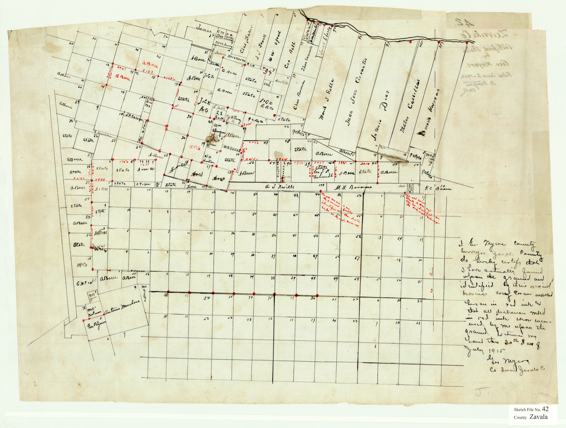
Zavala County Sketch File 42
[Sketch of surveys in the southeast part of the county south of the Leona River]
-
Map/Doc
12732
-
Collection
General Map Collection
-
Object Dates
7/30/1915 (Creation Date)
6/2/1922 (File Date)
-
People and Organizations
George Myers (Surveyor/Engineer)
-
Counties
Zavala Dimmit
-
Subjects
Surveying Sketch File
-
Height x Width
19.4 x 25.6 inches
49.3 x 65.0 cm
-
Medium
paper, manuscript
Part of: General Map Collection
Bandera County Sketch File 3

Print $6.00
- Digital $50.00
Bandera County Sketch File 3
1848
Size 11.6 x 10.3 inches
Map/Doc 13999
Parker County Working Sketch 12

Print $20.00
- Digital $50.00
Parker County Working Sketch 12
1974
Map/Doc 71462
Overlay For Flight Mission No. BRE-2P, Frame 110 of H. A. Pierce Corrected Survey, December 21, 1950 of Cyrus Egery Survey of June 15, 1855

Print $20.00
- Digital $50.00
Overlay For Flight Mission No. BRE-2P, Frame 110 of H. A. Pierce Corrected Survey, December 21, 1950 of Cyrus Egery Survey of June 15, 1855
1956
Size 18.3 x 20.4 inches
Map/Doc 86795
Presidio County Working Sketch 127

Print $20.00
- Digital $50.00
Presidio County Working Sketch 127
1987
Size 42.8 x 29.5 inches
Map/Doc 71805
North Sulphur River, Bartley Gin Sheet

Print $20.00
- Digital $50.00
North Sulphur River, Bartley Gin Sheet
1928
Size 13.3 x 22.0 inches
Map/Doc 78323
Hudspeth County Rolled Sketch 41

Print $40.00
- Digital $50.00
Hudspeth County Rolled Sketch 41
1947
Size 12.6 x 83.1 inches
Map/Doc 76043
Stonewall County Rolled Sketch 21

Print $40.00
- Digital $50.00
Stonewall County Rolled Sketch 21
1953
Size 50.8 x 47.9 inches
Map/Doc 9960
Flight Mission No. DQN-2K, Frame 143, Calhoun County

Print $20.00
- Digital $50.00
Flight Mission No. DQN-2K, Frame 143, Calhoun County
1953
Size 18.7 x 22.3 inches
Map/Doc 84312
Liberty County Working Sketch 90

Print $20.00
- Digital $50.00
Liberty County Working Sketch 90
2001
Size 23.1 x 43.1 inches
Map/Doc 70550
Nacogdoches County

Print $20.00
- Digital $50.00
Nacogdoches County
1950
Size 47.0 x 43.1 inches
Map/Doc 73248
Jefferson County Rolled Sketch 61G

Print $20.00
- Digital $50.00
Jefferson County Rolled Sketch 61G
1928
Size 27.2 x 40.3 inches
Map/Doc 6416
Cottle County Sketch File 7

Print $20.00
- Digital $50.00
Cottle County Sketch File 7
1893
Size 22.1 x 20.7 inches
Map/Doc 11191
You may also like
Flight Mission No. CUG-1P, Frame 48, Kleberg County

Print $20.00
- Digital $50.00
Flight Mission No. CUG-1P, Frame 48, Kleberg County
1956
Size 18.5 x 22.3 inches
Map/Doc 86126
The Republic County of Liberty. January 20, 1841

Print $20.00
The Republic County of Liberty. January 20, 1841
2020
Size 19.9 x 21.7 inches
Map/Doc 96209
General Highway Map, Brewster County, Texas

Print $20.00
General Highway Map, Brewster County, Texas
1940
Size 18.5 x 25.1 inches
Map/Doc 79028
Post Route Map of the State of Texas showing post offices with the intermediate distances on mail routes in operation on the 1st of March, 1907

Print $40.00
- Digital $50.00
Post Route Map of the State of Texas showing post offices with the intermediate distances on mail routes in operation on the 1st of March, 1907
1907
Size 50.1 x 68.0 inches
Map/Doc 2090
Mexico, California and Texas

Print $20.00
Mexico, California and Texas
1850
Size 11.1 x 15.0 inches
Map/Doc 82964
Ownership Map Hockley County, Texas

Print $20.00
- Digital $50.00
Ownership Map Hockley County, Texas
Size 19.1 x 20.4 inches
Map/Doc 92208
Dallas County Working Sketch 2

Print $20.00
- Digital $50.00
Dallas County Working Sketch 2
1917
Size 18.2 x 19.0 inches
Map/Doc 68568
Cooke County Boundary File 19

Print $30.00
- Digital $50.00
Cooke County Boundary File 19
Size 8.7 x 4.0 inches
Map/Doc 51858
Flight Mission No. DQN-1K, Frame 121, Calhoun County

Print $20.00
- Digital $50.00
Flight Mission No. DQN-1K, Frame 121, Calhoun County
1953
Size 18.6 x 22.2 inches
Map/Doc 84187
Webb County Sketch File X

Print $32.00
- Digital $50.00
Webb County Sketch File X
1908
Size 11.2 x 9.0 inches
Map/Doc 39701
Lipscomb County Working Sketch 1

Print $20.00
- Digital $50.00
Lipscomb County Working Sketch 1
1964
Size 30.7 x 34.1 inches
Map/Doc 70577
Eberstadt and Brock's Subdivisions of the West Half of Survey Number 187 Block 2 A. B. & M., Randall County Texas

Print $20.00
- Digital $50.00
Eberstadt and Brock's Subdivisions of the West Half of Survey Number 187 Block 2 A. B. & M., Randall County Texas
Size 14.9 x 30.7 inches
Map/Doc 91747