Cottle County Sketch File 7
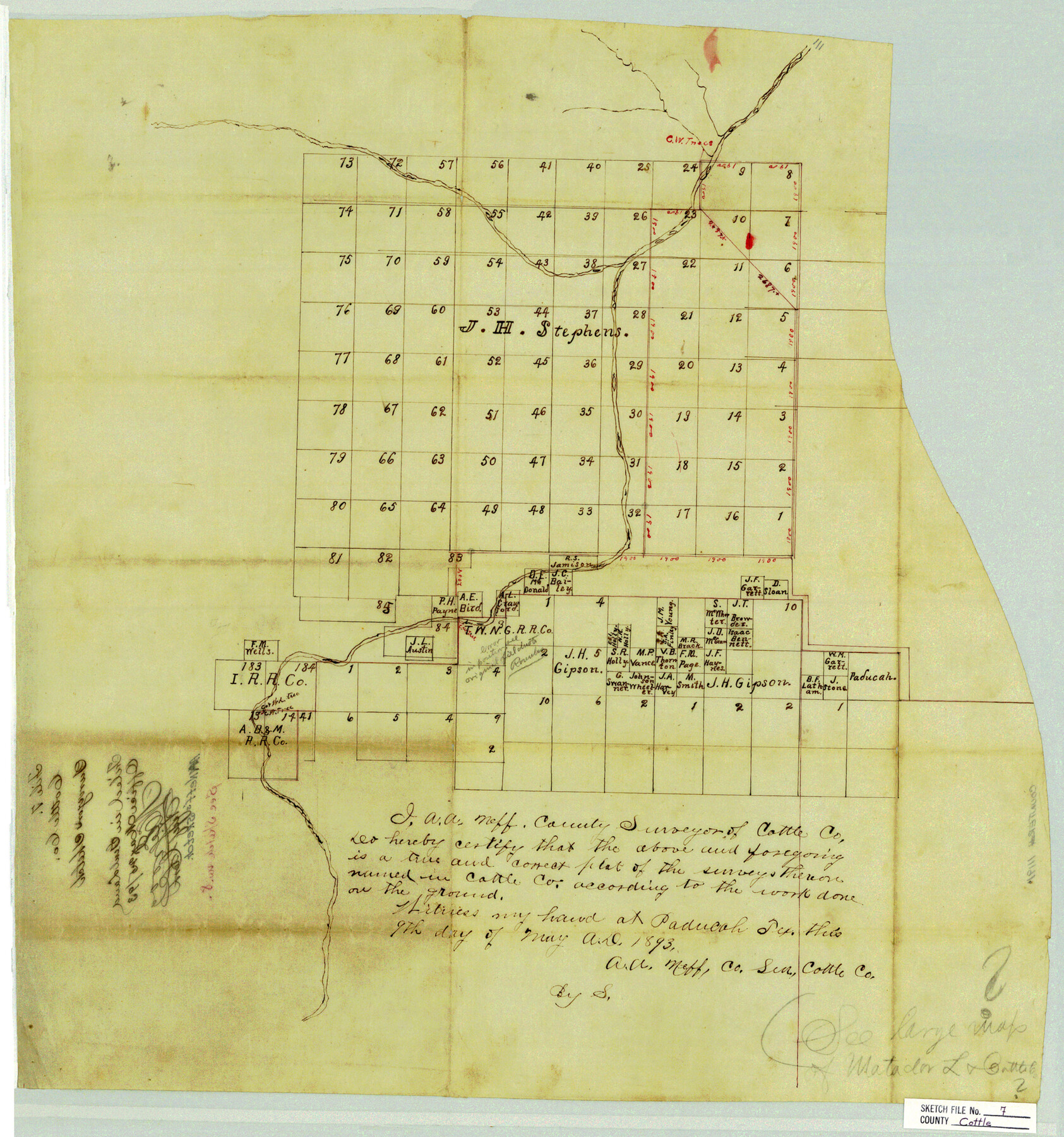
[Sketch of the J.H. Stephens Block and surveys to the south, west from Paducah]
-
Map/Doc
11191
-
Collection
General Map Collection
-
Object Dates
5/9/1893 (Creation Date)
5/25/1893 (File Date)
-
People and Organizations
A.A. Neff (Surveyor/Engineer)
-
Counties
Cottle Motley
-
Subjects
Surveying Sketch File
-
Height x Width
22.1 x 20.7 inches
56.1 x 52.6 cm
-
Medium
paper, manuscript
Part of: General Map Collection
La Salle County Sketch File 38

Print $40.00
- Digital $50.00
La Salle County Sketch File 38
Size 13.7 x 14.5 inches
Map/Doc 29590
Blanco County Working Sketch 22

Print $20.00
- Digital $50.00
Blanco County Working Sketch 22
1962
Size 41.0 x 36.5 inches
Map/Doc 67382
Glasscock County

Print $20.00
- Digital $50.00
Glasscock County
1933
Size 46.2 x 38.6 inches
Map/Doc 95508
Goliad County Working Sketch 16

Print $20.00
- Digital $50.00
Goliad County Working Sketch 16
1949
Size 30.0 x 46.9 inches
Map/Doc 63206
Current Miscellaneous File 114

Print $16.00
- Digital $50.00
Current Miscellaneous File 114
1985
Size 8.9 x 11.3 inches
Map/Doc 74803
San Jacinto County Rolled Sketch 14

Print $20.00
- Digital $50.00
San Jacinto County Rolled Sketch 14
1998
Size 28.1 x 40.0 inches
Map/Doc 7564
Map of Val Verde County

Print $40.00
- Digital $50.00
Map of Val Verde County
1898
Size 80.7 x 42.7 inches
Map/Doc 16913
Roberts County Working Sketch 34

Print $20.00
- Digital $50.00
Roberts County Working Sketch 34
1978
Size 26.6 x 22.5 inches
Map/Doc 63560
Surveyors report on resurvey of Capitol Leagues in three parts, also copy of judgement of the District Court, Travis County

Print $20.00
- Digital $50.00
Surveyors report on resurvey of Capitol Leagues in three parts, also copy of judgement of the District Court, Travis County
Size 12.3 x 15.8 inches
Map/Doc 62579
Austin County Sketch File 17

Print $4.00
- Digital $50.00
Austin County Sketch File 17
1873
Size 5.9 x 8.3 inches
Map/Doc 13925
Fayette County Working Sketch 6

Print $20.00
- Digital $50.00
Fayette County Working Sketch 6
1981
Size 17.0 x 15.1 inches
Map/Doc 69170
Hamilton County Rolled Sketch 9

Print $20.00
- Digital $50.00
Hamilton County Rolled Sketch 9
1903
Size 32.8 x 30.4 inches
Map/Doc 9098
You may also like
Terrell County Working Sketch 21

Print $20.00
- Digital $50.00
Terrell County Working Sketch 21
1935
Size 24.0 x 17.9 inches
Map/Doc 62171
Hale County Boundary File 6

Print $40.00
- Digital $50.00
Hale County Boundary File 6
Size 37.9 x 6.8 inches
Map/Doc 54073
Crosby County Boundary File 5a

Print $60.00
- Digital $50.00
Crosby County Boundary File 5a
Size 8.0 x 35.4 inches
Map/Doc 52044
Presidio County Working Sketch 15

Print $20.00
- Digital $50.00
Presidio County Working Sketch 15
1942
Size 38.1 x 41.3 inches
Map/Doc 71691
Newton County Working Sketch 40

Print $20.00
- Digital $50.00
Newton County Working Sketch 40
1970
Size 43.6 x 39.7 inches
Map/Doc 71286

Flight Mission No. BQR-3K, Frame 84, Brazoria County

Print $20.00
- Digital $50.00
Flight Mission No. BQR-3K, Frame 84, Brazoria County
1952
Size 18.8 x 22.5 inches
Map/Doc 83976
Map of North America engraved to illustrate Mitchell's school and family geography

Print $20.00
- Digital $50.00
Map of North America engraved to illustrate Mitchell's school and family geography
1839
Size 11.8 x 9.5 inches
Map/Doc 93493
Nueces County NRC Article 33.136 Location Key Sheet

Print $20.00
- Digital $50.00
Nueces County NRC Article 33.136 Location Key Sheet
1975
Size 27.0 x 23.0 inches
Map/Doc 88585
La Salle County Working Sketch 28

Print $20.00
- Digital $50.00
La Salle County Working Sketch 28
1954
Size 36.8 x 37.8 inches
Map/Doc 70329
Harris County Historic Topographic 27

Print $20.00
- Digital $50.00
Harris County Historic Topographic 27
1915
Size 19.8 x 23.5 inches
Map/Doc 65838
Newton County Working Sketch 37

Print $20.00
- Digital $50.00
Newton County Working Sketch 37
1960
Size 31.7 x 22.7 inches
Map/Doc 71283