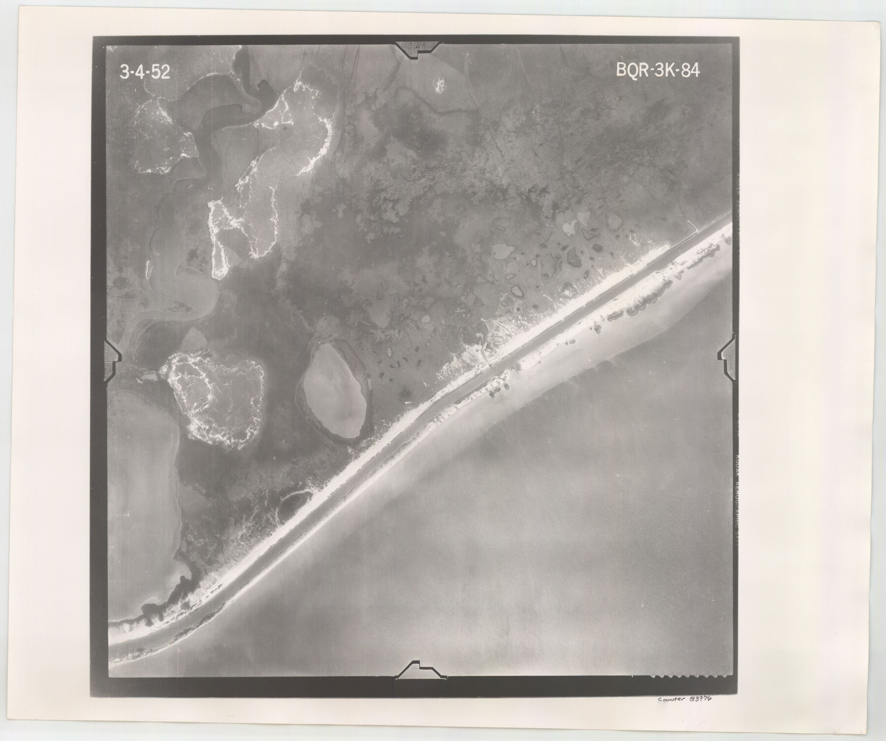
Flight Mission No. BQR-3K, Frame 84, Brazoria County
BQR-3K-84
-
Map/Doc
83976
-
Collection
General Map Collection
-
Object Dates
1952/3/4 (Creation Date)
-
People and Organizations
U. S. Department of Agriculture (Publisher)
-
Counties
Brazoria
-
Subjects
Aerial Photograph
-
Height x Width
18.8 x 22.5 inches
47.8 x 57.2 cm
-
Comments
Flown by Aero Exploration Company of Tulsa, Oklahoma.
Part of: General Map Collection
Presidio County Sketch File 91

Print $40.00
- Digital $50.00
Presidio County Sketch File 91
Size 12.3 x 15.9 inches
Map/Doc 34763
Austin Map and Street Guide [Recto]
![94162, Austin Map and Street Guide [Recto], General Map Collection](https://historictexasmaps.com/wmedia_w700/maps/94162.tif.jpg)
Austin Map and Street Guide [Recto]
1976
Size 35.4 x 22.7 inches
Map/Doc 94162
No. 3 Chart of Channel connecting Corpus Christi Bay with Aransas Bay, Texas

Print $20.00
- Digital $50.00
No. 3 Chart of Channel connecting Corpus Christi Bay with Aransas Bay, Texas
1878
Size 18.4 x 28.0 inches
Map/Doc 72775
Crockett County Working Sketch 65

Print $20.00
- Digital $50.00
Crockett County Working Sketch 65
1957
Size 32.3 x 38.0 inches
Map/Doc 68398
Amistad International Reservoir on Rio Grande 72a

Print $20.00
- Digital $50.00
Amistad International Reservoir on Rio Grande 72a
1949
Size 28.3 x 39.6 inches
Map/Doc 73361
Hamilton County Rolled Sketch 14

Print $20.00
- Digital $50.00
Hamilton County Rolled Sketch 14
1989
Size 28.0 x 40.0 inches
Map/Doc 6063
Coke County Sketch File 6

Print $6.00
- Digital $50.00
Coke County Sketch File 6
1860
Size 7.5 x 10.0 inches
Map/Doc 18582
Cottle County Working Sketch 19

Print $20.00
- Digital $50.00
Cottle County Working Sketch 19
1978
Size 33.2 x 29.3 inches
Map/Doc 68329
Jefferson County Aerial Photograph Index Sheet 1

Print $20.00
- Digital $50.00
Jefferson County Aerial Photograph Index Sheet 1
1953
Size 23.3 x 16.8 inches
Map/Doc 83707
McMullen County Rolled Sketch 7

Print $40.00
- Digital $50.00
McMullen County Rolled Sketch 7
1939
Size 38.8 x 51.7 inches
Map/Doc 9500
Dépt. des Basses-Alpes

Print $20.00
- Digital $50.00
Dépt. des Basses-Alpes
Size 13.9 x 20.3 inches
Map/Doc 94450
Live Oak County Sketch File 21

Print $26.00
- Digital $50.00
Live Oak County Sketch File 21
1912
Size 16.8 x 8.0 inches
Map/Doc 30297
You may also like
Hunt County Boundary File 49

Print $44.00
- Digital $50.00
Hunt County Boundary File 49
Size 9.1 x 5.2 inches
Map/Doc 55279
Webb County Sketch File 5a

Print $8.00
- Digital $50.00
Webb County Sketch File 5a
1877
Size 12.9 x 8.2 inches
Map/Doc 39729
General Highway Map, Chambers County, Texas

Print $20.00
General Highway Map, Chambers County, Texas
1961
Size 18.3 x 24.8 inches
Map/Doc 79404
[Central Part of County]
![89959, [Central Part of County], Twichell Survey Records](https://historictexasmaps.com/wmedia_w700/maps/89959-1.tif.jpg)
Print $40.00
- Digital $50.00
[Central Part of County]
Size 63.1 x 34.7 inches
Map/Doc 89959
Map of Hopkins County

Print $20.00
- Digital $50.00
Map of Hopkins County
1872
Size 17.5 x 17.9 inches
Map/Doc 4567
Flight Mission No. DQN-2K, Frame 159, Calhoun County

Print $20.00
- Digital $50.00
Flight Mission No. DQN-2K, Frame 159, Calhoun County
1953
Size 18.5 x 22.2 inches
Map/Doc 84321
Delta County Working Sketch 2

Print $20.00
- Digital $50.00
Delta County Working Sketch 2
1963
Size 26.6 x 25.2 inches
Map/Doc 68639
Menard County Working Sketch 29

Print $20.00
- Digital $50.00
Menard County Working Sketch 29
1967
Size 25.8 x 32.0 inches
Map/Doc 70976
Brazos River Entrance

Print $20.00
- Digital $50.00
Brazos River Entrance
1925
Size 31.0 x 41.4 inches
Map/Doc 69974
Dimmit County Working Sketch 27

Print $20.00
- Digital $50.00
Dimmit County Working Sketch 27
1956
Size 20.3 x 23.0 inches
Map/Doc 68688
Die Neüwen Inseln / so hinder Hispanien gegen Orient bey dem Landt Indie ligen

Print $20.00
- Digital $50.00
Die Neüwen Inseln / so hinder Hispanien gegen Orient bey dem Landt Indie ligen
1540
Size 12.3 x 15.6 inches
Map/Doc 93803
East Part of Jeff Davis Co.

Print $20.00
- Digital $50.00
East Part of Jeff Davis Co.
1977
Size 40.6 x 30.9 inches
Map/Doc 77327