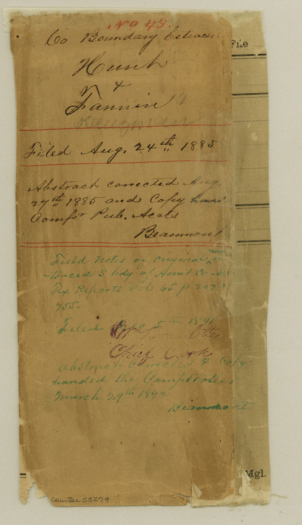
Hunt County Boundary File 49
Hunt and Fannin Co. Line Certified Copy
-
Map/Doc
55279
-
Collection
General Map Collection
-
Counties
Hunt
-
Subjects
County Boundaries
-
Height x Width
9.1 x 5.2 inches
23.1 x 13.2 cm
Part of: General Map Collection
Orange County Working Sketch 27

Print $20.00
- Digital $50.00
Orange County Working Sketch 27
1953
Size 31.0 x 22.9 inches
Map/Doc 71359
University Lands Blocks 1 to 11 Andrews-Martin-Gaines-Dawson-Winkler Counties

Print $6.00
- Digital $50.00
University Lands Blocks 1 to 11 Andrews-Martin-Gaines-Dawson-Winkler Counties
Size 30.9 x 35.3 inches
Map/Doc 62930
Flight Mission No. BRA-7M, Frame 139, Jefferson County

Print $20.00
- Digital $50.00
Flight Mission No. BRA-7M, Frame 139, Jefferson County
1953
Size 18.7 x 22.4 inches
Map/Doc 85533
Coryell County Sketch File 14

Print $6.00
- Digital $50.00
Coryell County Sketch File 14
1873
Size 5.0 x 7.6 inches
Map/Doc 19368
Map showing the line of march of the Centre Division, Army of Mexico, under the command of Brigr. Genl. John E. Wool, from San Antonio de Bexar, Texas to Saltillo, Mexico

Print $20.00
- Digital $50.00
Map showing the line of march of the Centre Division, Army of Mexico, under the command of Brigr. Genl. John E. Wool, from San Antonio de Bexar, Texas to Saltillo, Mexico
1846
Size 24.5 x 19.5 inches
Map/Doc 94074
Donley County Sketch File B10

Print $24.00
- Digital $50.00
Donley County Sketch File B10
1938
Size 14.3 x 9.1 inches
Map/Doc 21272
Galveston County Sketch File 18

Print $4.00
- Digital $50.00
Galveston County Sketch File 18
Size 5.5 x 8.0 inches
Map/Doc 23388
Township 3 South Range 12 West, South Western District, Louisiana

Print $20.00
- Digital $50.00
Township 3 South Range 12 West, South Western District, Louisiana
1879
Size 19.5 x 24.8 inches
Map/Doc 65883
Flight Mission No. CRC-4R, Frame 152, Chambers County

Print $20.00
- Digital $50.00
Flight Mission No. CRC-4R, Frame 152, Chambers County
1956
Size 18.8 x 22.4 inches
Map/Doc 84915
Hutchinson County Rolled Sketch 37

Print $20.00
- Digital $50.00
Hutchinson County Rolled Sketch 37
1950
Size 24.4 x 44.4 inches
Map/Doc 6296
Current Miscellaneous File 76

Print $10.00
- Digital $50.00
Current Miscellaneous File 76
1960
Size 11.3 x 8.8 inches
Map/Doc 74189
Atascosa County Sketch File 11

Print $4.00
- Digital $50.00
Atascosa County Sketch File 11
1856
Size 10.8 x 8.6 inches
Map/Doc 13767
You may also like
Flight Mission No. DIX-10P, Frame 83, Aransas County

Print $20.00
- Digital $50.00
Flight Mission No. DIX-10P, Frame 83, Aransas County
1956
Size 18.7 x 22.3 inches
Map/Doc 83944
Coleman County

Print $20.00
- Digital $50.00
Coleman County
1858
Size 25.2 x 22.5 inches
Map/Doc 3409
Liberty County Sketch File 42

Print $4.00
- Digital $50.00
Liberty County Sketch File 42
Size 7.0 x 10.0 inches
Map/Doc 29998
General Highway Map. Detail of Cities and Towns in Fort Bend County, Texas

Print $20.00
General Highway Map. Detail of Cities and Towns in Fort Bend County, Texas
1961
Size 18.1 x 24.5 inches
Map/Doc 79470
Martin County Working Sketch 17

Print $20.00
- Digital $50.00
Martin County Working Sketch 17
1981
Size 32.4 x 41.4 inches
Map/Doc 70835
General Highway Map Supplementary Sheet Showing Detail of Cities and Towns in Bexar County Texas

Print $20.00
General Highway Map Supplementary Sheet Showing Detail of Cities and Towns in Bexar County Texas
1936
Size 18.5 x 25.0 inches
Map/Doc 76290
Mason County Working Sketch 8

Print $20.00
- Digital $50.00
Mason County Working Sketch 8
1946
Size 22.9 x 32.3 inches
Map/Doc 70844
Nueces County Rolled Sketch 58

Print $50.00
Nueces County Rolled Sketch 58
1979
Size 28.2 x 40.1 inches
Map/Doc 6899
[William Steele Survey near Copano Bay]
![60285, [William Steele Survey near Copano Bay], General Map Collection](https://historictexasmaps.com/wmedia_w700/maps/60285-1.tif.jpg)
Print $3.00
- Digital $50.00
[William Steele Survey near Copano Bay]
1927
Size 14.9 x 9.8 inches
Map/Doc 60285
Willacy County Boundary File 1

Print $23.00
- Digital $50.00
Willacy County Boundary File 1
Size 11.3 x 8.8 inches
Map/Doc 59956
Aransas Pass to Baffin Bay

Print $20.00
- Digital $50.00
Aransas Pass to Baffin Bay
1976
Size 41.9 x 35.3 inches
Map/Doc 73419
United States - Gulf Coast Texas - Southern part of Laguna Madre

Print $20.00
- Digital $50.00
United States - Gulf Coast Texas - Southern part of Laguna Madre
1941
Size 26.8 x 18.3 inches
Map/Doc 72946