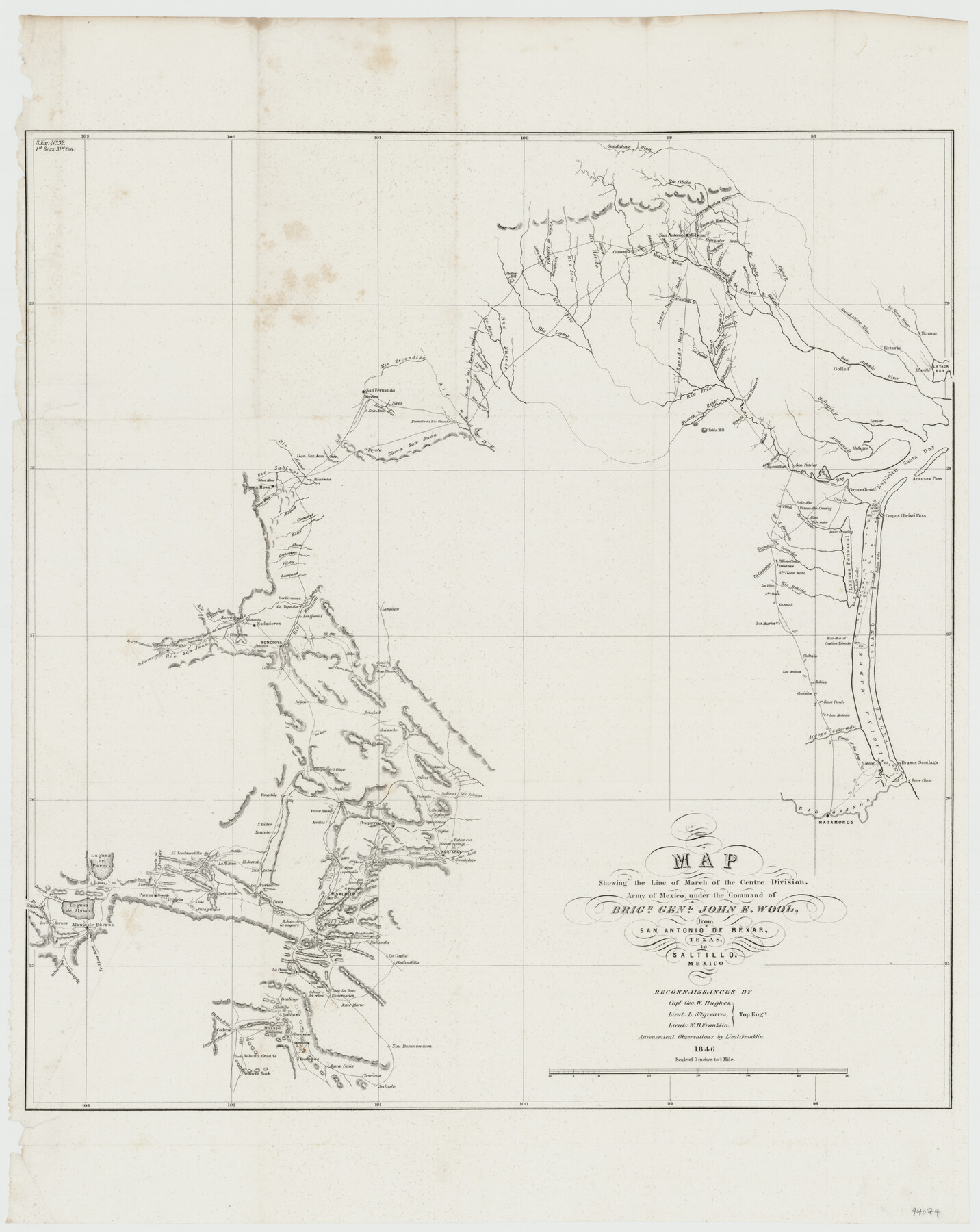
Map showing the line of march of the Centre Division, Army of Mexico, under the command of Brigr. Genl. John E. Wool, from San Antonio de Bexar, Texas to Saltillo, Mexico
-
Map/Doc
94074
-
Collection
General Map Collection
-
Object Dates
1846 (Creation Date)
-
People and Organizations
Geo. W. Hughes (Surveyor/Engineer)
L. Sitgreaves (Surveyor/Engineer)
W.B. Franklin (Surveyor/Engineer)
-
Subjects
Mexico Military
-
Height x Width
24.5 x 19.5 inches
62.2 x 49.5 cm
-
Medium
paper, etching/engraving/lithograph
-
Scale
5 inches to 1 mile
-
Comments
Astronomical Observations by Lieut. Franklin.
-
Features
Rio Grande
Boca Chica Pass
Brasos Santiago Pass
Point Isabel
Arroyo Colorado
Matamoros
Route of the Army
Los Mulatos
Laguna Madre
Padre Island
Saus Ponds
Carisitos Pond
Tahitos Pond
Los Animos Pond
Rancho of Gastine Tolendo
Los Muertos Pond
Encinal Pond
Santa Rosa Pond
La Pita
Rio Bobido
Santa Clara Motte
Laguna Penascal
Salt Lake
Belederos Pond
Pelican Ponds
[Road] to Camargo
Escondido Creek
Santa Gertrudis Creek
Rio San Fernando
Ague Dulce Creek
Indian Wells
Assan Crossing
Corpus Christi Pass
Palo Alto
Petronella Crossing
Almo Creek
Osa Creek
Los Pintos Creek
Aransas Pass
Espiritu Santo Bay
Refugio
Nueces Bay
San Patricio
Aransas River
Lamar
Refugio River
Lipantitlan
Casa Blanca Creek
Bass Creek
Cane Creek
Table Hill
Nueces River
Puente Piedras Creek
San Cristoval Creek
Rio Frio
Goliad
San Antonio River
Linville
Lavaca Bay
Victoria
Texana
Lavaca River
Guadalupe River
Chacanatilla Creek
Lepan Creek
Laha Creek
La Parita
Loredo [sic] Road
Lower Presidio Road
Boraga Creek
Cat Creek
Tortilla Creek
Atascosa River
Medina River
Road to Victoria & Goliad
Cieto River
Rio Cibolo
Marcelinas Creek
Gonzales Road
Leon Creek
Medio Creek
San Antonio de Bejar
Pinaritos Creek
Eagle Creek
Charpedra Creek
Calaverde Creek
Seguin Road
Salado Creek
Petrania Creek
Nacogdoches Road
Castroville
Ludy's Creek
Rio Hondo
Rio Seco
Rancheros Creek
Sabinal River
Canon River
Little Sabinal River
Padron Hill
Rio Leona
La Mina Creek
Route of the Centre Division
Saladina Creek
Picoso Creek
Chaparoso Creek
Las Cuevas Creek
Rio Escondido
San Fernando
Moretos
Nova
Santa Rita Creek
San Juan
Peyote
Sierra San Juan
Llan [sic] San Juan
Rio Alamo
Rio Sabinos
Silver Mine
Santa Rosa
Silver Mine Creek
Alamos Creek
Carecitos Creek
Saus Creek
Ahura Creek
Gachupina Creek
Piletes Creek
Part of: General Map Collection
San Augustine County Sketch File 10

Print $4.00
San Augustine County Sketch File 10
Size 12.8 x 8.1 inches
Map/Doc 35652
Austin County Sketch File 4a

Print $8.00
- Digital $50.00
Austin County Sketch File 4a
1881
Size 6.5 x 4.9 inches
Map/Doc 13861
Nueces County Rolled Sketch 69
Print $20.00
- Digital $50.00
Nueces County Rolled Sketch 69
Size 23.8 x 33.0 inches
Map/Doc 6920
[Surveys in the Montgomery District: San Jacinto River and Caney Creek, Navidad, Navasota]
![33, [Surveys in the Montgomery District: San Jacinto River and Caney Creek, Navidad, Navasota], General Map Collection](https://historictexasmaps.com/wmedia_w700/maps/33.tif.jpg)
Print $2.00
- Digital $50.00
[Surveys in the Montgomery District: San Jacinto River and Caney Creek, Navidad, Navasota]
1846
Size 8.8 x 6.0 inches
Map/Doc 33

Floyd County Sketch File 15

Print $12.00
- Digital $50.00
Floyd County Sketch File 15
1913
Size 10.9 x 7.3 inches
Map/Doc 22736
Dickens County Rolled Sketch P1

Print $20.00
- Digital $50.00
Dickens County Rolled Sketch P1
1915
Size 40.5 x 36.2 inches
Map/Doc 8783
San Patricio County Sketch File 25

Print $4.00
San Patricio County Sketch File 25
1875
Size 10.8 x 7.0 inches
Map/Doc 36083
Presidio County Sketch File G

Print $6.00
- Digital $50.00
Presidio County Sketch File G
1913
Size 9.7 x 17.0 inches
Map/Doc 34429
Wise County Sketch File 53

Print $12.00
- Digital $50.00
Wise County Sketch File 53
2007
Size 8.5 x 14.0 inches
Map/Doc 87360
Chambers County Sketch File 13

Print $6.00
- Digital $50.00
Chambers County Sketch File 13
1873
Size 9.8 x 12.4 inches
Map/Doc 17558
Bandera County Rolled Sketch 3

Print $20.00
- Digital $50.00
Bandera County Rolled Sketch 3
1947
Size 29.3 x 35.8 inches
Map/Doc 5115
You may also like
San Benito, Texas on the Frisco in the Lower Rio Grande Valley

San Benito, Texas on the Frisco in the Lower Rio Grande Valley
1911
Map/Doc 96727
Harris County Working Sketch 77

Print $20.00
- Digital $50.00
Harris County Working Sketch 77
1967
Size 28.6 x 24.0 inches
Map/Doc 65969
Edwards County Working Sketch 127

Print $20.00
- Digital $50.00
Edwards County Working Sketch 127
1980
Size 21.0 x 24.1 inches
Map/Doc 69003
Schleicher County Working Sketch 20
Print $20.00
- Digital $50.00
Schleicher County Working Sketch 20
1951
Size 33.8 x 21.2 inches
Map/Doc 63822
Leon County Rolled Sketch 21

Print $20.00
- Digital $50.00
Leon County Rolled Sketch 21
Size 33.5 x 24.3 inches
Map/Doc 75971
Taylor County Rolled Sketch 27

Print $20.00
- Digital $50.00
Taylor County Rolled Sketch 27
Size 37.5 x 30.3 inches
Map/Doc 7918
Galveston County NRC Article 33.136 Sketch 74

Print $26.00
- Digital $50.00
Galveston County NRC Article 33.136 Sketch 74
2013
Size 24.0 x 36.0 inches
Map/Doc 95114
Flight Mission No. DAG-28K, Frame 24, Matagorda County

Print $20.00
- Digital $50.00
Flight Mission No. DAG-28K, Frame 24, Matagorda County
1953
Size 16.2 x 16.0 inches
Map/Doc 86592
De Loache's Subdivision County School Leagues Hockley County, Texas

Print $20.00
- Digital $50.00
De Loache's Subdivision County School Leagues Hockley County, Texas
1924
Size 38.6 x 36.8 inches
Map/Doc 92235
PSL Field Notes for Blocks G, L, P, and Q in Cochran and Yoakum Counties and Blocks U, V, W, Y, and Z in Cochran County

PSL Field Notes for Blocks G, L, P, and Q in Cochran and Yoakum Counties and Blocks U, V, W, Y, and Z in Cochran County
Map/Doc 81645
Starr County Rolled Sketch X

Print $121.00
- Digital $50.00
Starr County Rolled Sketch X
Size 13.3 x 8.1 inches
Map/Doc 75961
Flight Mission No. BRE-1P, Frame 117, Nueces County

Print $20.00
- Digital $50.00
Flight Mission No. BRE-1P, Frame 117, Nueces County
1956
Size 18.4 x 22.3 inches
Map/Doc 86683