Leon County Rolled Sketch 21
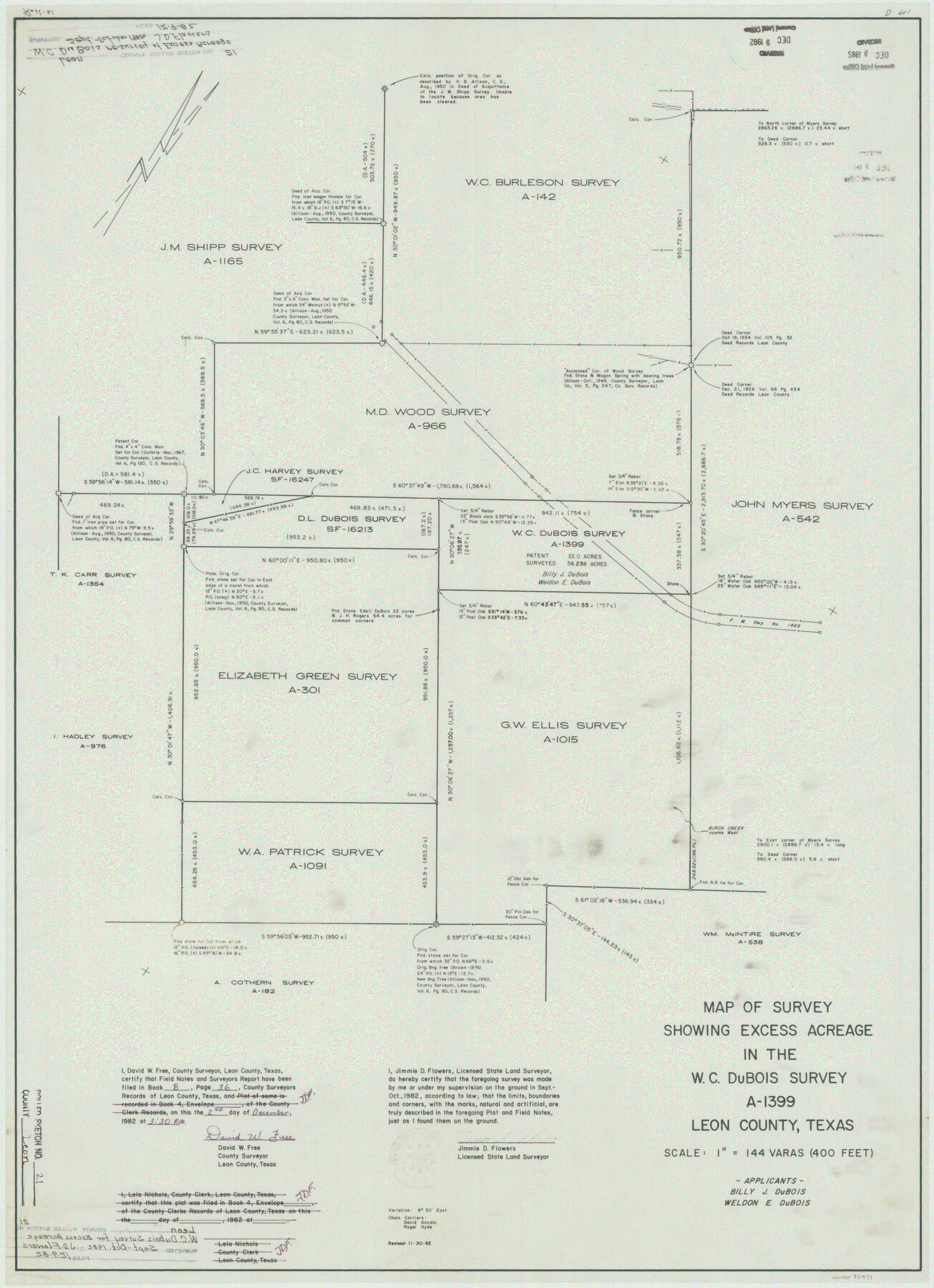
Map of survey showing excess acreage in the W.C. DuBois survey A-1399, Leon County, Texas
-
Map/Doc
75971
-
Collection
General Map Collection
-
Object Dates
1982 (Survey Date)
1982/12/9 (File Date)
1982/11/30 (Revision Date)
-
People and Organizations
Jimmie D. Flowers (Surveyor/Engineer)
-
Counties
Leon
-
Subjects
Surveying Rolled Sketch
-
Height x Width
33.5 x 24.3 inches
85.1 x 61.7 cm
-
Medium
mylar, print
-
Scale
1" = 144 varas
Part of: General Map Collection
Wilson County Sketch File 4

Print $28.00
- Digital $50.00
Wilson County Sketch File 4
1851
Size 8.4 x 7.7 inches
Map/Doc 40404
Roberts County Boundary File 2e

Print $20.00
- Digital $50.00
Roberts County Boundary File 2e
Size 28.3 x 8.8 inches
Map/Doc 58367
Crockett County Sketch File 93

Print $8.00
- Digital $50.00
Crockett County Sketch File 93
1887
Size 12.7 x 8.2 inches
Map/Doc 19946
Anderson County Working Sketch 24

Print $20.00
- Digital $50.00
Anderson County Working Sketch 24
1917
Size 16.6 x 15.3 inches
Map/Doc 67024
Plat of Resurvey of Sections 13, 24, 25 and 26, T. 5S., R. 12W., of the Indian Meridian, Oklahoma

Print $4.00
- Digital $50.00
Plat of Resurvey of Sections 13, 24, 25 and 26, T. 5S., R. 12W., of the Indian Meridian, Oklahoma
1917
Size 18.3 x 24.1 inches
Map/Doc 75158
Presidio County Rolled Sketch T-3

Print $20.00
- Digital $50.00
Presidio County Rolled Sketch T-3
Size 36.6 x 28.9 inches
Map/Doc 7417
Cherokee County Sketch File 31

Print $6.00
- Digital $50.00
Cherokee County Sketch File 31
1934
Size 14.0 x 8.9 inches
Map/Doc 18184
Harrison County Rolled Sketch 11

Print $20.00
- Digital $50.00
Harrison County Rolled Sketch 11
1957
Size 24.7 x 30.2 inches
Map/Doc 6154
Sherman County Boundary File 2

Print $34.00
- Digital $50.00
Sherman County Boundary File 2
Size 13.0 x 9.0 inches
Map/Doc 58761
Flight Mission No. DQO-8K, Frame 84, Galveston County

Print $20.00
- Digital $50.00
Flight Mission No. DQO-8K, Frame 84, Galveston County
1952
Size 18.6 x 22.5 inches
Map/Doc 85186
Culberson County Sketch File 44

Print $57.00
- Digital $50.00
Culberson County Sketch File 44
1968
Size 11.4 x 8.9 inches
Map/Doc 20331
Irion County Rolled Sketch 10

Print $20.00
- Digital $50.00
Irion County Rolled Sketch 10
1942
Size 29.8 x 29.1 inches
Map/Doc 6322
You may also like
Flight Mission No. DIX-5P, Frame 138, Aransas County

Print $20.00
- Digital $50.00
Flight Mission No. DIX-5P, Frame 138, Aransas County
1956
Size 17.7 x 17.9 inches
Map/Doc 83799

[Surveys along the Sabine River made under G.W. Smyth, Commissioner]
![89, [Surveys along the Sabine River made under G.W. Smyth, Commissioner], General Map Collection](https://historictexasmaps.com/wmedia_w700/maps/89.tif.jpg)
Print $20.00
- Digital $50.00
[Surveys along the Sabine River made under G.W. Smyth, Commissioner]
Size 12.6 x 17.1 inches
Map/Doc 89
Wharton County Rolled Sketch 8

Print $20.00
- Digital $50.00
Wharton County Rolled Sketch 8
Size 24.4 x 39.2 inches
Map/Doc 8232
Upton County Sketch File 38

Print $8.00
- Digital $50.00
Upton County Sketch File 38
1953
Size 11.1 x 8.9 inches
Map/Doc 38903
Cooke County Working Sketch 37

Print $20.00
- Digital $50.00
Cooke County Working Sketch 37
1995
Size 21.7 x 18.9 inches
Map/Doc 68274

Right of Way and Track Map International & Gt. Northern Ry. operated by the International & Gt. Northern Ry. Co., Gulf Division, Columbia Branch

Print $40.00
- Digital $50.00
Right of Way and Track Map International & Gt. Northern Ry. operated by the International & Gt. Northern Ry. Co., Gulf Division, Columbia Branch
1912
Size 25.1 x 56.5 inches
Map/Doc 64595
Railroad Commissioner's Map of Texas

Print $20.00
Railroad Commissioner's Map of Texas
1897
Size 27.0 x 23.0 inches
Map/Doc 90070
Hemphill County Working Sketch 29

Print $40.00
- Digital $50.00
Hemphill County Working Sketch 29
1974
Size 61.7 x 43.4 inches
Map/Doc 66124
McMullen County Sketch File 31

Print $20.00
- Digital $50.00
McMullen County Sketch File 31
Size 44.7 x 15.6 inches
Map/Doc 10541
Val Verde County Rolled Sketch 77

Print $20.00
- Digital $50.00
Val Verde County Rolled Sketch 77
1981
Size 36.2 x 37.4 inches
Map/Doc 10087