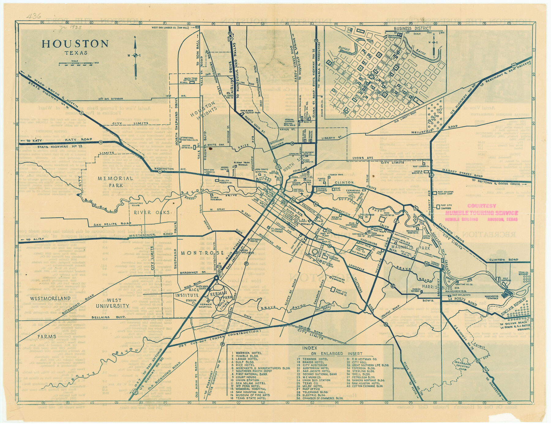
Houston, Texas
-
Map/Doc
79321
-
Collection
Texas State Library and Archives
-
Object Dates
1935 (Creation Date)
-
Counties
Harris
-
Subjects
City
-
Height x Width
17.3 x 22.6 inches
43.9 x 57.4 cm
-
Comments
Prints available courtesy of the Texas State Library and Archives.
More info can be found here: TSLAC Map 00436
Part of: Texas State Library and Archives
General Highway Map, Crosby County, Texas

Print $20.00
General Highway Map, Crosby County, Texas
1940
Size 18.3 x 25.1 inches
Map/Doc 79063
General Highway Map, Carson County, Texas

Print $20.00
General Highway Map, Carson County, Texas
1940
Size 18.5 x 25.1 inches
Map/Doc 79041
General Highway Map, Newton County, Texas

Print $20.00
General Highway Map, Newton County, Texas
1961
Size 19.3 x 25.0 inches
Map/Doc 79612
Preliminary Sketch of Galveston Bay Indicating Proposed Sites for Light Houses

Print $20.00
Preliminary Sketch of Galveston Bay Indicating Proposed Sites for Light Houses
1851
Size 20.7 x 18.0 inches
Map/Doc 76215
General Highway Map, Jeff Davis County, Texas

Print $20.00
General Highway Map, Jeff Davis County, Texas
1940
Size 18.6 x 24.8 inches
Map/Doc 79143
General Highway Map, Upshur County, Texas

Print $20.00
General Highway Map, Upshur County, Texas
1961
Size 18.1 x 24.8 inches
Map/Doc 79692
General Highway Map, Hardeman County, Texas

Print $20.00
General Highway Map, Hardeman County, Texas
1940
Size 25.0 x 18.3 inches
Map/Doc 79113
General Highway Map. Detail of Cities and Towns in Tom Green County, Texas. City Map, San Angelo, Tom Green County, Texas

Print $20.00
General Highway Map. Detail of Cities and Towns in Tom Green County, Texas. City Map, San Angelo, Tom Green County, Texas
1961
Size 18.1 x 24.8 inches
Map/Doc 79679
General Highway Map, Marion County, Texas

Print $20.00
General Highway Map, Marion County, Texas
1961
Size 18.2 x 24.6 inches
Map/Doc 79582
General Highway Map, El Paso County, Texas

Print $20.00
General Highway Map, El Paso County, Texas
1961
Size 18.1 x 24.7 inches
Map/Doc 79457
General Highway Map, Hansford County, Texas

Print $20.00
General Highway Map, Hansford County, Texas
1961
Size 18.0 x 24.5 inches
Map/Doc 79497
General Highway Map, Atascosa County, Texas

Print $20.00
General Highway Map, Atascosa County, Texas
1961
Size 18.3 x 25.0 inches
Map/Doc 79355
You may also like
[Sketch of expeditions, trails in Jones, Taylor, Shackelford, Callahan, Buchanan/Stephens and Eastland Counties]
![65405, [Sketch of expeditions, trails in Jones, Taylor, Shackelford, Callahan, Buchanan/Stephens and Eastland Counties], General Map Collection](https://historictexasmaps.com/wmedia_w700/maps/65405.tif.jpg)
Print $4.00
- Digital $50.00
[Sketch of expeditions, trails in Jones, Taylor, Shackelford, Callahan, Buchanan/Stephens and Eastland Counties]
1873
Size 10.8 x 18.3 inches
Map/Doc 65405
Wise County Sketch File 16 and 17

Print $4.00
- Digital $50.00
Wise County Sketch File 16 and 17
1856
Size 13.1 x 8.3 inches
Map/Doc 40551
Map of the State of Texas

Print $40.00
- Digital $50.00
Map of the State of Texas
1879
Size 102.3 x 57.5 inches
Map/Doc 93385
[Texas Boundary Line]
![92069, [Texas Boundary Line], Twichell Survey Records](https://historictexasmaps.com/wmedia_w700/maps/92069-1.tif.jpg)
Print $20.00
- Digital $50.00
[Texas Boundary Line]
Size 31.8 x 18.1 inches
Map/Doc 92069
Bird's Eye View of Cuero, De Witt County, Texas

Print $20.00
Bird's Eye View of Cuero, De Witt County, Texas
1881
Size 18.4 x 25.5 inches
Map/Doc 89079
McLennan County Sketch File 18

Print $8.00
- Digital $50.00
McLennan County Sketch File 18
1880
Size 12.8 x 8.3 inches
Map/Doc 31280
Wheeler County Working Sketch 8

Print $40.00
- Digital $50.00
Wheeler County Working Sketch 8
1972
Size 59.4 x 42.0 inches
Map/Doc 72497
Clason's Oil Map of Texas and Oklahoma showing the location and approximate area of the oil and gas fields

Print $20.00
- Digital $50.00
Clason's Oil Map of Texas and Oklahoma showing the location and approximate area of the oil and gas fields
1919
Size 22.4 x 24.5 inches
Map/Doc 97158
Montague County Rolled Sketch 1

Print $20.00
- Digital $50.00
Montague County Rolled Sketch 1
Size 31.7 x 26.9 inches
Map/Doc 6786
Hood County Sketch File 25

Print $12.00
- Digital $50.00
Hood County Sketch File 25
1958
Size 11.3 x 8.9 inches
Map/Doc 26623
Freestone County Sketch File 25

Print $18.00
- Digital $50.00
Freestone County Sketch File 25
1952
Size 11.3 x 8.6 inches
Map/Doc 23087
[Neches River Bed, Plat and Calculations]
![77101, [Neches River Bed, Plat and Calculations], General Map Collection](https://historictexasmaps.com/wmedia_w700/maps/77101.tif.jpg)
Print $20.00
- Digital $50.00
[Neches River Bed, Plat and Calculations]
1928
Size 23.2 x 19.8 inches
Map/Doc 77101