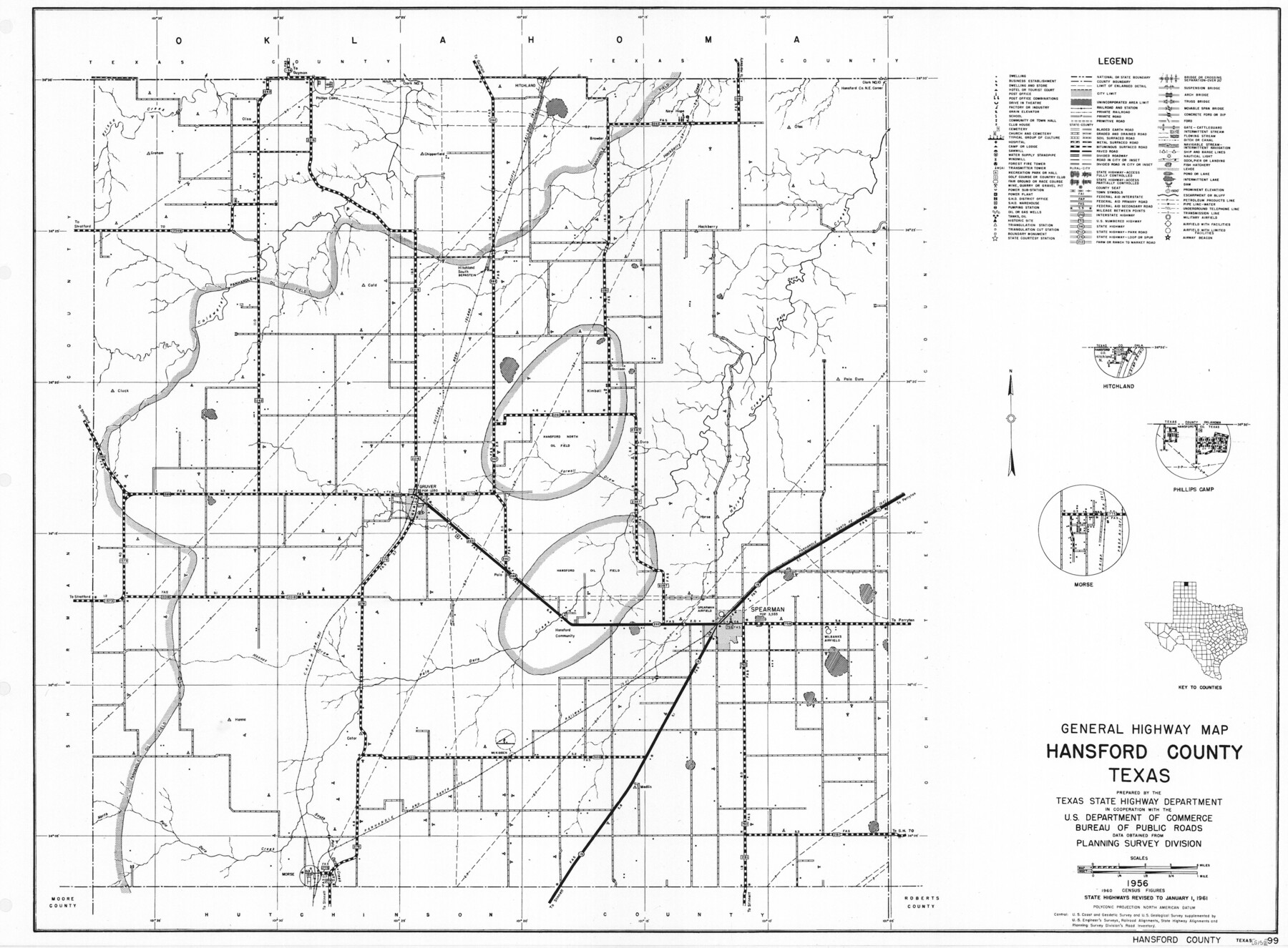
General Highway Map, Hansford County, Texas
-
Map/Doc
79497
-
Collection
Texas State Library and Archives
-
Object Dates
1961 (Creation Date)
-
People and Organizations
Texas State Highway Department (Publisher)
-
Counties
Hansford
-
Subjects
County
-
Height x Width
18.0 x 24.5 inches
45.7 x 62.2 cm
-
Comments
Prints available courtesy of the Texas State Library and Archives.
More info can be found here: TSLAC Map 05158
Part of: Texas State Library and Archives
General Highway Map, Sherman County, Texas

Print $20.00
General Highway Map, Sherman County, Texas
1961
Size 18.2 x 24.8 inches
Map/Doc 79653
General Highway Map, Henderson County, Texas

Print $20.00
General Highway Map, Henderson County, Texas
1939
Size 18.3 x 25.0 inches
Map/Doc 79125
General Highway Map, Scurry County, Texas

Print $20.00
General Highway Map, Scurry County, Texas
1961
Size 18.1 x 24.8 inches
Map/Doc 79650
General Highway Map, Tom Green County, Texas

Print $20.00
General Highway Map, Tom Green County, Texas
1940
Size 24.9 x 18.3 inches
Map/Doc 79259
General Highway Map. Detail of Cities and Towns in McLennan County, Texas [Waco and vicinity]
![79192, General Highway Map. Detail of Cities and Towns in McLennan County, Texas [Waco and vicinity], Texas State Library and Archives](https://historictexasmaps.com/wmedia_w700/maps/79192.tif.jpg)
Print $20.00
General Highway Map. Detail of Cities and Towns in McLennan County, Texas [Waco and vicinity]
1940
Size 18.2 x 24.7 inches
Map/Doc 79192
General Highway Map, Cochran County, Texas

Print $20.00
General Highway Map, Cochran County, Texas
1940
Size 25.2 x 18.5 inches
Map/Doc 79048
Chart of Aransas Harbor

Print $20.00
Chart of Aransas Harbor
1859
Size 14.2 x 17.4 inches
Map/Doc 76292
"Texas New Yorker's" Railroad Map of Texas

Print $20.00
"Texas New Yorker's" Railroad Map of Texas
1874
Size 22.8 x 32.3 inches
Map/Doc 76210
General Highway Map, Reeves County, Texas

Print $20.00
General Highway Map, Reeves County, Texas
1940
Size 24.8 x 18.2 inches
Map/Doc 79227
General Highway Map, San Augustine County, Texas

Print $20.00
General Highway Map, San Augustine County, Texas
1940
Size 24.8 x 18.3 inches
Map/Doc 79235
General Highway Map, Terrell County, Texas

Print $20.00
General Highway Map, Terrell County, Texas
1940
Size 24.9 x 18.4 inches
Map/Doc 79256
Map of the Texas and Pacific Railway and Connections

Print $20.00
Map of the Texas and Pacific Railway and Connections
1897
Size 17.6 x 36.3 inches
Map/Doc 76299
You may also like
Wilbarger County Working Sketch 2b

Print $20.00
- Digital $50.00
Wilbarger County Working Sketch 2b
1922
Size 19.8 x 20.0 inches
Map/Doc 72540
Chambers County Rolled Sketch 24

Print $40.00
- Digital $50.00
Chambers County Rolled Sketch 24
1940
Size 38.2 x 49.9 inches
Map/Doc 8594
Brazoria County Rolled Sketch 34

Print $20.00
- Digital $50.00
Brazoria County Rolled Sketch 34
1944
Size 29.8 x 18.3 inches
Map/Doc 5171
Rio Grande - Fernando Sheet

Print $40.00
- Digital $50.00
Rio Grande - Fernando Sheet
1925
Size 28.8 x 66.7 inches
Map/Doc 65115
"Capture of Cynthia Ann Parker"

Print $20.00
"Capture of Cynthia Ann Parker"
Size 20.0 x 16.0 inches
Map/Doc 94150
General Highway Map. Detail of Cities and Towns in Hays County, Texas [San Marcos and vicinity]
![79514, General Highway Map. Detail of Cities and Towns in Hays County, Texas [San Marcos and vicinity], Texas State Library and Archives](https://historictexasmaps.com/wmedia_w700/maps/79514.tif.jpg)
Print $20.00
General Highway Map. Detail of Cities and Towns in Hays County, Texas [San Marcos and vicinity]
1961
Size 17.9 x 24.5 inches
Map/Doc 79514
Map of Refugio

Print $20.00
- Digital $50.00
Map of Refugio
1851
Size 27.2 x 25.6 inches
Map/Doc 3989
Floyd County Boundary File 1a

Print $40.00
- Digital $50.00
Floyd County Boundary File 1a
Size 9.2 x 37.4 inches
Map/Doc 53460
Val Verde County Sketch File Z0

Print $32.00
- Digital $50.00
Val Verde County Sketch File Z0
1881
Size 28.1 x 10.1 inches
Map/Doc 12550
Topographical Map of the Rio Grande from Roma to the Gulf of Mexico, Index Map, Sheet No. 2

Print $20.00
- Digital $50.00
Topographical Map of the Rio Grande from Roma to the Gulf of Mexico, Index Map, Sheet No. 2
1912
Map/Doc 89524
Hardin County Rolled Sketch TMH

Print $46.00
- Digital $50.00
Hardin County Rolled Sketch TMH
1936
Size 25.7 x 23.9 inches
Map/Doc 6093
Brazoria County Sketch File 55

Print $80.00
- Digital $50.00
Brazoria County Sketch File 55
1899
Size 14.9 x 55.0 inches
Map/Doc 10327