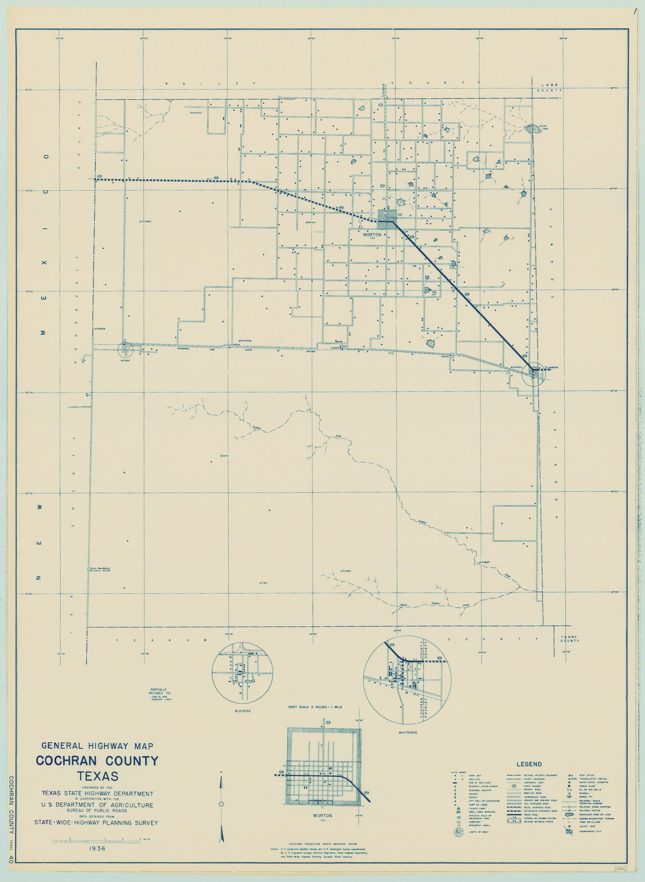
General Highway Map, Cochran County, Texas
-
Map/Doc
79048
-
Collection
Texas State Library and Archives
-
Object Dates
1940 (Creation Date)
-
People and Organizations
Texas State Highway Department (Publisher)
-
Counties
Cochran
-
Subjects
County
-
Height x Width
25.2 x 18.5 inches
64.0 x 47.0 cm
-
Comments
Prints available courtesy of the Texas State Library and Archives.
More info can be found here: TSLAC Map 04821
Part of: Texas State Library and Archives
Carte Reduite des Costes de la Louisiane et de la Floride

Print $20.00
Carte Reduite des Costes de la Louisiane et de la Floride
1764
Size 23.3 x 35.1 inches
Map/Doc 79295
Correct Map of the Railway and Steamship Lines operated by the Southern Pacific Company

Print $20.00
Correct Map of the Railway and Steamship Lines operated by the Southern Pacific Company
1894
Size 17.0 x 40.1 inches
Map/Doc 79333
Description of Best Route from San Antonio to Laredo, Texas

Print $20.00
Description of Best Route from San Antonio to Laredo, Texas
1865
Size 28.6 x 13.7 inches
Map/Doc 79302
Coast Chart no. 109, Aransas Pass, Aransas and Copano Bays, Texas

Print $20.00
Coast Chart no. 109, Aransas Pass, Aransas and Copano Bays, Texas
1884
Size 44.7 x 36.7 inches
Map/Doc 76227
General Highway Map, Jones County, Texas

Print $20.00
General Highway Map, Jones County, Texas
1940
Size 18.5 x 24.8 inches
Map/Doc 79150
General Highway Map, Reagan County, Texas

Print $20.00
General Highway Map, Reagan County, Texas
1940
Size 25.0 x 18.2 inches
Map/Doc 79225
Genl. Austins Map of Texas With Parts of the Adjoining States

Print $20.00
Genl. Austins Map of Texas With Parts of the Adjoining States
1840
Size 30.1 x 24.5 inches
Map/Doc 79293
General Highway Map, Mason County, Texas

Print $20.00
General Highway Map, Mason County, Texas
1961
Size 18.3 x 24.8 inches
Map/Doc 79584

General Highway Map, Brewster County, Texas

Print $20.00
General Highway Map, Brewster County, Texas
1961
Size 18.3 x 24.9 inches
Map/Doc 79386
General Highway Map, Sterling County, Texas

Print $20.00
General Highway Map, Sterling County, Texas
1961
Size 24.8 x 18.1 inches
Map/Doc 79661
Map of the River Sabine from its Mouth on the Gulf of Mexico in the Sea to Logan's Ferry in Latitude 31° 58' 25" North

Print $20.00
Map of the River Sabine from its Mouth on the Gulf of Mexico in the Sea to Logan's Ferry in Latitude 31° 58' 25" North
1840
Size 35.5 x 9.1 inches
Map/Doc 79294
You may also like
Aransas County Working Sketch 23

Print $20.00
- Digital $50.00
Aransas County Working Sketch 23
1970
Size 34.6 x 40.1 inches
Map/Doc 67190
Bandera County Rolled Sketch 11

Print $20.00
- Digital $50.00
Bandera County Rolled Sketch 11
Size 30.8 x 41.1 inches
Map/Doc 77503
McLennan County Sketch File 44

Print $4.00
- Digital $50.00
McLennan County Sketch File 44
1874
Size 12.7 x 7.9 inches
Map/Doc 31335
Webb County Sketch File X

Print $32.00
- Digital $50.00
Webb County Sketch File X
1908
Size 11.2 x 9.0 inches
Map/Doc 39701
St. L. S-W. Ry. of Texas Map of Lufkin Branch in Cherokee County Texas

Print $20.00
- Digital $50.00
St. L. S-W. Ry. of Texas Map of Lufkin Branch in Cherokee County Texas
1912
Size 22.0 x 17.8 inches
Map/Doc 64790
Flight Mission No. CUG-2P, Frame 21, Kleberg County

Print $20.00
- Digital $50.00
Flight Mission No. CUG-2P, Frame 21, Kleberg County
1956
Size 18.5 x 22.3 inches
Map/Doc 86185
S. M. S. Throckmorton Ranch, Throckmorton, Haskell, Baylor Cos.

Print $20.00
- Digital $50.00
S. M. S. Throckmorton Ranch, Throckmorton, Haskell, Baylor Cos.
1955
Size 33.8 x 45.1 inches
Map/Doc 2104
Tom Green County Working Sketch 3

Print $20.00
- Digital $50.00
Tom Green County Working Sketch 3
1933
Size 47.5 x 40.2 inches
Map/Doc 69372
Stonewall County Sketch File 27

Print $8.00
- Digital $50.00
Stonewall County Sketch File 27
1955
Size 10.9 x 7.2 inches
Map/Doc 37296
Kendall County Working Sketch 28a

Print $20.00
- Digital $50.00
Kendall County Working Sketch 28a
2006
Size 29.8 x 45.0 inches
Map/Doc 83097
Throckmorton County Sketch File 11

Print $30.00
- Digital $50.00
Throckmorton County Sketch File 11
1884
Size 8.9 x 11.6 inches
Map/Doc 38105
Grayson County Sketch File 11

Print $4.00
- Digital $50.00
Grayson County Sketch File 11
1857
Size 13.0 x 8.0 inches
Map/Doc 24476