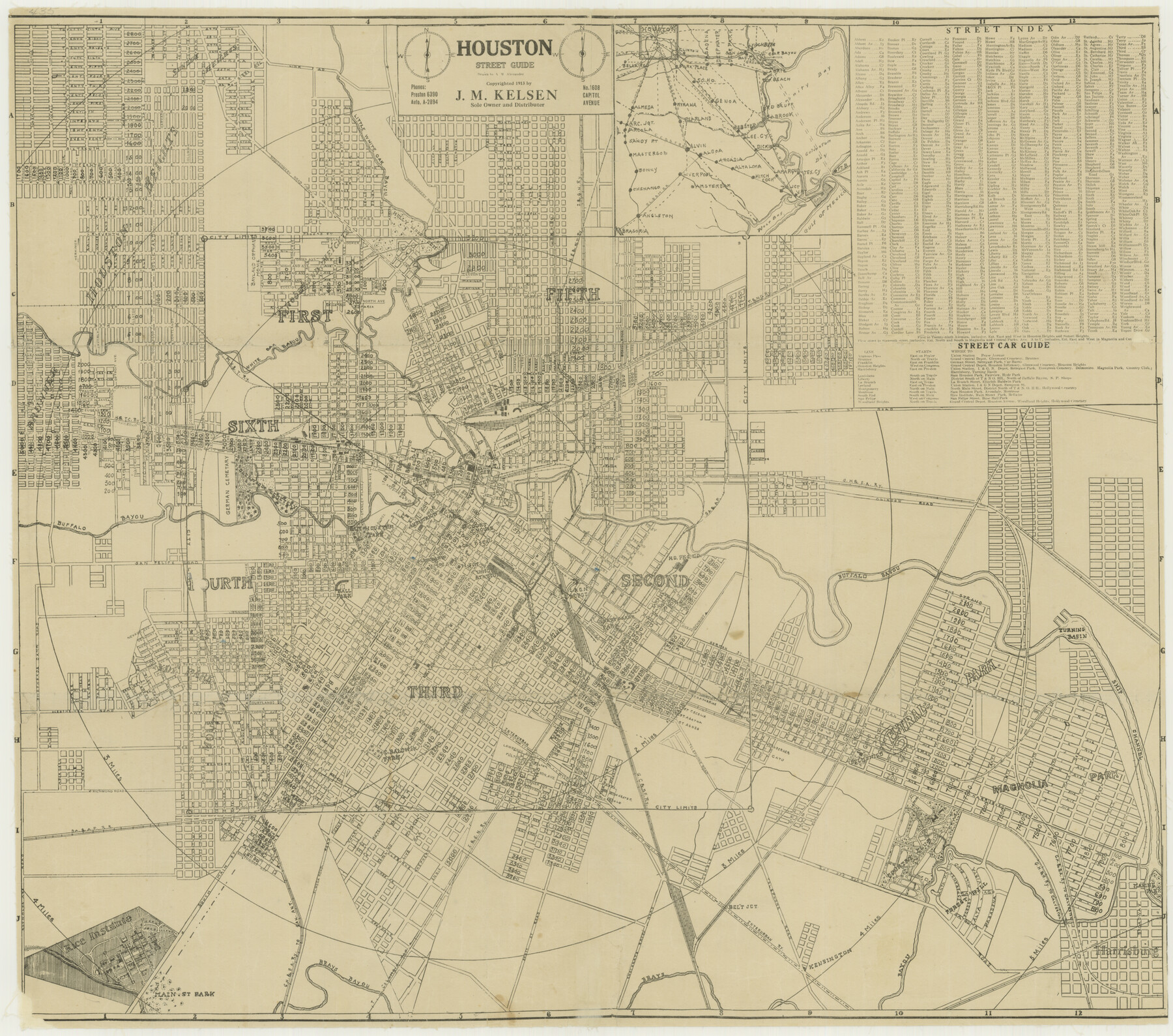
Houston Street Guide
-
Map/Doc
76195
-
Collection
Texas State Library and Archives
-
Object Dates
1913 (Creation Date)
-
People and Organizations
J. M. Kelsen (Publisher)
A.M. Alexander (Draftsman)
-
Counties
Harris
-
Subjects
City
-
Height x Width
26.5 x 30.0 inches
67.3 x 76.2 cm
-
Comments
Prints available courtesy of the Texas State Library and Archives.
More info can be found here: TSLAC Map 00435
Part of: Texas State Library and Archives
General Highway Map, Rains County, Wood County, Texas

Print $20.00
General Highway Map, Rains County, Wood County, Texas
1939
Size 18.2 x 24.8 inches
Map/Doc 79223
General Highway Map, Hardeman County, Texas

Print $20.00
General Highway Map, Hardeman County, Texas
1940
Size 25.0 x 18.3 inches
Map/Doc 79113
Correct Map of the Railway and Steamship Lines operated by the Southern Pacific Company

Print $20.00
Correct Map of the Railway and Steamship Lines operated by the Southern Pacific Company
1894
Size 17.1 x 40.1 inches
Map/Doc 79322
General Highway Map, Reeves County, Texas

Print $20.00
General Highway Map, Reeves County, Texas
1940
Size 24.8 x 18.2 inches
Map/Doc 79227
General Highway Map. Detail of Cities and Towns in Wharton County, Texas

Print $20.00
General Highway Map. Detail of Cities and Towns in Wharton County, Texas
1961
Size 18.3 x 24.8 inches
Map/Doc 79707
General Highway Map, Wilson County, Texas

Print $20.00
General Highway Map, Wilson County, Texas
1940
Size 18.2 x 24.8 inches
Map/Doc 79282
General Highway Map, Waller County, Texas

Print $20.00
General Highway Map, Waller County, Texas
1939
Size 25.1 x 18.5 inches
Map/Doc 79270
General Highway Map, Upshur County, Gregg County, Texas

Print $20.00
General Highway Map, Upshur County, Gregg County, Texas
1939
Size 24.9 x 18.6 inches
Map/Doc 79105
General Highway Map, Cottle County, Texas

Print $20.00
General Highway Map, Cottle County, Texas
1940
Size 18.3 x 25.2 inches
Map/Doc 79060
General Highway Map, Jim Hogg County, Texas

Print $20.00
General Highway Map, Jim Hogg County, Texas
1940
Size 24.8 x 18.5 inches
Map/Doc 79146
General Highway Map, Calhoun County, Texas

Print $20.00
General Highway Map, Calhoun County, Texas
1961
Size 18.3 x 24.4 inches
Map/Doc 79395
General Highway Map, La Salle County, Texas

Print $20.00
General Highway Map, La Salle County, Texas
1961
Size 18.2 x 24.8 inches
Map/Doc 79565
You may also like
Concho County Working Sketch 3

Print $20.00
- Digital $50.00
Concho County Working Sketch 3
1918
Size 24.0 x 22.2 inches
Map/Doc 68185
Texas Railroad Map

Print $20.00
- Digital $50.00
Texas Railroad Map
1981
Size 34.8 x 35.6 inches
Map/Doc 2101
Delta County Working Sketch 3

Print $20.00
- Digital $50.00
Delta County Working Sketch 3
1963
Size 24.9 x 24.4 inches
Map/Doc 68640
Hale County Boundary File 10

Print $62.00
- Digital $50.00
Hale County Boundary File 10
Size 37.9 x 9.4 inches
Map/Doc 54145

Borden County

Print $20.00
- Digital $50.00
Borden County
1922
Size 36.8 x 41.7 inches
Map/Doc 92457
Eastland County Working Sketch 41

Print $20.00
- Digital $50.00
Eastland County Working Sketch 41
1975
Size 37.3 x 34.7 inches
Map/Doc 68822
Lipscomb County Boundary File 14b

Print $60.00
- Digital $50.00
Lipscomb County Boundary File 14b
Size 7.3 x 8.7 inches
Map/Doc 56370
Lynn County Boundary File 3

Print $6.00
- Digital $50.00
Lynn County Boundary File 3
Size 6.3 x 8.8 inches
Map/Doc 56623
Travis County Appraisal District Plat Map 2_0805

Print $20.00
- Digital $50.00
Travis County Appraisal District Plat Map 2_0805
Size 21.4 x 26.4 inches
Map/Doc 94231
Burleson County Working Sketch 28

Print $20.00
- Digital $50.00
Burleson County Working Sketch 28
1981
Size 17.8 x 17.0 inches
Map/Doc 67747
Hardin County Sketch File 44

Print $6.00
- Digital $50.00
Hardin County Sketch File 44
Size 6.7 x 7.4 inches
Map/Doc 25192