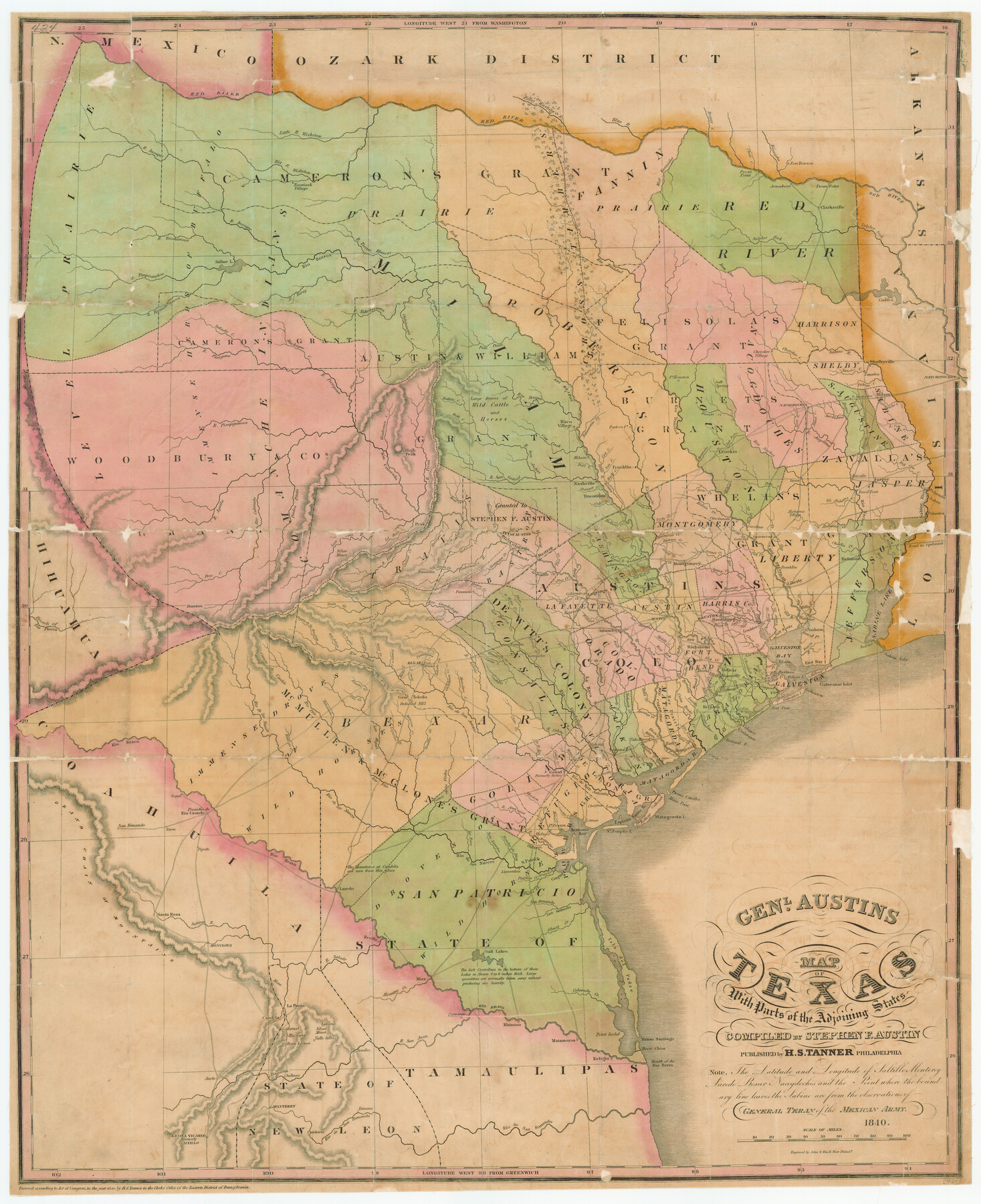
Genl. Austins Map of Texas With Parts of the Adjoining States
-
Map/Doc
79293
-
Collection
Texas State Library and Archives
-
Object Dates
1840 (Creation Date)
-
People and Organizations
H.S. Tanner (Publisher)
John & Wm. W. Warr (Printer)
Stephen F. Austin (Compiler)
-
Subjects
Republic of Texas
-
Height x Width
30.1 x 24.5 inches
76.5 x 62.2 cm
-
Medium
paper, etching/engraving/lithograph
-
Comments
Prints available courtesy of the Texas State Library and Archives.
More info can be found here: TSLAC Map 00424
Part of: Texas State Library and Archives
General Highway Map. Detail of Cities and Towns in Dallas County, Texas [Dallas and vicinity]
![79432, General Highway Map. Detail of Cities and Towns in Dallas County, Texas [Dallas and vicinity], Texas State Library and Archives](https://historictexasmaps.com/wmedia_w700/maps/79432.tif.jpg)
Print $20.00
General Highway Map. Detail of Cities and Towns in Dallas County, Texas [Dallas and vicinity]
1961
Size 18.1 x 24.7 inches
Map/Doc 79432
General Highway Map, Bandera County, Texas

Print $20.00
General Highway Map, Bandera County, Texas
1961
Size 18.3 x 25.0 inches
Map/Doc 79360
Preliminary Chart of the Entrance to Matagorda Bay, Texas

Print $20.00
Preliminary Chart of the Entrance to Matagorda Bay, Texas
1857
Size 20.2 x 32.9 inches
Map/Doc 76247
General Highway Map, Kendall County, Texas

Print $20.00
General Highway Map, Kendall County, Texas
1961
Size 18.3 x 24.6 inches
Map/Doc 79549
General Highway Map, Milam County, Texas

Print $20.00
General Highway Map, Milam County, Texas
1961
Size 18.1 x 24.6 inches
Map/Doc 79597
General Highway Map, Kerr County, Texas

Print $20.00
General Highway Map, Kerr County, Texas
1940
Size 24.8 x 18.2 inches
Map/Doc 79157
General Highway Map, Crockett County, Texas

Print $20.00
General Highway Map, Crockett County, Texas
1940
Size 18.3 x 25.1 inches
Map/Doc 79062
General Highway Map, Wharton County, Texas

Print $20.00
General Highway Map, Wharton County, Texas
1961
Size 18.3 x 24.7 inches
Map/Doc 79706
General Highway Map, Hutchinson County, Texas

Print $20.00
General Highway Map, Hutchinson County, Texas
1940
Size 18.3 x 24.8 inches
Map/Doc 79137
General Highway Map, Cherokee County, Texas

Print $20.00
General Highway Map, Cherokee County, Texas
1961
Size 18.2 x 24.7 inches
Map/Doc 79406

General Highway Map, Jasper County, Newton County, Texas

Print $20.00
General Highway Map, Jasper County, Newton County, Texas
1940
Size 18.6 x 25.0 inches
Map/Doc 79141
You may also like
Armstrong County Sketch File D

Print $40.00
- Digital $50.00
Armstrong County Sketch File D
Size 16.1 x 21.0 inches
Map/Doc 10857
San Jacinto County Working Sketch 23

Print $40.00
- Digital $50.00
San Jacinto County Working Sketch 23
1940
Size 31.5 x 53.8 inches
Map/Doc 63736
Galveston County NRC Article 33.136 Sketch 24

Print $22.00
- Digital $50.00
Galveston County NRC Article 33.136 Sketch 24
2003
Size 24.8 x 36.3 inches
Map/Doc 87919
Garden City Townsite, Section 5, Range 4 South, Block 33

Print $3.00
- Digital $50.00
Garden City Townsite, Section 5, Range 4 South, Block 33
1886
Size 9.4 x 14.5 inches
Map/Doc 90764
[Area along West County Line]
![90833, [Area along West County Line], Twichell Survey Records](https://historictexasmaps.com/wmedia_w700/maps/90833-2.tif.jpg)
Print $2.00
- Digital $50.00
[Area along West County Line]
Size 7.0 x 9.6 inches
Map/Doc 90833
Motley County Sketch File C (N)

Print $48.00
- Digital $50.00
Motley County Sketch File C (N)
Size 7.7 x 18.4 inches
Map/Doc 31978
Flight Mission No. DCL-6C, Frame 46, Kenedy County

Print $20.00
- Digital $50.00
Flight Mission No. DCL-6C, Frame 46, Kenedy County
1943
Size 18.6 x 22.3 inches
Map/Doc 85888
Map Showing Ten Divisions of the C. C. Slaughter Cattle Company's Ranch in Hockley and Cochran Counties, Texas

Print $3.00
- Digital $50.00
Map Showing Ten Divisions of the C. C. Slaughter Cattle Company's Ranch in Hockley and Cochran Counties, Texas
Size 13.2 x 10.7 inches
Map/Doc 91126
Marion County Working Sketch 9

Print $20.00
- Digital $50.00
Marion County Working Sketch 9
1940
Size 23.5 x 25.5 inches
Map/Doc 70784
Hudspeth County Sketch File 19

Print $4.00
- Digital $50.00
Hudspeth County Sketch File 19
1901
Size 11.3 x 8.8 inches
Map/Doc 26962
Spanish North America

Print $20.00
- Digital $50.00
Spanish North America
1814
Size 21.9 x 29.8 inches
Map/Doc 89224
Fisher County Working Sketch 5

Print $20.00
- Digital $50.00
Fisher County Working Sketch 5
1926
Size 23.0 x 25.6 inches
Map/Doc 69139