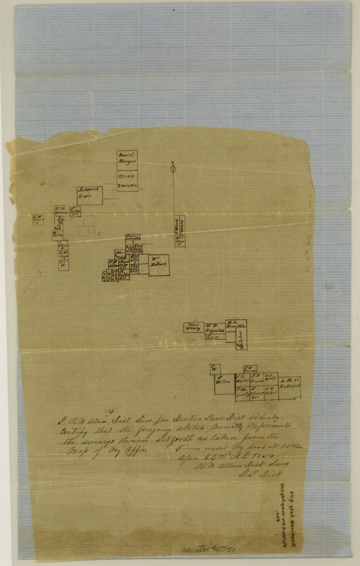
Wise County Sketch File 16 and 17
[Sketch of surveys in Wise and Parker Counties]
-
Map/Doc
40551
-
Collection
General Map Collection
-
Object Dates
4/23/1856 (Creation Date)
-
People and Organizations
R.W. Allen (Surveyor/Engineer)
-
Counties
Wise Parker
-
Subjects
Surveying Sketch File
-
Height x Width
13.1 x 8.3 inches
33.3 x 21.1 cm
-
Medium
paper, manuscript
Part of: General Map Collection
Map of France, Spain, Portugal and Italy engraved to illustrate Mitchell's school and family geography (Inset: Greece and the Ionian Islands)

Print $20.00
- Digital $50.00
Map of France, Spain, Portugal and Italy engraved to illustrate Mitchell's school and family geography (Inset: Greece and the Ionian Islands)
1846
Size 9.5 x 11.8 inches
Map/Doc 93505
Panola County Working Sketch 41

Print $20.00
- Digital $50.00
Panola County Working Sketch 41
1995
Map/Doc 71450
Montgomery County Rolled Sketch 36

Print $20.00
- Digital $50.00
Montgomery County Rolled Sketch 36
1956
Size 25.8 x 23.6 inches
Map/Doc 6812
Polk County Sketch File 19

Print $4.00
- Digital $50.00
Polk County Sketch File 19
1863
Size 8.2 x 12.7 inches
Map/Doc 34165
Robertson County Sketch File 12

Print $18.00
Robertson County Sketch File 12
1987
Size 11.4 x 8.8 inches
Map/Doc 35404

Briscoe County Sketch File 13

Print $168.00
- Digital $50.00
Briscoe County Sketch File 13
1982
Size 11.2 x 8.7 inches
Map/Doc 16428
Borden County Rolled Sketch 7

Print $20.00
- Digital $50.00
Borden County Rolled Sketch 7
Size 16.9 x 18.5 inches
Map/Doc 5157
Flight Mission No. DAH-17M, Frame 61, Orange County

Print $20.00
- Digital $50.00
Flight Mission No. DAH-17M, Frame 61, Orange County
1953
Size 18.6 x 22.5 inches
Map/Doc 86895
G. C. & S. F. Ry., San Saba Branch, Texas, Right of Way Map, Hall to Brady

Print $20.00
- Digital $50.00
G. C. & S. F. Ry., San Saba Branch, Texas, Right of Way Map, Hall to Brady
1916
Size 36.9 x 34.0 inches
Map/Doc 61419
Plat of Jasper, Sabine, San Augustine, Shelby, Harrison and South Part of Nacogdoches Counties

Print $2.00
- Digital $50.00
Plat of Jasper, Sabine, San Augustine, Shelby, Harrison and South Part of Nacogdoches Counties
1841
Size 13.7 x 9.2 inches
Map/Doc 3174
Brewster County Rolled Sketch 122

Print $20.00
- Digital $50.00
Brewster County Rolled Sketch 122
1974
Size 31.9 x 24.6 inches
Map/Doc 5298
You may also like
Chambers County Working Sketch 6

Print $20.00
- Digital $50.00
Chambers County Working Sketch 6
1938
Size 14.3 x 19.7 inches
Map/Doc 67989
Flight Mission No. CUG-1P, Frame 43, Kleberg County

Print $20.00
- Digital $50.00
Flight Mission No. CUG-1P, Frame 43, Kleberg County
1956
Size 18.6 x 22.4 inches
Map/Doc 86121
Right-of-Way and Track Map, Texas State Railroad operated by the T. and N.O. R.R. Co.

Print $40.00
- Digital $50.00
Right-of-Way and Track Map, Texas State Railroad operated by the T. and N.O. R.R. Co.
1917
Size 25.2 x 56.1 inches
Map/Doc 64171
Shelby County Working Sketch 10

Print $20.00
- Digital $50.00
Shelby County Working Sketch 10
1945
Size 42.8 x 43.9 inches
Map/Doc 63863
[Southwest corner of county covering Blks. 24 and B9]
![90489, [Southwest corner of county covering Blks. 24 and B9], Twichell Survey Records](https://historictexasmaps.com/wmedia_w700/maps/90489-1.tif.jpg)
Print $20.00
- Digital $50.00
[Southwest corner of county covering Blks. 24 and B9]
1905
Size 16.7 x 13.9 inches
Map/Doc 90489
Flight Mission No. BRA-7M, Frame 28, Jefferson County

Print $20.00
- Digital $50.00
Flight Mission No. BRA-7M, Frame 28, Jefferson County
1953
Size 18.5 x 22.4 inches
Map/Doc 85479
Starr County Sketch File 30A

Print $20.00
- Digital $50.00
Starr County Sketch File 30A
1935
Size 21.2 x 23.6 inches
Map/Doc 12334
Picturesque Glen Ridge, A Beautiful Suburb of Austin

Print $20.00
- Digital $50.00
Picturesque Glen Ridge, A Beautiful Suburb of Austin
1890
Size 28.9 x 40.9 inches
Map/Doc 584
Montgomery County Sketch File 39

Print $4.00
- Digital $50.00
Montgomery County Sketch File 39
1941
Size 14.6 x 8.6 inches
Map/Doc 31923
Tarrant County Rolled Sketch 4

Print $20.00
- Digital $50.00
Tarrant County Rolled Sketch 4
1982
Size 27.2 x 19.2 inches
Map/Doc 7912
Real County Rolled Sketch 18

Print $20.00
- Digital $50.00
Real County Rolled Sketch 18
Size 22.0 x 28.0 inches
Map/Doc 7464
Castro County Working Sketch Graphic Index

Print $20.00
- Digital $50.00
Castro County Working Sketch Graphic Index
1932
Size 43.1 x 38.2 inches
Map/Doc 76490