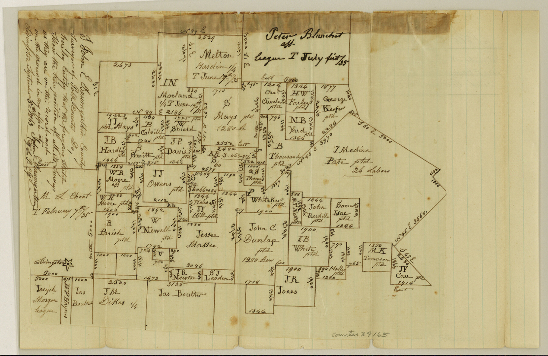
Polk County Sketch File 19
[Sketch including and northeast of Livingston]
-
Map/Doc
34165
-
Collection
General Map Collection
-
Object Dates
9/5/1863 (Creation Date)
10/14/1863 (File Date)
-
People and Organizations
John E. Baumgarten (Surveyor/Engineer)
-
Counties
Polk
-
Subjects
Surveying Sketch File
-
Height x Width
8.2 x 12.7 inches
20.8 x 32.3 cm
-
Medium
paper, manuscript
-
Features
Livingston
Part of: General Map Collection
Dickens County Rolled Sketch C & C1

Print $35.00
- Digital $50.00
Dickens County Rolled Sketch C & C1
1895
Size 10.6 x 15.5 inches
Map/Doc 44297
Hardin County Rolled Sketch 15

Print $20.00
- Digital $50.00
Hardin County Rolled Sketch 15
1938
Size 30.9 x 23.7 inches
Map/Doc 6084
Mills County Working Sketch 18

Print $20.00
- Digital $50.00
Mills County Working Sketch 18
1963
Size 23.2 x 37.0 inches
Map/Doc 71048
Jefferson County NRC Article 33.136 Location Key Sheet

Print $20.00
- Digital $50.00
Jefferson County NRC Article 33.136 Location Key Sheet
1993
Size 27.0 x 21.8 inches
Map/Doc 77030
Kimble County Working Sketch 53

Print $20.00
- Digital $50.00
Kimble County Working Sketch 53
1953
Size 24.5 x 35.9 inches
Map/Doc 70121
Rains County Working Sketch 11

Print $20.00
- Digital $50.00
Rains County Working Sketch 11
Size 40.1 x 35.1 inches
Map/Doc 71837
Flight Mission No. BRE-1P, Frame 30, Nueces County

Print $20.00
- Digital $50.00
Flight Mission No. BRE-1P, Frame 30, Nueces County
1956
Size 18.4 x 22.3 inches
Map/Doc 86626
Refugio County Sketch File 11

Print $6.00
- Digital $50.00
Refugio County Sketch File 11
Size 8.0 x 8.2 inches
Map/Doc 35260
Tyler County Sketch File 1a

Print $4.00
- Digital $50.00
Tyler County Sketch File 1a
1855
Size 8.2 x 10.3 inches
Map/Doc 38609
Fisher County Boundary File 3a

Print $20.00
- Digital $50.00
Fisher County Boundary File 3a
Size 25.1 x 26.0 inches
Map/Doc 53444
Harris County Sketch File 3

Print $4.00
- Digital $50.00
Harris County Sketch File 3
Size 7.0 x 6.2 inches
Map/Doc 25334
Frio County Sketch File 12

Print $18.00
- Digital $50.00
Frio County Sketch File 12
1938
Size 14.2 x 8.7 inches
Map/Doc 23127
You may also like

Hardin County Working Sketch 39, part 1

Print $20.00
- Digital $50.00
Hardin County Working Sketch 39, part 1
1985
Size 34.4 x 47.1 inches
Map/Doc 63437
Hale County Sketch File B

Print $20.00
- Digital $50.00
Hale County Sketch File B
1897
Size 17.3 x 23.9 inches
Map/Doc 11599
Dimmit County Working Sketch 49

Print $40.00
- Digital $50.00
Dimmit County Working Sketch 49
1980
Size 78.8 x 44.7 inches
Map/Doc 68710
National Map Company's Ohio showing Counties, Townships, Cities, Villages, Post Offices, Steam and Electric Railways, With Stations and Distances Between Stations

Print $20.00
- Digital $50.00
National Map Company's Ohio showing Counties, Townships, Cities, Villages, Post Offices, Steam and Electric Railways, With Stations and Distances Between Stations
1920
Size 38.7 x 32.3 inches
Map/Doc 97109
Dimmit County Sketch File 36

Print $6.00
- Digital $50.00
Dimmit County Sketch File 36
1894
Size 4.3 x 13.3 inches
Map/Doc 21158
International Railroad Map & Profile of the Second Fifty Miles East of Brazos River

Print $40.00
- Digital $50.00
International Railroad Map & Profile of the Second Fifty Miles East of Brazos River
1877
Size 19.0 x 52.0 inches
Map/Doc 64466
Flight Mission No. DCL-7C, Frame 18, Kenedy County

Print $20.00
- Digital $50.00
Flight Mission No. DCL-7C, Frame 18, Kenedy County
1943
Size 15.4 x 15.2 inches
Map/Doc 86010
Flight Mission No. CRC-1R, Frame 154, Chambers County

Print $20.00
- Digital $50.00
Flight Mission No. CRC-1R, Frame 154, Chambers County
1956
Size 18.9 x 22.5 inches
Map/Doc 84716
Brazoria County Rolled Sketch 39
Print $20.00
- Digital $50.00
Brazoria County Rolled Sketch 39
1949
Size 22.8 x 34.8 inches
Map/Doc 5174
Brewster County Rolled Sketch 28

Print $20.00
- Digital $50.00
Brewster County Rolled Sketch 28
1910
Size 25.6 x 29.4 inches
Map/Doc 5215
Midland County Sketch File 2

Print $20.00
- Digital $50.00
Midland County Sketch File 2
1886
Size 16.3 x 17.6 inches
Map/Doc 12080