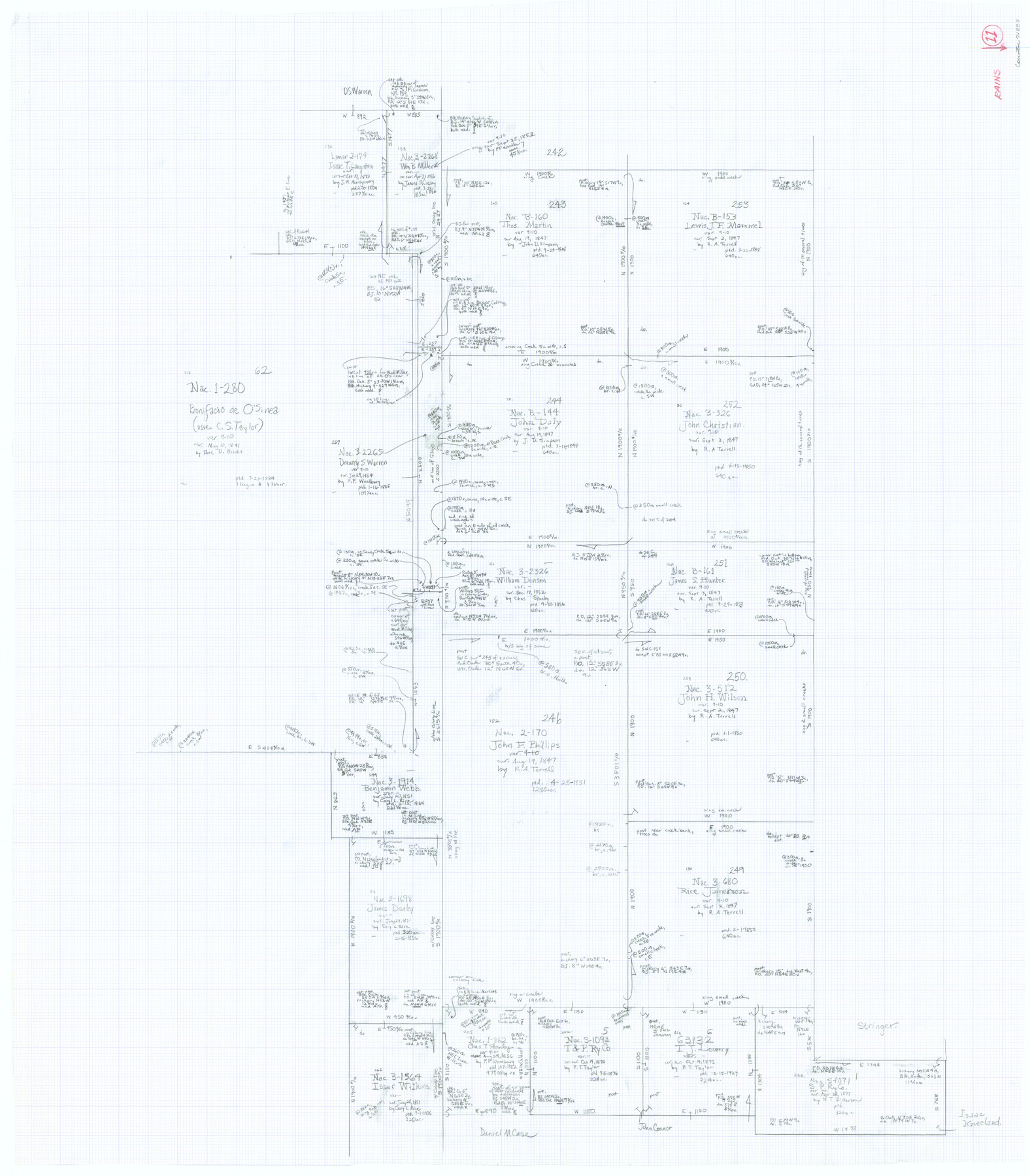
Rains County Working Sketch 11
-
Map/Doc
71837
-
Collection
General Map Collection
-
Counties
Rains
-
Subjects
Surveying Working Sketch
-
Height x Width
40.1 x 35.1 inches
101.9 x 89.2 cm
Part of: General Map Collection
Haskell County Sketch File 12

Print $20.00
- Digital $50.00
Haskell County Sketch File 12
1881
Size 18.8 x 23.6 inches
Map/Doc 11741
Pottsboro Quadrangle

Print $20.00
- Digital $50.00
Pottsboro Quadrangle
1999
Size 35.4 x 23.4 inches
Map/Doc 97363

Aransas County Sketch File 15a

Print $14.00
- Digital $50.00
Aransas County Sketch File 15a
Size 11.0 x 8.4 inches
Map/Doc 13136
Topographical Map of the Rio Grande, Sheet No. 10

Print $20.00
- Digital $50.00
Topographical Map of the Rio Grande, Sheet No. 10
1912
Map/Doc 89534
Atascosa County Boundary File 2

Print $52.00
- Digital $50.00
Atascosa County Boundary File 2
Size 8.9 x 36.2 inches
Map/Doc 50160
Bandera County Working Sketch 26

Print $20.00
- Digital $50.00
Bandera County Working Sketch 26
1951
Size 32.3 x 28.4 inches
Map/Doc 67622
Flight Mission No. BQR-20K, Frame 11, Brazoria County

Print $20.00
- Digital $50.00
Flight Mission No. BQR-20K, Frame 11, Brazoria County
1952
Size 18.7 x 22.3 inches
Map/Doc 84113
Flight Mission No. CLL-1N, Frame 195, Willacy County

Print $20.00
- Digital $50.00
Flight Mission No. CLL-1N, Frame 195, Willacy County
1954
Size 18.5 x 22.3 inches
Map/Doc 87065
Childress County Working Sketch 7

Print $20.00
- Digital $50.00
Childress County Working Sketch 7
1960
Size 20.7 x 14.8 inches
Map/Doc 68023
Birds-eye view of the camp of the army of occupation commanded by Genl. Taylor near Corpus Christi, Texas (from the North)

Print $20.00
- Digital $50.00
Birds-eye view of the camp of the army of occupation commanded by Genl. Taylor near Corpus Christi, Texas (from the North)
1847
Size 15.8 x 20.5 inches
Map/Doc 95951
Crockett County Working Sketch 44

Print $20.00
- Digital $50.00
Crockett County Working Sketch 44
1933
Size 34.2 x 17.4 inches
Map/Doc 68377
You may also like
Edwards County Working Sketch Graphic Index - east part - sheet 1

Print $40.00
- Digital $50.00
Edwards County Working Sketch Graphic Index - east part - sheet 1
1975
Size 54.8 x 39.9 inches
Map/Doc 76533
[Drawings of individual counties for Pressler and Langermann's 1879 Map of Texas]
![[Drawings of individual counties for Pressler and Langermann's 1879 Map of Texas]](https://historictexasmaps.com/wmedia_w700/maps/4864.tif.jpg)
Print $20.00
- Digital $50.00
[Drawings of individual counties for Pressler and Langermann's 1879 Map of Texas]
1878
Size 38.3 x 26.8 inches
Map/Doc 4864
General Highway Map, Taylor County, Texas

Print $20.00
General Highway Map, Taylor County, Texas
1961
Size 18.2 x 24.8 inches
Map/Doc 79672
Flight Mission No. DCL-7C, Frame 12, Kenedy County

Print $20.00
- Digital $50.00
Flight Mission No. DCL-7C, Frame 12, Kenedy County
1943
Size 15.4 x 15.3 inches
Map/Doc 86004
Flight Mission No. CRC-2R, Frame 184, Chambers County

Print $20.00
- Digital $50.00
Flight Mission No. CRC-2R, Frame 184, Chambers County
1956
Size 18.6 x 22.2 inches
Map/Doc 84762
Mitchell Estate Subdivision

Print $20.00
- Digital $50.00
Mitchell Estate Subdivision
1953
Size 9.3 x 19.8 inches
Map/Doc 92505
El Paso County Boundary File 17

Print $8.00
- Digital $50.00
El Paso County Boundary File 17
Size 13.4 x 8.4 inches
Map/Doc 53192
Travis County Sketch File 27

Print $8.00
- Digital $50.00
Travis County Sketch File 27
1872
Size 12.9 x 8.3 inches
Map/Doc 38338
Childress County Sketch File 18a

Print $4.00
- Digital $50.00
Childress County Sketch File 18a
1935
Size 11.3 x 7.1 inches
Map/Doc 18364
Jasper County Working Sketch 27

Print $20.00
- Digital $50.00
Jasper County Working Sketch 27
1954
Size 38.3 x 19.4 inches
Map/Doc 66489
Coast Chart No. 210 Aransas Pass and Corpus Christi Bay with the coast to latitude 27° 12' Texas

Print $20.00
- Digital $50.00
Coast Chart No. 210 Aransas Pass and Corpus Christi Bay with the coast to latitude 27° 12' Texas
1887
Size 27.6 x 18.2 inches
Map/Doc 72785
General Highway Map. Detail of Cities and Towns in Dallas County, Texas [Dallas and vicinity]
![79067, General Highway Map. Detail of Cities and Towns in Dallas County, Texas [Dallas and vicinity], Texas State Library and Archives](https://historictexasmaps.com/wmedia_w700/maps/79067.tif.jpg)
Print $20.00
General Highway Map. Detail of Cities and Towns in Dallas County, Texas [Dallas and vicinity]
1936
Size 18.3 x 25.1 inches
Map/Doc 79067