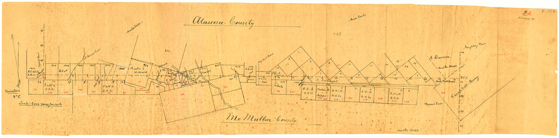
Atascosa County Boundary File 2
Atascosa County South Bdy. Line & North bdy. Line of McMullen
-
Map/Doc
50160
-
Collection
General Map Collection
-
Counties
Atascosa
-
Subjects
County Boundaries
-
Height x Width
8.9 x 36.2 inches
22.6 x 91.9 cm
Part of: General Map Collection
[Surveys near Keechi Creek and the Trinity River]
![47, [Surveys near Keechi Creek and the Trinity River], General Map Collection](https://historictexasmaps.com/wmedia_w700/maps/47.tif.jpg)
Print $2.00
- Digital $50.00
[Surveys near Keechi Creek and the Trinity River]
1841
Size 8.6 x 8.2 inches
Map/Doc 47
Kinney County Sketch File 27

Print $42.00
- Digital $50.00
Kinney County Sketch File 27
1929
Size 32.4 x 13.2 inches
Map/Doc 11946
Edwards County Sketch File ABC

Print $12.00
- Digital $50.00
Edwards County Sketch File ABC
1913
Size 14.5 x 9.1 inches
Map/Doc 21662
Lavaca County Rolled Sketch 7

Print $20.00
- Digital $50.00
Lavaca County Rolled Sketch 7
Size 37.4 x 32.7 inches
Map/Doc 10291
Terrell County Working Sketch 84a

Print $20.00
- Digital $50.00
Terrell County Working Sketch 84a
1992
Size 34.5 x 37.0 inches
Map/Doc 69605
Location of the Southern Kansas Railway of Texas through Hemphill County, Texas

Print $40.00
- Digital $50.00
Location of the Southern Kansas Railway of Texas through Hemphill County, Texas
1887
Size 20.2 x 91.8 inches
Map/Doc 64000
Flight Mission No. BRE-2P, Frame 135, Nueces County

Print $20.00
- Digital $50.00
Flight Mission No. BRE-2P, Frame 135, Nueces County
1956
Size 18.5 x 22.7 inches
Map/Doc 86808
Hutchinson County Sketch File 5

Print $60.00
- Digital $50.00
Hutchinson County Sketch File 5
Size 15.1 x 62.7 inches
Map/Doc 10498
Nueces County Rolled Sketch 110A

Print $20.00
- Digital $50.00
Nueces County Rolled Sketch 110A
1990
Size 24.3 x 37.5 inches
Map/Doc 7118
Louisiana and Texas Intracoastal Waterway

Print $20.00
- Digital $50.00
Louisiana and Texas Intracoastal Waterway
1929
Size 13.7 x 19.0 inches
Map/Doc 83344
Liberty County Sketch File 2

Print $2.00
- Digital $50.00
Liberty County Sketch File 2
Size 7.7 x 3.3 inches
Map/Doc 29883
Harris County Sketch File 20

Print $6.00
- Digital $50.00
Harris County Sketch File 20
1862
Size 8.6 x 7.9 inches
Map/Doc 25368
You may also like
Flight Mission No. BRA-3M, Frame 198, Jefferson County

Print $20.00
- Digital $50.00
Flight Mission No. BRA-3M, Frame 198, Jefferson County
1953
Size 18.7 x 22.4 inches
Map/Doc 85413
Travis County Working Sketch 6

Print $20.00
- Digital $50.00
Travis County Working Sketch 6
1913
Size 28.9 x 20.6 inches
Map/Doc 69390
[Surveys 111-114, north of Morris County School Land]
![90362, [Surveys 111-114, north of Morris County School Land], Twichell Survey Records](https://historictexasmaps.com/wmedia_w700/maps/90362-1.tif.jpg)
Print $20.00
- Digital $50.00
[Surveys 111-114, north of Morris County School Land]
Size 23.7 x 8.2 inches
Map/Doc 90362
Palo Pinto County Working Sketch 5

Print $40.00
- Digital $50.00
Palo Pinto County Working Sketch 5
1920
Map/Doc 71388
Jackson County Sketch File 16

Print $10.00
- Digital $50.00
Jackson County Sketch File 16
1913
Size 14.3 x 8.7 inches
Map/Doc 27668
Galveston County NRC Article 33.136 Sketch 3

Print $20.00
- Digital $50.00
Galveston County NRC Article 33.136 Sketch 3
2001
Size 22.4 x 34.0 inches
Map/Doc 61567
[Lgs. 180-183, 196-198, 105-112, 678-680, 699-701, 141-143]
![90153, [Lgs. 180-183, 196-198, 105-112, 678-680, 699-701, 141-143], Twichell Survey Records](https://historictexasmaps.com/wmedia_w700/maps/90153-1.tif.jpg)
Print $3.00
- Digital $50.00
[Lgs. 180-183, 196-198, 105-112, 678-680, 699-701, 141-143]
1913
Size 14.9 x 9.9 inches
Map/Doc 90153
Fannin County Working Sketch 8

Print $20.00
- Digital $50.00
Fannin County Working Sketch 8
1955
Size 27.2 x 16.0 inches
Map/Doc 69162
Kenedy County Aerial Photograph Index Sheet 1

Print $20.00
- Digital $50.00
Kenedy County Aerial Photograph Index Sheet 1
1943
Size 23.3 x 19.5 inches
Map/Doc 83713
Brazos River Conservation and Reclamation District Official Boundary Line Survey

Print $20.00
- Digital $50.00
Brazos River Conservation and Reclamation District Official Boundary Line Survey
Size 37.1 x 24.7 inches
Map/Doc 90127
Chambers County Sketch File 22

Print $8.00
- Digital $50.00
Chambers County Sketch File 22
Size 12.2 x 7.6 inches
Map/Doc 17594
Harris County Sketch File H

Print $4.00
- Digital $50.00
Harris County Sketch File H
1860
Size 8.2 x 5.5 inches
Map/Doc 25321