Edwards County Sketch File ABC
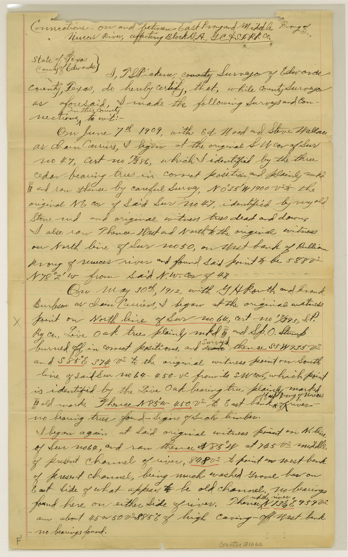
[Connections on and between East Prong and Middle Prong of Nueces River, affecting Block DA, G. C. & S. F. RR. Co.]
-
Map/Doc
21662
-
Collection
General Map Collection
-
Object Dates
1913/1/13 (Creation Date)
1913/1/28 (File Date)
1909/6/7 (Survey Date)
1912/5/30 (Survey Date)
1912/12/2 (Survey Date)
1912/7/25 (Survey Date)
1912/11/9 (Survey Date)
1912/11/20 (Survey Date)
1912/11/23 (Survey Date)
-
People and Organizations
Tom Nowlin (Chainman)
T.S. Pickens (Surveyor/Engineer)
Ed Wood (Chainman)
Steve Wallace (Chainman)
G.H. Routh (Chainman)
Frank Burleson (Chainman)
Will Vernon (Chainman)
Russel Vernon (Chainman)
G.M. Williams (Surveyor/Engineer)
A.P. Allison (Chainman)
Wren Caruthers (Chainman)
R.J. Verner (Chainman)
T.J. Renvis (Chainman)
T.F. Hamrick (Chainman)
A. Pallison (Chainman)
John Saunders (Chainman)
Ben Hamrick (Chainman)
-
Counties
Edwards
-
Subjects
Surveying Sketch File
-
Height x Width
14.5 x 9.1 inches
36.8 x 23.1 cm
-
Medium
paper, manuscript
-
Features
East Prong of Nueces River
Middle Prong of Nueces River
Pulliam Prong of Nuces River
Bull Head Creek
Vance
Nueces River
Part of: General Map Collection
McMullen County Rolled Sketch 20

Print $20.00
- Digital $50.00
McMullen County Rolled Sketch 20
Size 27.7 x 21.7 inches
Map/Doc 6736
Starr County Rolled Sketch 46B

Print $20.00
- Digital $50.00
Starr County Rolled Sketch 46B
1986
Size 17.9 x 34.5 inches
Map/Doc 7838
Edwards County

Print $20.00
- Digital $50.00
Edwards County
1893
Size 25.8 x 29.4 inches
Map/Doc 3506
Borden County Sketch File 1

Print $6.00
- Digital $50.00
Borden County Sketch File 1
Size 16.2 x 11.0 inches
Map/Doc 14701
Map of Lampasas County

Print $40.00
- Digital $50.00
Map of Lampasas County
1900
Size 47.1 x 60.2 inches
Map/Doc 62971
Jefferson County Sketch File 51

Print $10.00
- Digital $50.00
Jefferson County Sketch File 51
Size 10.0 x 6.7 inches
Map/Doc 28249
Burnet County Sketch File 42

Print $28.00
- Digital $50.00
Burnet County Sketch File 42
1950
Size 9.9 x 8.8 inches
Map/Doc 16760
Map of Panola County

Print $20.00
- Digital $50.00
Map of Panola County
1897
Size 40.5 x 39.0 inches
Map/Doc 16785
Brewster County Rolled Sketch 60

Print $20.00
- Digital $50.00
Brewster County Rolled Sketch 60
Size 25.0 x 37.5 inches
Map/Doc 8484
Hemphill County Working Sketch 35

Print $20.00
- Digital $50.00
Hemphill County Working Sketch 35
1978
Size 35.9 x 44.8 inches
Map/Doc 66130
Map of Grayson County

Print $20.00
- Digital $50.00
Map of Grayson County
1871
Size 19.5 x 17.8 inches
Map/Doc 1088
Wharton County Working Sketch 6

Print $20.00
- Digital $50.00
Wharton County Working Sketch 6
1990
Size 24.7 x 21.1 inches
Map/Doc 72470
You may also like
Traveller's Map of the State of Texas

Print $20.00
Traveller's Map of the State of Texas
1867
Size 42.5 x 41.1 inches
Map/Doc 76226
[Capitol Leagues 225-238]
![90677, [Capitol Leagues 225-238], Twichell Survey Records](https://historictexasmaps.com/wmedia_w700/maps/90677-1.tif.jpg)
Print $20.00
- Digital $50.00
[Capitol Leagues 225-238]
Size 23.2 x 13.0 inches
Map/Doc 90677
Calhoun County Rolled Sketch 12

Print $40.00
- Digital $50.00
Calhoun County Rolled Sketch 12
1940
Size 37.9 x 54.6 inches
Map/Doc 66845
Hutchinson County

Print $20.00
- Digital $50.00
Hutchinson County
1922
Size 40.7 x 34.8 inches
Map/Doc 77321
Mapa de Texas con partes de los Estados Adyacentes

Mapa de Texas con partes de los Estados Adyacentes
1832
Size 6.8 x 5.7 inches
Map/Doc 94560
Shelby County Working Sketch 4

Print $20.00
- Digital $50.00
Shelby County Working Sketch 4
1941
Size 32.3 x 41.8 inches
Map/Doc 63857
Colorado River, Matagorda Sheet

Print $6.00
- Digital $50.00
Colorado River, Matagorda Sheet
1937
Size 30.9 x 35.8 inches
Map/Doc 65303
Medina County Working Sketch 7

Print $20.00
- Digital $50.00
Medina County Working Sketch 7
1952
Size 26.3 x 28.5 inches
Map/Doc 70922
Floyd County Working Sketch Graphic Index

Print $20.00
- Digital $50.00
Floyd County Working Sketch Graphic Index
1933
Size 44.9 x 38.4 inches
Map/Doc 76543
Crockett County Sketch File 89

Print $40.00
- Digital $50.00
Crockett County Sketch File 89
1958
Size 12.7 x 13.5 inches
Map/Doc 19916
Wichita County Sketch File 9

Print $4.00
- Digital $50.00
Wichita County Sketch File 9
1878
Size 12.8 x 8.2 inches
Map/Doc 40050
Galveston Entrance

Print $20.00
- Digital $50.00
Galveston Entrance
1867
Size 18.4 x 22.1 inches
Map/Doc 69858