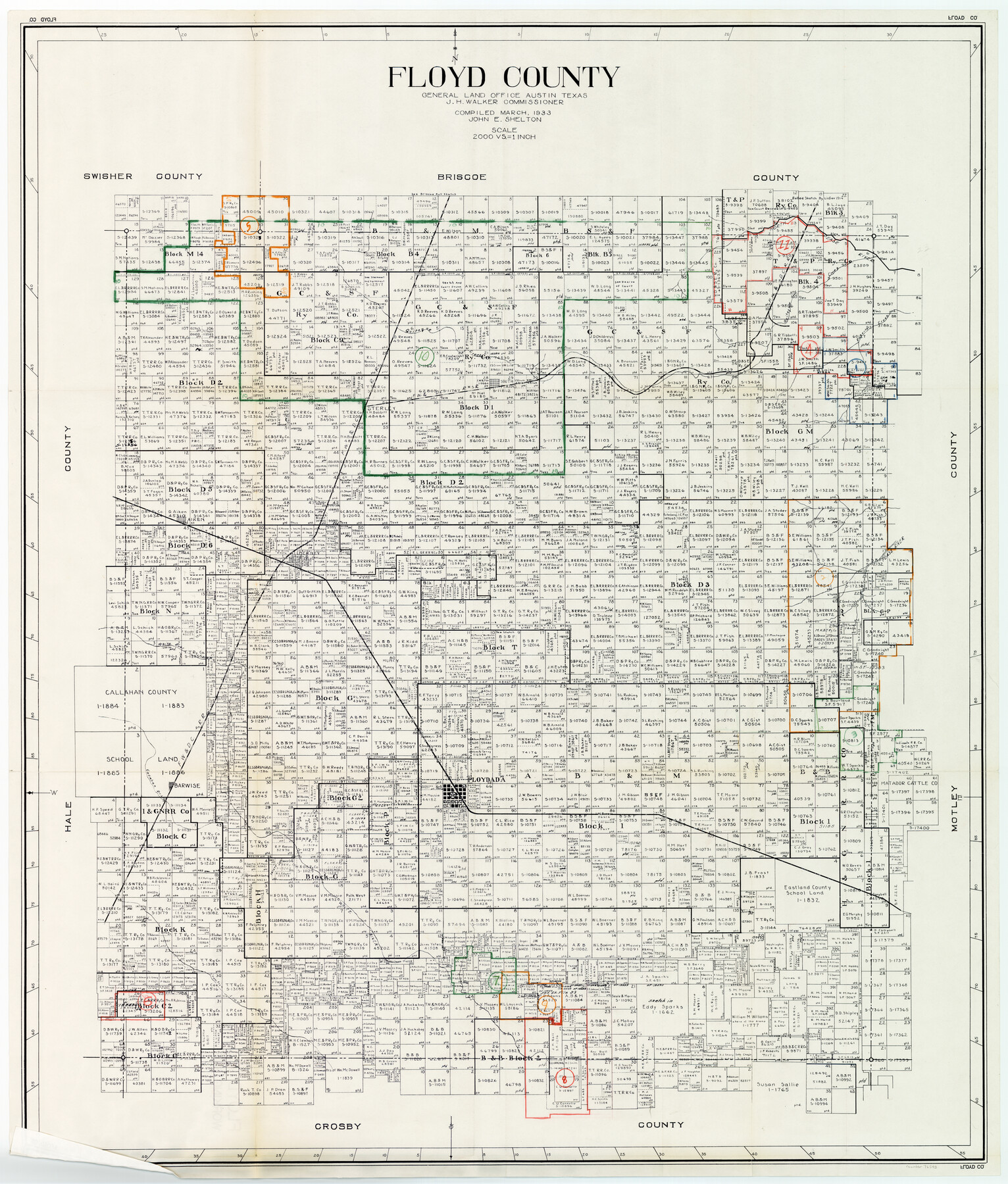
Floyd County Working Sketch Graphic Index
-
Map/Doc
76543
-
Collection
General Map Collection
-
Object Dates
3/1933 (Creation Date)
-
People and Organizations
John E. Shelton (Draftsman)
-
Counties
Floyd
-
Subjects
County Surveying Working Sketch
-
Height x Width
44.9 x 38.4 inches
114.1 x 97.5 cm
-
Scale
1" = 2000 varas
Part of: General Map Collection
Upton County Boundary File 1

Print $5.00
- Digital $50.00
Upton County Boundary File 1
Size 13.4 x 9.0 inches
Map/Doc 59506
Hardeman County Sketch File 29

Print $20.00
- Digital $50.00
Hardeman County Sketch File 29
1890
Size 12.9 x 8.2 inches
Map/Doc 25056
Flight Mission No. CGI-3N, Frame 48, Cameron County

Print $20.00
- Digital $50.00
Flight Mission No. CGI-3N, Frame 48, Cameron County
1954
Size 18.7 x 22.2 inches
Map/Doc 84554
Runnels County Sketch File 5a

Print $40.00
Runnels County Sketch File 5a
1883
Size 8.9 x 22.0 inches
Map/Doc 35438
Hardin County Sketch File 8

Print $8.00
- Digital $50.00
Hardin County Sketch File 8
1870
Size 12.6 x 8.1 inches
Map/Doc 25102
Williamson County Working Sketch 16

Print $20.00
- Digital $50.00
Williamson County Working Sketch 16
1984
Size 31.9 x 23.7 inches
Map/Doc 72576
Harris County Rolled Sketch 74

Print $20.00
- Digital $50.00
Harris County Rolled Sketch 74
Size 19.1 x 33.3 inches
Map/Doc 6112
The United States of Mexico

Print $20.00
- Digital $50.00
The United States of Mexico
1832
Size 15.4 x 12.8 inches
Map/Doc 93952
Ector County Working Sketch 33

Print $20.00
- Digital $50.00
Ector County Working Sketch 33
1982
Size 24.7 x 29.0 inches
Map/Doc 68876
Hockley County Sketch File 15

Print $6.00
- Digital $50.00
Hockley County Sketch File 15
1912
Size 11.4 x 8.9 inches
Map/Doc 26550
Foard County Rolled Sketch 13

Print $20.00
- Digital $50.00
Foard County Rolled Sketch 13
1958
Size 25.2 x 31.4 inches
Map/Doc 5887
[Sketch for Mineral Application 15559 - Hutchinson County, Canadian River]
![65680, [Sketch for Mineral Application 15559 - Hutchinson County, Canadian River], General Map Collection](https://historictexasmaps.com/wmedia_w700/maps/65680-1.tif.jpg)
Print $20.00
- Digital $50.00
[Sketch for Mineral Application 15559 - Hutchinson County, Canadian River]
1926
Size 12.0 x 13.2 inches
Map/Doc 65680
You may also like
Flight Mission No. BQR-22K, Frame 34, Brazoria County

Print $20.00
- Digital $50.00
Flight Mission No. BQR-22K, Frame 34, Brazoria County
1953
Size 18.7 x 22.5 inches
Map/Doc 84118
Flight Mission No. BRA-7M, Frame 182, Jefferson County

Print $20.00
- Digital $50.00
Flight Mission No. BRA-7M, Frame 182, Jefferson County
1953
Size 18.5 x 22.3 inches
Map/Doc 85550
Duval County Working Sketch 13

Print $20.00
- Digital $50.00
Duval County Working Sketch 13
1938
Size 27.8 x 32.5 inches
Map/Doc 68726
[Right of Way and Track Map, the Missouri, Kansas and Texas Ry. of Texas - Henrietta Division]
![64759, [Right of Way and Track Map, the Missouri, Kansas and Texas Ry. of Texas - Henrietta Division], General Map Collection](https://historictexasmaps.com/wmedia_w700/maps/64759.tif.jpg)
Print $20.00
- Digital $50.00
[Right of Way and Track Map, the Missouri, Kansas and Texas Ry. of Texas - Henrietta Division]
1918
Size 11.9 x 26.8 inches
Map/Doc 64759
Brazoria County Aerial Photograph Index Sheet 6

Print $20.00
- Digital $50.00
Brazoria County Aerial Photograph Index Sheet 6
1953
Size 23.8 x 19.3 inches
Map/Doc 83668
Culberson County Rolled Sketch SL

Print $20.00
- Digital $50.00
Culberson County Rolled Sketch SL
1930
Size 19.1 x 24.7 inches
Map/Doc 5683
Flight Mission No. DIX-6P, Frame 127, Aransas County

Print $20.00
- Digital $50.00
Flight Mission No. DIX-6P, Frame 127, Aransas County
1956
Size 19.1 x 23.0 inches
Map/Doc 83833
[Texas and Pacific Railway Company, Block 44, Township One South]
![89845, [Texas and Pacific Railway Company, Block 44, Township One South], Twichell Survey Records](https://historictexasmaps.com/wmedia_w700/maps/89845-1.tif.jpg)
Print $40.00
- Digital $50.00
[Texas and Pacific Railway Company, Block 44, Township One South]
Size 42.0 x 59.2 inches
Map/Doc 89845
La Salle County Rolled Sketch 24

Print $20.00
- Digital $50.00
La Salle County Rolled Sketch 24
1955
Size 36.7 x 39.4 inches
Map/Doc 10655

Bee County Working Sketch 34

Print $20.00
- Digital $50.00
Bee County Working Sketch 34
1988
Size 46.3 x 43.6 inches
Map/Doc 67285
Garza County Sketch File 19

Print $20.00
- Digital $50.00
Garza County Sketch File 19
1905
Size 21.8 x 23.0 inches
Map/Doc 11546