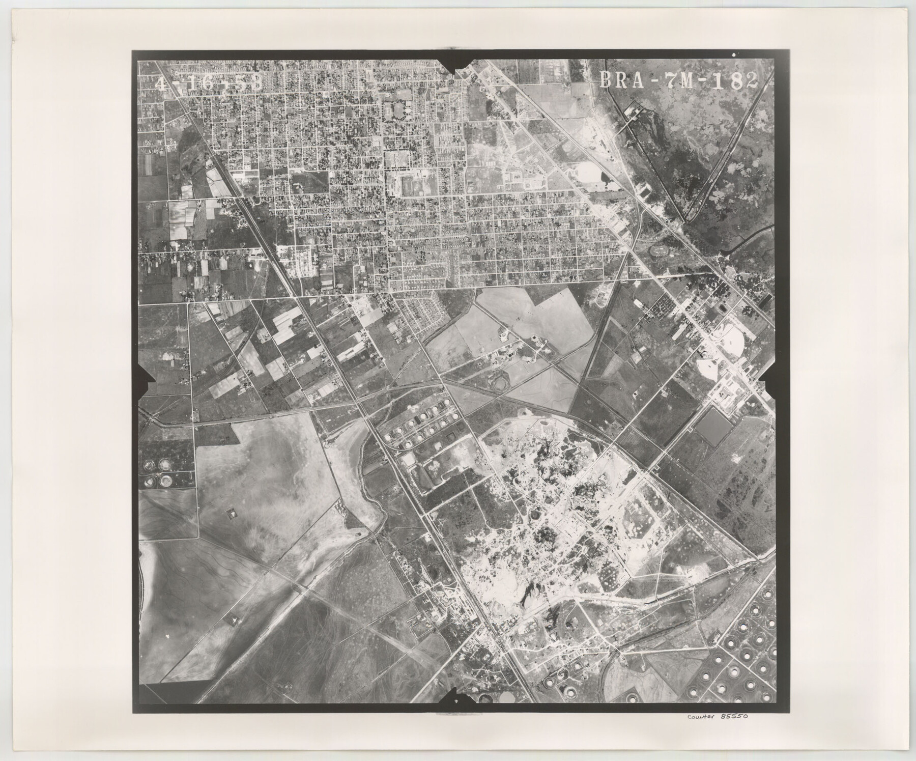
Flight Mission No. BRA-7M, Frame 182, Jefferson County
BRA-7M-182
-
Map/Doc
85550
-
Collection
General Map Collection
-
Object Dates
1953/4/16 (Creation Date)
-
People and Organizations
U. S. Department of Agriculture (Publisher)
-
Counties
Jefferson
-
Subjects
Aerial Photograph
-
Height x Width
18.5 x 22.3 inches
47.0 x 56.6 cm
-
Comments
Flown by Jack Ammann Photogrammetric Engineers of San Antonio, Texas.
Part of: General Map Collection
Andrews County

Print $40.00
- Digital $50.00
Andrews County
1951
Size 42.7 x 54.4 inches
Map/Doc 73067

Mills County Sketch File 23

Print $4.00
- Digital $50.00
Mills County Sketch File 23
Size 12.4 x 9.2 inches
Map/Doc 31672
Flight Mission No. BRA-7M, Frame 84, Jefferson County

Print $20.00
- Digital $50.00
Flight Mission No. BRA-7M, Frame 84, Jefferson County
1953
Size 18.6 x 22.3 inches
Map/Doc 85506
Victoria County Working Sketch 5

Print $20.00
- Digital $50.00
Victoria County Working Sketch 5
1944
Size 35.2 x 40.8 inches
Map/Doc 72275
Galveston County NRC Article 33.136 Sketch 69

Print $76.00
- Digital $50.00
Galveston County NRC Article 33.136 Sketch 69
2012
Size 24.0 x 36.0 inches
Map/Doc 94669
Map of Dimmit County

Print $20.00
- Digital $50.00
Map of Dimmit County
1875
Size 21.9 x 24.0 inches
Map/Doc 3489
Ride the Texas Mountain Trail [Recto]
![94164, Ride the Texas Mountain Trail [Recto], General Map Collection](https://historictexasmaps.com/wmedia_w700/maps/94164.tif.jpg)
Ride the Texas Mountain Trail [Recto]
1968
Size 18.4 x 24.3 inches
Map/Doc 94164
El Paso County Boundary File 14a

Print $7.00
- Digital $50.00
El Paso County Boundary File 14a
Size 11.1 x 8.7 inches
Map/Doc 53183
Clay County Sketch File 19

Print $5.00
- Digital $50.00
Clay County Sketch File 19
Size 9.2 x 9.9 inches
Map/Doc 18429
Reagan County Working Sketch 39

Print $20.00
- Digital $50.00
Reagan County Working Sketch 39
1971
Size 22.5 x 36.1 inches
Map/Doc 71881
Gregg County Working Sketch 15

Print $20.00
- Digital $50.00
Gregg County Working Sketch 15
1941
Size 24.8 x 29.5 inches
Map/Doc 63282
You may also like
Walker County Working Sketch 18

Print $20.00
- Digital $50.00
Walker County Working Sketch 18
1991
Size 29.4 x 31.5 inches
Map/Doc 72298
Jack County Sketch File 16

Print $4.00
- Digital $50.00
Jack County Sketch File 16
1877
Size 7.9 x 12.8 inches
Map/Doc 27549
Flight Mission No. BQY-15M, Frame 3, Harris County

Print $20.00
- Digital $50.00
Flight Mission No. BQY-15M, Frame 3, Harris County
1953
Size 18.7 x 22.5 inches
Map/Doc 85301
Shelby County Working Sketch 20

Print $20.00
- Digital $50.00
Shelby County Working Sketch 20
1970
Size 28.0 x 22.8 inches
Map/Doc 63873
Kenedy County Rolled Sketch 15

Print $15.00
- Digital $50.00
Kenedy County Rolled Sketch 15
1942
Size 10.2 x 15.2 inches
Map/Doc 46426
Goliad County Sketch File 25

Print $6.00
- Digital $50.00
Goliad County Sketch File 25
1856
Size 12.3 x 7.8 inches
Map/Doc 24305
Mexico and Guatimala

Print $20.00
- Digital $50.00
Mexico and Guatimala
1828
Size 9.4 x 11.4 inches
Map/Doc 97524
[Sketch for Mineral Application 13439 - Bed Lost Lake, Walle Merritt]
![65577, [Sketch for Mineral Application 13439 - Bed Lost Lake, Walle Merritt], General Map Collection](https://historictexasmaps.com/wmedia_w700/maps/65577.tif.jpg)
Print $20.00
- Digital $50.00
[Sketch for Mineral Application 13439 - Bed Lost Lake, Walle Merritt]
1925
Size 31.1 x 29.9 inches
Map/Doc 65577
Travis County

Print $40.00
- Digital $50.00
Travis County
1880
Size 62.1 x 50.2 inches
Map/Doc 87935
[M. B. & B. Blocks A, B and C and various County School Land Leagues]
![90282, [M. B. & B. Blocks A, B and C and various County School Land Leagues], Twichell Survey Records](https://historictexasmaps.com/wmedia_w700/maps/90282-1.tif.jpg)
Print $20.00
- Digital $50.00
[M. B. & B. Blocks A, B and C and various County School Land Leagues]
Size 15.8 x 19.0 inches
Map/Doc 90282
Flight Mission No. BRA-7M, Frame 142, Jefferson County

Print $20.00
- Digital $50.00
Flight Mission No. BRA-7M, Frame 142, Jefferson County
1953
Size 18.6 x 22.5 inches
Map/Doc 85536
Garza County Sketch File 4a

Print $4.00
- Digital $50.00
Garza County Sketch File 4a
1883
Size 14.2 x 8.8 inches
Map/Doc 24048