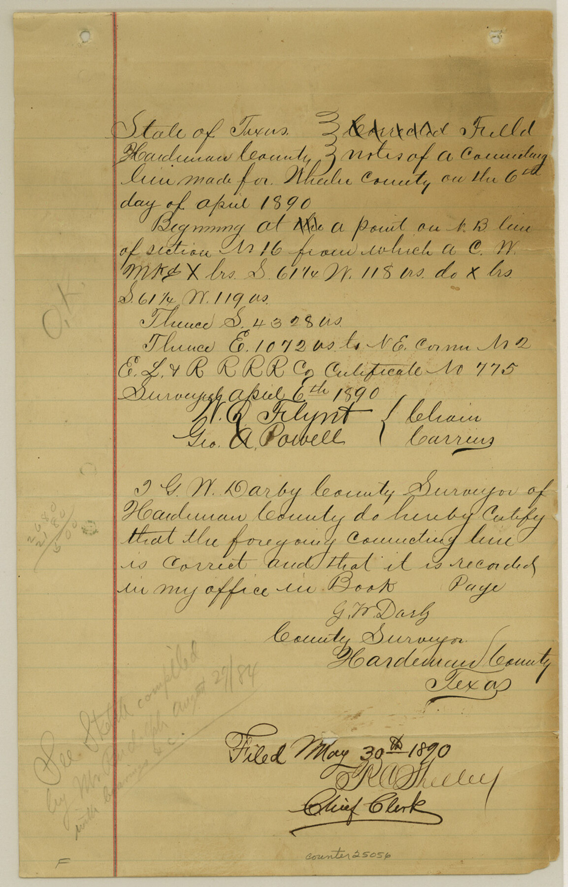
Hardeman County Sketch File 29
[Connecting line field notes along north county line]
-
Map/Doc
25056
-
Collection
General Map Collection
-
Object Dates
1890/4/6 (Survey Date)
1890/5/30 (File Date)
1890/5/5 (Survey Date)
1890/5/21 (Survey Date)
1890/4/5 (Creation Date)
1890/3/19 (Survey Date)
-
People and Organizations
W.Q. Flynt (Chainman)
George A. Powell (Chainman)
G.W. Darby (Surveyor/Engineer)
R.C. Shelley (GLO Clerk)
O.W. Beau (Chainman)
Bob Hoskinson (Chainman)
A.S. Smith (Chainman)
J.J. Murrell (Chainman)
R.B. Wilson (Chainman)
-
Counties
Hardeman
-
Subjects
Surveying Sketch File
-
Height x Width
12.9 x 8.2 inches
32.8 x 20.8 cm
-
Medium
paper, manuscript
-
Comments
See Hardeman County Rolled Sketch 15 (6072) for sketch.
Related maps
Hardeman County Rolled Sketch 15

Print $20.00
- Digital $50.00
Hardeman County Rolled Sketch 15
1890
Size 18.0 x 23.0 inches
Map/Doc 6072
Part of: General Map Collection
Kinney County Working Sketch 56

Print $40.00
- Digital $50.00
Kinney County Working Sketch 56
1987
Size 40.5 x 62.8 inches
Map/Doc 70238

Sketch of surveys on Deer Creek, Milam District

Print $2.00
- Digital $50.00
Sketch of surveys on Deer Creek, Milam District
1846
Size 7.8 x 10.9 inches
Map/Doc 76046
Rockwall County Boundary File 4a

Print $10.00
- Digital $50.00
Rockwall County Boundary File 4a
Size 11.2 x 8.8 inches
Map/Doc 58399
Hunt County Sketch File 14

Print $4.00
- Digital $50.00
Hunt County Sketch File 14
1851
Size 8.5 x 15.2 inches
Map/Doc 27107
Anderson County Sketch File 32

Print $4.00
- Digital $50.00
Anderson County Sketch File 32
2002
Size 11.3 x 8.8 inches
Map/Doc 78312
Presidio County Working Sketch 118

Print $20.00
- Digital $50.00
Presidio County Working Sketch 118
1983
Size 47.4 x 41.6 inches
Map/Doc 71795
Cooke County Sketch File 42

Print $8.00
- Digital $50.00
Cooke County Sketch File 42
1940
Size 14.3 x 8.8 inches
Map/Doc 19316
Terry County Sketch File 17

Print $5.00
- Digital $50.00
Terry County Sketch File 17
1956
Size 27.7 x 24.7 inches
Map/Doc 12429
[San Antonio & Aransas Pass Through Gonzales County]
![64288, [San Antonio & Aransas Pass Through Gonzales County], General Map Collection](https://historictexasmaps.com/wmedia_w700/maps/64288.tif.jpg)
Print $20.00
- Digital $50.00
[San Antonio & Aransas Pass Through Gonzales County]
1880
Size 11.4 x 30.7 inches
Map/Doc 64288
Dickens County

Print $20.00
- Digital $50.00
Dickens County
1895
Size 22.8 x 18.7 inches
Map/Doc 3484
Harris County Working Sketch 102

Print $20.00
- Digital $50.00
Harris County Working Sketch 102
1980
Size 33.6 x 18.9 inches
Map/Doc 65994
You may also like
Edwards County Working Sketch 43

Print $20.00
- Digital $50.00
Edwards County Working Sketch 43
1950
Size 20.3 x 27.7 inches
Map/Doc 68919
Cochran County Working Sketch 3

Print $20.00
- Digital $50.00
Cochran County Working Sketch 3
1979
Size 33.4 x 30.9 inches
Map/Doc 68014
Leon County Working Sketch 40

Print $20.00
- Digital $50.00
Leon County Working Sketch 40
1980
Size 31.4 x 20.5 inches
Map/Doc 70439
Right of Way & Track Map San Antonio & Aransas Pass Railway Co.

Print $40.00
- Digital $50.00
Right of Way & Track Map San Antonio & Aransas Pass Railway Co.
1919
Size 25.6 x 57.0 inches
Map/Doc 64025

Stephens County Working Sketch 2

Print $20.00
- Digital $50.00
Stephens County Working Sketch 2
1918
Size 17.1 x 21.1 inches
Map/Doc 63945
Map of the Lands Surveyed by the Memphis, El Paso & Pacific R.R. Company

Print $20.00
- Digital $50.00
Map of the Lands Surveyed by the Memphis, El Paso & Pacific R.R. Company
1859
Size 15.8 x 19.0 inches
Map/Doc 4844
[Gulf Coast of Texas]
![72704, [Gulf Coast of Texas], General Map Collection](https://historictexasmaps.com/wmedia_w700/maps/72704.tif.jpg)
Print $20.00
- Digital $50.00
[Gulf Coast of Texas]
1881
Size 28.7 x 18.2 inches
Map/Doc 72704
Morris County Rolled Sketch 2A

Print $20.00
- Digital $50.00
Morris County Rolled Sketch 2A
Size 24.0 x 18.8 inches
Map/Doc 10238
[Map Showing Panhandle Counties in Texas]
![2087, [Map Showing Panhandle Counties in Texas], General Map Collection](https://historictexasmaps.com/wmedia_w700/maps/2087.tif.jpg)
Print $20.00
- Digital $50.00
[Map Showing Panhandle Counties in Texas]
1876
Size 27.3 x 27.9 inches
Map/Doc 2087
Sutton County

Print $40.00
- Digital $50.00
Sutton County
1941
Size 43.9 x 56.1 inches
Map/Doc 73296
Flight Mission No. BQR-16K, Frame 37, Brazoria County

Print $20.00
- Digital $50.00
Flight Mission No. BQR-16K, Frame 37, Brazoria County
1952
Size 18.6 x 22.3 inches
Map/Doc 84104