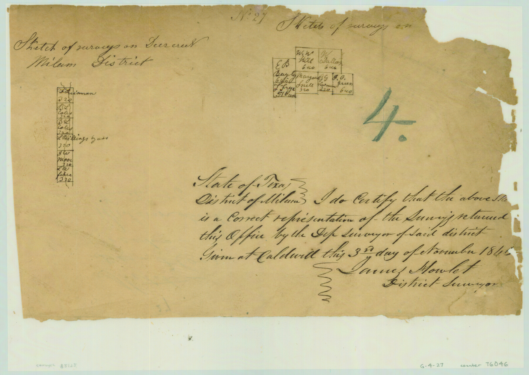
Sketch of surveys on Deer Creek, Milam District
Atlas G, Page 4, Sketch 27 (G-4-27)
G-4-27
-
Map/Doc
76046
-
Collection
General Map Collection
-
Object Dates
1846 (Creation Date)
-
People and Organizations
James Howlet (Surveyor/Engineer)
-
Counties
McLennan Bell Falls
-
Subjects
Atlas
-
Height x Width
7.8 x 10.9 inches
19.8 x 27.7 cm
-
Medium
paper, manuscript
-
Comments
Conserved in 2003.
Part of: General Map Collection
Blanco County Working Sketch 24

Print $20.00
- Digital $50.00
Blanco County Working Sketch 24
1963
Size 30.2 x 31.2 inches
Map/Doc 67384
Calhoun County NRC Article 33.136 Sketch 14

Print $24.00
Calhoun County NRC Article 33.136 Sketch 14
2023
Map/Doc 97273
Hale County Sketch File E

Print $20.00
- Digital $50.00
Hale County Sketch File E
1902
Size 15.2 x 21.5 inches
Map/Doc 11601
Map of Briscoe County

Print $20.00
- Digital $50.00
Map of Briscoe County
1885
Size 24.4 x 20.1 inches
Map/Doc 3334
Presidio County Rolled Sketch 99

Print $20.00
- Digital $50.00
Presidio County Rolled Sketch 99
Size 38.7 x 33.6 inches
Map/Doc 9784
Limestone County

Print $40.00
- Digital $50.00
Limestone County
1922
Size 50.6 x 36.2 inches
Map/Doc 73342

Aransas County Sketch File 26

Print $28.00
- Digital $50.00
Aransas County Sketch File 26
1896
Size 5.2 x 4.7 inches
Map/Doc 13219
Chambers County Aerial Photograph Index Sheet 2

Print $20.00
- Digital $50.00
Chambers County Aerial Photograph Index Sheet 2
1956
Size 19.4 x 15.7 inches
Map/Doc 83683
Flight Mission No. BRA-7M, Frame 74, Jefferson County

Print $20.00
- Digital $50.00
Flight Mission No. BRA-7M, Frame 74, Jefferson County
1953
Size 18.6 x 22.4 inches
Map/Doc 85496
Supreme Court of the United States, October Term, 1923, No. 15, Original - The State of Oklahoma, Complainant vs. The State of Texas, Defendant, The United States, Intervener; Report of the Boundary Commissioners

Print $20.00
- Digital $50.00
Supreme Court of the United States, October Term, 1923, No. 15, Original - The State of Oklahoma, Complainant vs. The State of Texas, Defendant, The United States, Intervener; Report of the Boundary Commissioners
1923
Size 46.4 x 33.4 inches
Map/Doc 75122
Fort Bend Co.

Print $20.00
- Digital $50.00
Fort Bend Co.
1931
Size 40.5 x 41.3 inches
Map/Doc 77282
You may also like
General Highway Map, Navarro County, Texas

Print $20.00
General Highway Map, Navarro County, Texas
1939
Size 24.7 x 18.4 inches
Map/Doc 79206
Nolan County Boundary File 1

Print $60.00
- Digital $50.00
Nolan County Boundary File 1
Size 8.8 x 3.9 inches
Map/Doc 57617
Runnels County Sketch File 28

Print $6.00
Runnels County Sketch File 28
1949
Size 11.3 x 8.8 inches
Map/Doc 35493
General Highway Map. Detail of Cities and Towns in Dallas County, Texas [Dallas and vicinity]
![79431, General Highway Map. Detail of Cities and Towns in Dallas County, Texas [Dallas and vicinity], Texas State Library and Archives](https://historictexasmaps.com/wmedia_w700/maps/79431.tif.jpg)
Print $20.00
General Highway Map. Detail of Cities and Towns in Dallas County, Texas [Dallas and vicinity]
1961
Size 18.1 x 24.4 inches
Map/Doc 79431
Duval County Boundary File 3

Print $14.00
- Digital $50.00
Duval County Boundary File 3
Size 8.6 x 3.9 inches
Map/Doc 52719
![91820, [Block M-19], Twichell Survey Records](https://historictexasmaps.com/wmedia_w700/maps/91820-1.tif.jpg)
Fort Bend County Working Sketch 9

Print $20.00
- Digital $50.00
Fort Bend County Working Sketch 9
1932
Size 38.7 x 16.0 inches
Map/Doc 69215
Matagorda County Working Sketch 14

Print $40.00
- Digital $50.00
Matagorda County Working Sketch 14
1950
Size 42.9 x 50.5 inches
Map/Doc 70872
[H. & T. C. Blocks 47 1/2 and 48, Capitol Lands]
![90639, [H. & T. C. Blocks 47 1/2 and 48, Capitol Lands], Twichell Survey Records](https://historictexasmaps.com/wmedia_w700/maps/90639-1.tif.jpg)
Print $20.00
- Digital $50.00
[H. & T. C. Blocks 47 1/2 and 48, Capitol Lands]
Size 19.9 x 24.8 inches
Map/Doc 90639
Falls County Sketch File 31

Print $4.00
- Digital $50.00
Falls County Sketch File 31
1881
Size 14.5 x 8.8 inches
Map/Doc 22439
Correct map of the Chicago, Burlington and Quincy Rail Road and its principal connecting lines

Print $20.00
- Digital $50.00
Correct map of the Chicago, Burlington and Quincy Rail Road and its principal connecting lines
1881
Size 27.7 x 38.6 inches
Map/Doc 93956
Brewster County Rolled Sketch 101

Print $20.00
- Digital $50.00
Brewster County Rolled Sketch 101
1944
Size 34.6 x 42.4 inches
Map/Doc 8924