Morris County Rolled Sketch 2A
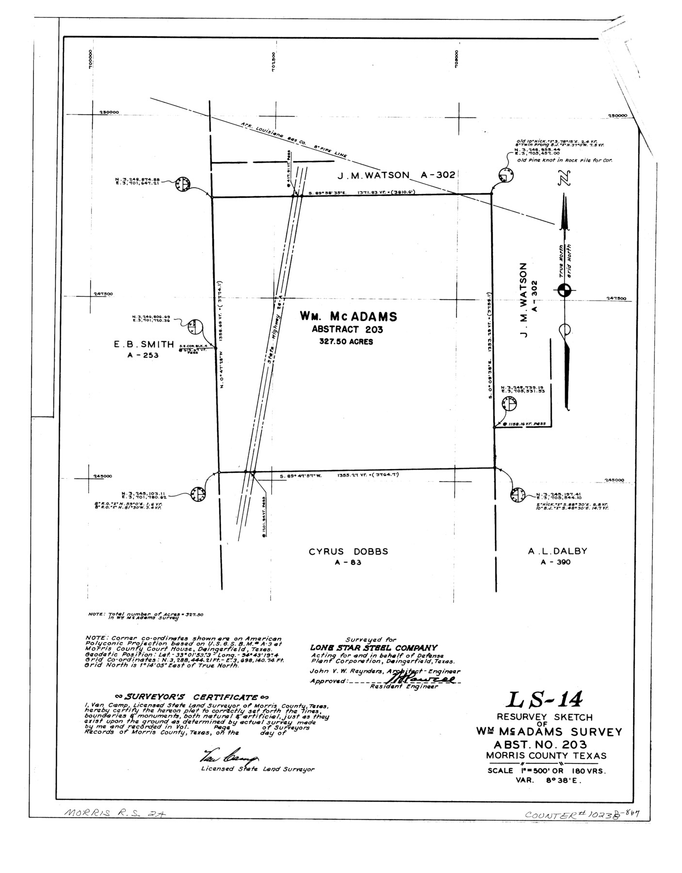
LS-14 - Resurvey sketch of Wm. McAdams survey, abst. no. 203, Morris County, Texas
-
Map/Doc
10238
-
Collection
General Map Collection
-
People and Organizations
Van Camp (Surveyor/Engineer)
-
Counties
Morris
-
Subjects
Surveying Rolled Sketch
-
Height x Width
24.0 x 18.8 inches
61.0 x 47.8 cm
-
Medium
linen, manuscript
-
Scale
1" = 180 varas
-
Comments
See Morris County Rolled Sketch 2 (9550) for map of all retracement surveys made for Lone Star Steel Company.
Related maps
Morris County Rolled Sketch 2

Print $40.00
- Digital $50.00
Morris County Rolled Sketch 2
1944
Size 59.4 x 43.5 inches
Map/Doc 9550
Part of: General Map Collection

Flight Mission No. DAG-28K, Frame 22, Matagorda County

Print $20.00
- Digital $50.00
Flight Mission No. DAG-28K, Frame 22, Matagorda County
1953
Size 18.4 x 22.3 inches
Map/Doc 86590
Rockwall County Boundary File 4a

Print $10.00
- Digital $50.00
Rockwall County Boundary File 4a
Size 11.2 x 8.8 inches
Map/Doc 58399
Terry County Boundary File 4a

Print $70.00
- Digital $50.00
Terry County Boundary File 4a
Size 11.4 x 8.8 inches
Map/Doc 59249
Terrell County Sketch File 7

Print $20.00
- Digital $50.00
Terrell County Sketch File 7
1890
Size 13.1 x 16.2 inches
Map/Doc 12418
McCulloch County Rolled Sketch 3

Print $40.00
- Digital $50.00
McCulloch County Rolled Sketch 3
Size 85.5 x 20.8 inches
Map/Doc 9497

Flight Mission No. CRC-6R, Frame 39, Chambers County

Print $20.00
- Digital $50.00
Flight Mission No. CRC-6R, Frame 39, Chambers County
1956
Size 18.7 x 22.5 inches
Map/Doc 84972
[Surveys along the San Jacinto River]
![62, [Surveys along the San Jacinto River], General Map Collection](https://historictexasmaps.com/wmedia_w700/maps/62.tif.jpg)
Print $3.00
- Digital $50.00
[Surveys along the San Jacinto River]
1841
Size 10.7 x 14.5 inches
Map/Doc 62
Hockley County

Print $20.00
- Digital $50.00
Hockley County
1954
Size 42.7 x 38.2 inches
Map/Doc 73181
Briscoe County Sketch File 5

Print $40.00
- Digital $50.00
Briscoe County Sketch File 5
Size 29.8 x 26.5 inches
Map/Doc 10994
Limestone County Working Sketch 13

Print $20.00
- Digital $50.00
Limestone County Working Sketch 13
1922
Size 11.8 x 11.8 inches
Map/Doc 70563
You may also like
The Judicial District/County of Lavaca. Abolished, Spring 1842

Print $20.00
The Judicial District/County of Lavaca. Abolished, Spring 1842
2020
Size 14.6 x 21.7 inches
Map/Doc 96332
Subdivision of Halsell Cattle Company's Sod House Pasture Situated in Lamb County, Texas

Print $20.00
- Digital $50.00
Subdivision of Halsell Cattle Company's Sod House Pasture Situated in Lamb County, Texas
Size 37.3 x 28.2 inches
Map/Doc 92169
Erath County Sketch File 3

Print $4.00
- Digital $50.00
Erath County Sketch File 3
1853
Size 13.0 x 8.3 inches
Map/Doc 22255
The Texas and Pacific Ry. Co., Station Map, Loraine, Texas

Print $20.00
- Digital $50.00
The Texas and Pacific Ry. Co., Station Map, Loraine, Texas
Size 11.6 x 18.6 inches
Map/Doc 64683
Mitchell County Sketch File 3

Print $4.00
- Digital $50.00
Mitchell County Sketch File 3
1902
Size 9.2 x 8.4 inches
Map/Doc 31690
Upton County Sketch File 34

Print $40.00
- Digital $50.00
Upton County Sketch File 34
1941
Size 16.2 x 12.2 inches
Map/Doc 38884
Coast Chart No. 210 - Aransas Pass and Corpus Christi Bay with the coast to latitude 27° 12', Texas

Print $20.00
- Digital $50.00
Coast Chart No. 210 - Aransas Pass and Corpus Christi Bay with the coast to latitude 27° 12', Texas
1887
Size 23.4 x 29.4 inches
Map/Doc 73443
[North line of T. & P. Block 31, Township 6N]
![90554, [North line of T. & P. Block 31, Township 6N], Twichell Survey Records](https://historictexasmaps.com/wmedia_w700/maps/90554-1.tif.jpg)
Print $2.00
- Digital $50.00
[North line of T. & P. Block 31, Township 6N]
Size 7.5 x 4.7 inches
Map/Doc 90554

Flight Mission No. DAH-10M, Frame 43, Orange County

Print $20.00
- Digital $50.00
Flight Mission No. DAH-10M, Frame 43, Orange County
1953
Size 18.6 x 22.6 inches
Map/Doc 86878
Crane County Working Sketch Graphic Index, Sheet B

Print $20.00
- Digital $50.00
Crane County Working Sketch Graphic Index, Sheet B
1945
Size 44.8 x 33.6 inches
Map/Doc 76508
Aransas County Working Sketch 16

Print $40.00
- Digital $50.00
Aransas County Working Sketch 16
1965
Size 55.3 x 43.1 inches
Map/Doc 67183