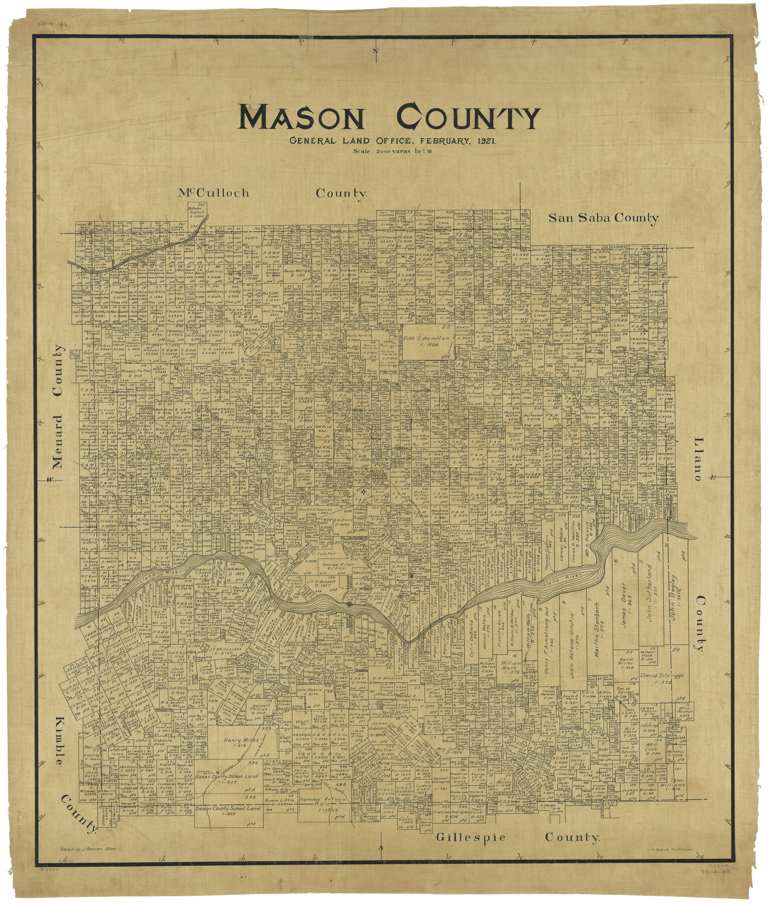
Mason County
RM-4-157
-
Map/Doc
1890
-
Collection
General Map Collection
-
Object Dates
2/1921 (Creation Date)
-
People and Organizations
John D. Hedick (Draftsman)
J. Bascom Giles (Tracer)
-
Counties
Mason
-
Subjects
County
-
Height x Width
46.2 x 39.1 inches
117.4 x 99.3 cm
Part of: General Map Collection
Eastland County Working Sketch 15

Print $20.00
- Digital $50.00
Eastland County Working Sketch 15
1919
Size 21.2 x 23.0 inches
Map/Doc 68796
Flight Mission No. DAG-23K, Frame 164, Matagorda County

Print $20.00
- Digital $50.00
Flight Mission No. DAG-23K, Frame 164, Matagorda County
1953
Size 18.6 x 22.3 inches
Map/Doc 86502
Guadalupe County Working Sketch 11

Print $40.00
- Digital $50.00
Guadalupe County Working Sketch 11
1972
Size 67.7 x 45.0 inches
Map/Doc 63320
The History of Texas; or the Emigrant's, Farmer's, and Politician's Guide to the Character, Climate, Soil and Productions of that Country: Geographically Arranged from Personal Observation and Experience

The History of Texas; or the Emigrant's, Farmer's, and Politician's Guide to the Character, Climate, Soil and Productions of that Country: Geographically Arranged from Personal Observation and Experience
1836
Size 7.6 x 9.1 inches
Map/Doc 94038
Roberts County Working Sketch 15

Print $20.00
- Digital $50.00
Roberts County Working Sketch 15
1975
Size 40.5 x 38.7 inches
Map/Doc 63541
Presidio County Working Sketch 28

Print $20.00
- Digital $50.00
Presidio County Working Sketch 28
1945
Size 19.9 x 13.4 inches
Map/Doc 71704
Val Verde County Working Sketch 7

Print $20.00
- Digital $50.00
Val Verde County Working Sketch 7
1915
Size 21.9 x 19.5 inches
Map/Doc 72142
Starr County Rolled Sketch 43

Print $20.00
- Digital $50.00
Starr County Rolled Sketch 43
1982
Size 36.1 x 30.9 inches
Map/Doc 7836

Flight Mission No. BQR-9K, Frame 44, Brazoria County

Print $20.00
- Digital $50.00
Flight Mission No. BQR-9K, Frame 44, Brazoria County
1952
Size 18.7 x 22.3 inches
Map/Doc 84048
Polk County Sketch File 25

Print $46.00
- Digital $50.00
Polk County Sketch File 25
Size 5.7 x 28.2 inches
Map/Doc 34176
Burleson County Sketch File 8

Print $6.00
- Digital $50.00
Burleson County Sketch File 8
Size 8.7 x 5.3 inches
Map/Doc 16654
You may also like
Houston County Working Sketch 6

Print $20.00
- Digital $50.00
Houston County Working Sketch 6
1933
Size 37.1 x 30.8 inches
Map/Doc 66236
Map of Texas With Parts of the Adjoining States

Print $20.00
Map of Texas With Parts of the Adjoining States
1837
Size 29.9 x 25.2 inches
Map/Doc 88998
Rand, McNally & Co.'s Texas

Print $20.00
- Digital $50.00
Rand, McNally & Co.'s Texas
1887
Size 27.2 x 30.7 inches
Map/Doc 95884
Shackelford County Boundary File 2

Print $88.00
- Digital $50.00
Shackelford County Boundary File 2
Size 8.7 x 5.3 inches
Map/Doc 58633
Kimble County Working Sketch 61

Print $20.00
- Digital $50.00
Kimble County Working Sketch 61
1964
Size 23.4 x 21.5 inches
Map/Doc 70129
Austin County Sketch File 2

Print $4.00
- Digital $50.00
Austin County Sketch File 2
Size 8.2 x 6.3 inches
Map/Doc 13855
[Block M-23 and vicinity]
![91148, [Block M-23 and vicinity], Twichell Survey Records](https://historictexasmaps.com/wmedia_w700/maps/91148-1.tif.jpg)
Print $3.00
- Digital $50.00
[Block M-23 and vicinity]
Size 11.1 x 13.6 inches
Map/Doc 91148
[Sketch Showing Wm. T. Brewer, John R. Taylor, Wm. F. Butler, Timothy DeVore, L. M. Thorn and adjoining surveys]
![90231, [Sketch Showing Wm. T. Brewer, John R. Taylor, Wm. F. Butler, Timothy DeVore, L. M. Thorn and adjoining surveys], Twichell Survey Records](https://historictexasmaps.com/wmedia_w700/maps/90231-1.tif.jpg)
Print $20.00
- Digital $50.00
[Sketch Showing Wm. T. Brewer, John R. Taylor, Wm. F. Butler, Timothy DeVore, L. M. Thorn and adjoining surveys]
Size 27.2 x 19.4 inches
Map/Doc 90231
Freestone County Working Sketch 5

Print $40.00
- Digital $50.00
Freestone County Working Sketch 5
Size 37.8 x 67.4 inches
Map/Doc 69247
Galveston County Rolled Sketch 16

Print $20.00
- Digital $50.00
Galveston County Rolled Sketch 16
1952
Size 43.6 x 38.0 inches
Map/Doc 9078
Montgomery County Working Sketch 40

Print $20.00
- Digital $50.00
Montgomery County Working Sketch 40
1954
Size 18.1 x 23.3 inches
Map/Doc 71147
Limestone County Sketch File 10

Print $4.00
- Digital $50.00
Limestone County Sketch File 10
Size 8.4 x 9.4 inches
Map/Doc 30171