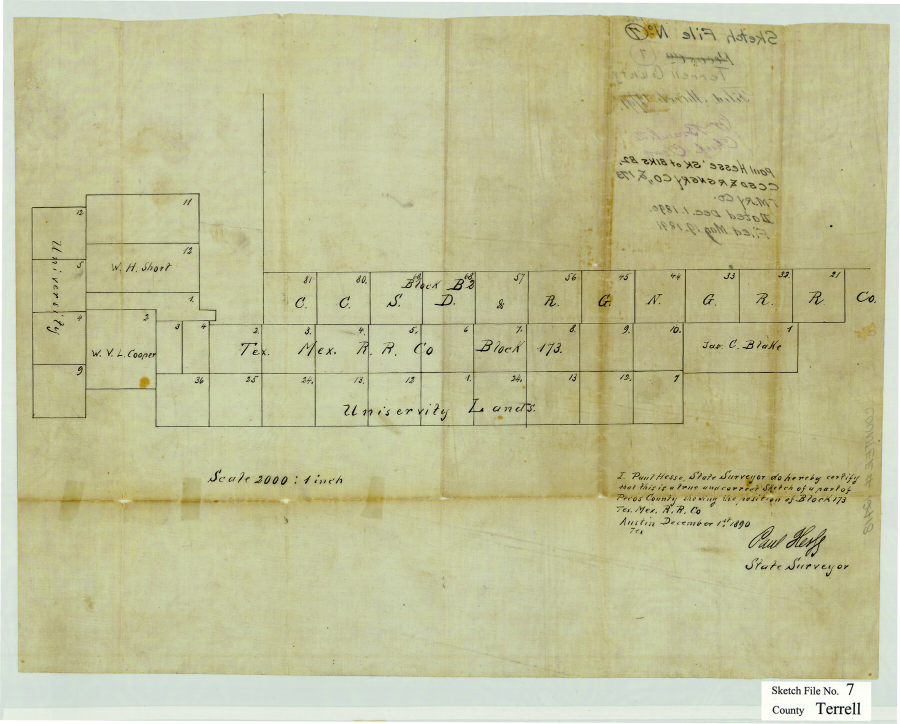
Terrell County Sketch File 7
[Sketch showing the position of Block 173, T. M. Ry. Co.]
-
Map/Doc
12418
-
Collection
General Map Collection
-
Object Dates
12/1/1890 (Creation Date)
5/19/1891 (File Date)
-
People and Organizations
Paul Hesse (Surveyor/Engineer)
-
Counties
Terrell
-
Subjects
Surveying Sketch File
-
Height x Width
13.1 x 16.2 inches
33.3 x 41.2 cm
-
Medium
paper, manuscript
-
Scale
1" = 2000 varas
Part of: General Map Collection
Culberson County Rolled Sketch 59

Print $40.00
- Digital $50.00
Culberson County Rolled Sketch 59
1974
Size 37.3 x 78.1 inches
Map/Doc 8760
Washington County

Print $20.00
- Digital $50.00
Washington County
1920
Size 32.5 x 47.2 inches
Map/Doc 16918
Houston County Sketch File 33

Print $20.00
- Digital $50.00
Houston County Sketch File 33
1894
Size 16.9 x 18.4 inches
Map/Doc 11790
[Surveys in Austin's Colony along the Navidad River; John P. Borden for Thos. H. Borden]
![77, [Surveys in Austin's Colony along the Navidad River; John P. Borden for Thos. H. Borden], General Map Collection](https://historictexasmaps.com/wmedia_w700/maps/77.tif.jpg)
Print $20.00
- Digital $50.00
[Surveys in Austin's Colony along the Navidad River; John P. Borden for Thos. H. Borden]
1831
Size 20.6 x 9.3 inches
Map/Doc 77
Harrison County Sketch File 9

Print $4.00
- Digital $50.00
Harrison County Sketch File 9
1862
Size 8.3 x 11.1 inches
Map/Doc 26048
Travis County Boundary File 30

Print $4.00
- Digital $50.00
Travis County Boundary File 30
Size 10.4 x 8.6 inches
Map/Doc 59469
Hudspeth County Rolled Sketch 69

Print $20.00
- Digital $50.00
Hudspeth County Rolled Sketch 69
1973
Size 12.2 x 20.8 inches
Map/Doc 7717
Hardin County Working Sketch 36

Print $40.00
- Digital $50.00
Hardin County Working Sketch 36
1981
Size 76.8 x 37.5 inches
Map/Doc 63434
Goliad County Working Sketch 19

Print $20.00
- Digital $50.00
Goliad County Working Sketch 19
1954
Size 31.5 x 31.8 inches
Map/Doc 63209
Denton County Working Sketch 35

Print $20.00
- Digital $50.00
Denton County Working Sketch 35
2008
Size 24.7 x 19.3 inches
Map/Doc 88821
Flight Mission No. BQR-16K, Frame 34, Brazoria County

Print $20.00
- Digital $50.00
Flight Mission No. BQR-16K, Frame 34, Brazoria County
1952
Size 18.7 x 22.4 inches
Map/Doc 84101
Pecos County Working Sketch 38

Print $20.00
- Digital $50.00
Pecos County Working Sketch 38
1939
Size 29.5 x 42.7 inches
Map/Doc 71510
You may also like
Padre Island National Seashore

Print $20.00
- Digital $50.00
Padre Island National Seashore
Size 16.0 x 21.7 inches
Map/Doc 60537
Sutton County Working Sketch 32

Print $20.00
- Digital $50.00
Sutton County Working Sketch 32
1933
Size 20.5 x 28.3 inches
Map/Doc 62375
Shackelford County Boundary File 4

Print $2.00
- Digital $50.00
Shackelford County Boundary File 4
Size 6.6 x 8.8 inches
Map/Doc 58660
Plat of Division 3 of Day Ranch Lands, Leaday, Texas

Print $20.00
- Digital $50.00
Plat of Division 3 of Day Ranch Lands, Leaday, Texas
Size 20.4 x 21.8 inches
Map/Doc 81514
Sterling County Working Sketch 1

Print $20.00
- Digital $50.00
Sterling County Working Sketch 1
1926
Size 30.3 x 29.6 inches
Map/Doc 63983
The Republic County of Jasper. January 29, 1842

Print $20.00
The Republic County of Jasper. January 29, 1842
2020
Size 19.5 x 21.7 inches
Map/Doc 96194
West Part of Liberty Co.

Print $40.00
- Digital $50.00
West Part of Liberty Co.
1977
Size 48.0 x 36.9 inches
Map/Doc 95570
Hidalgo County Sketch File 9

Print $40.00
- Digital $50.00
Hidalgo County Sketch File 9
1904
Size 8.8 x 5.7 inches
Map/Doc 26409
[Lgs. 192-195, 176-179]
![90254, [Lgs. 192-195, 176-179], Twichell Survey Records](https://historictexasmaps.com/wmedia_w700/maps/90254-1.tif.jpg)
Print $20.00
- Digital $50.00
[Lgs. 192-195, 176-179]
Size 18.2 x 25.2 inches
Map/Doc 90254
Garza County Sketch File 26

Print $4.00
- Digital $50.00
Garza County Sketch File 26
Size 10.9 x 8.5 inches
Map/Doc 24095
Jim Hogg County Working Sketch 12

Print $20.00
- Digital $50.00
Jim Hogg County Working Sketch 12
1984
Size 17.4 x 15.2 inches
Map/Doc 66598
Sutton County Sketch File 40

Print $20.00
- Digital $50.00
Sutton County Sketch File 40
Size 21.5 x 15.4 inches
Map/Doc 12390