Travis County Boundary File 30
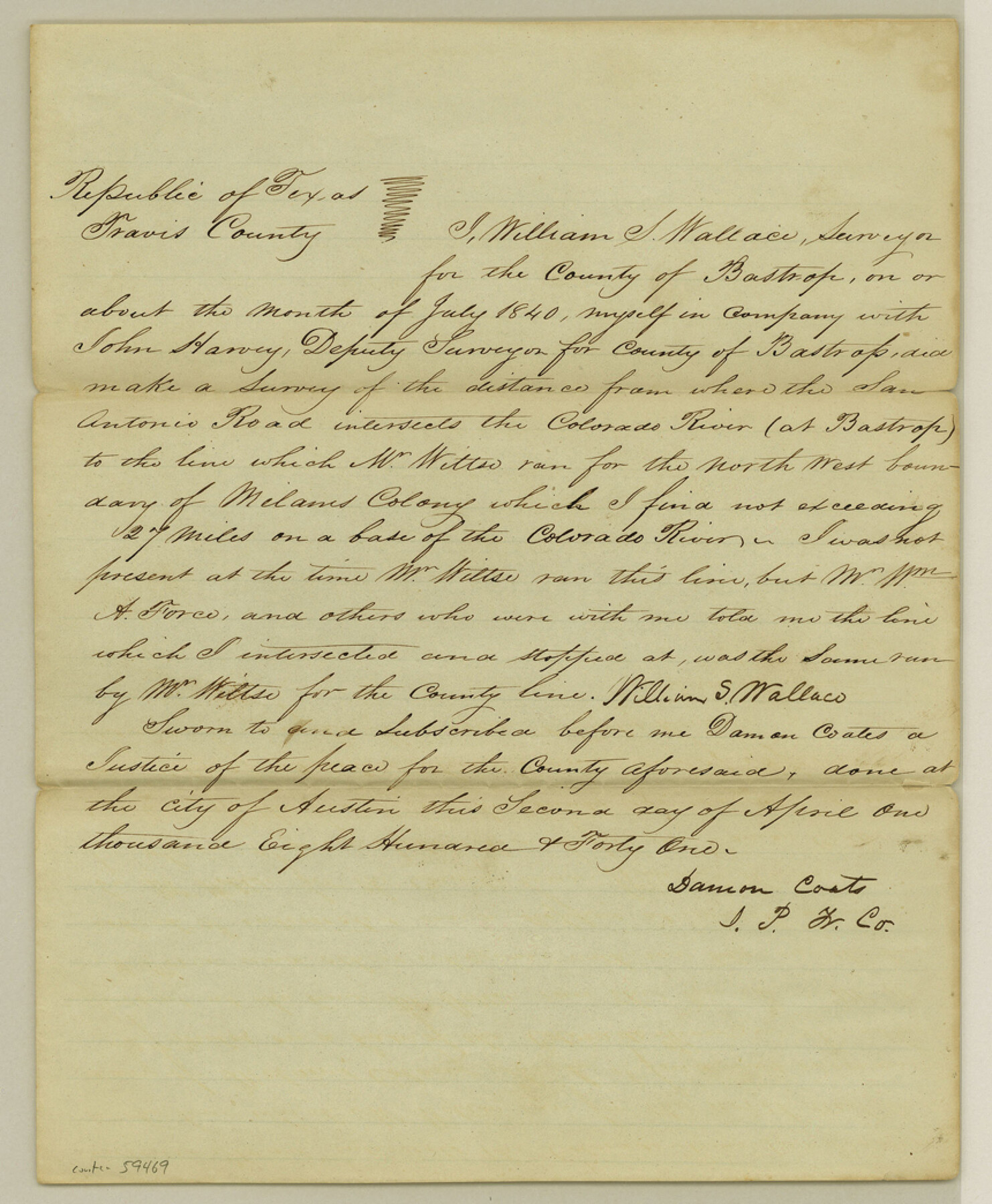
Travis & Bexar Oath of Wm. S. Wallace in relation to distance from San Antonio crossing at Bastrop to N. W. boundary of Milams Colony and run by Wiltse April 2nd, 1841
-
Map/Doc
59469
-
Collection
General Map Collection
-
Counties
Travis
-
Subjects
County Boundaries
-
Height x Width
10.4 x 8.6 inches
26.4 x 21.8 cm
Part of: General Map Collection
Harris County Rolled Sketch 26

Print $20.00
- Digital $50.00
Harris County Rolled Sketch 26
Size 28.2 x 41.3 inches
Map/Doc 6094
Tyler County Working Sketch 26

Print $20.00
- Digital $50.00
Tyler County Working Sketch 26
Size 27.7 x 46.3 inches
Map/Doc 69496
Stonewall County Sketch File 31

Print $77.00
- Digital $50.00
Stonewall County Sketch File 31
2001
Size 11.3 x 8.9 inches
Map/Doc 37308
Hemphill County Working Sketch 1

Print $20.00
- Digital $50.00
Hemphill County Working Sketch 1
1926
Size 15.1 x 19.7 inches
Map/Doc 66096
[Atchison, Topeka & Santa Fe from Paisano to south of Plata]
![64709, [Atchison, Topeka & Santa Fe from Paisano to south of Plata], General Map Collection](https://historictexasmaps.com/wmedia_w700/maps/64709.tif.jpg)
Print $40.00
- Digital $50.00
[Atchison, Topeka & Santa Fe from Paisano to south of Plata]
Size 32.3 x 120.8 inches
Map/Doc 64709
Flight Mission No. CGI-4N, Frame 192, Cameron County

Print $20.00
- Digital $50.00
Flight Mission No. CGI-4N, Frame 192, Cameron County
1955
Size 18.6 x 22.2 inches
Map/Doc 84695
Dickens County

Print $20.00
- Digital $50.00
Dickens County
1895
Size 22.8 x 18.7 inches
Map/Doc 3484
Colorado County Sketch File 19

Print $4.00
- Digital $50.00
Colorado County Sketch File 19
Size 9.1 x 7.5 inches
Map/Doc 18952
Sutton County Sketch File 53

Print $6.00
- Digital $50.00
Sutton County Sketch File 53
1948
Size 11.5 x 10.2 inches
Map/Doc 37532
Terrell County Sketch File 10

Print $44.00
- Digital $50.00
Terrell County Sketch File 10
1902
Size 9.7 x 4.6 inches
Map/Doc 37910
Falls County Sketch File 31

Print $4.00
- Digital $50.00
Falls County Sketch File 31
1881
Size 14.5 x 8.8 inches
Map/Doc 22439
Brazoria County Working Sketch 37

Print $40.00
- Digital $50.00
Brazoria County Working Sketch 37
1981
Size 43.5 x 66.0 inches
Map/Doc 67522
You may also like
Coryell County Rolled Sketch 3

Print $20.00
- Digital $50.00
Coryell County Rolled Sketch 3
1974
Size 24.6 x 36.4 inches
Map/Doc 5567
Flight Mission No. CRC-3R, Frame 44, Chambers County

Print $20.00
- Digital $50.00
Flight Mission No. CRC-3R, Frame 44, Chambers County
1956
Size 18.6 x 22.3 inches
Map/Doc 84817
Orange County Working Sketch 29

Print $40.00
- Digital $50.00
Orange County Working Sketch 29
1953
Size 32.9 x 50.0 inches
Map/Doc 71361
Cooke County Working Sketch 7

Print $20.00
- Digital $50.00
Cooke County Working Sketch 7
1939
Size 25.1 x 33.7 inches
Map/Doc 68244
Roberts County Working Sketch 5

Print $20.00
- Digital $50.00
Roberts County Working Sketch 5
1949
Size 40.4 x 40.1 inches
Map/Doc 63531
Van Zandt County Boundary File 1

Print $32.00
- Digital $50.00
Van Zandt County Boundary File 1
Size 13.0 x 8.5 inches
Map/Doc 59626
Fractional Township No. 8 South Range No. 19 East of the Indian Meridian, Indian Territory

Print $20.00
- Digital $50.00
Fractional Township No. 8 South Range No. 19 East of the Indian Meridian, Indian Territory
1897
Size 19.1 x 24.2 inches
Map/Doc 75234
Presidio County Sketch File 53

Print $24.00
- Digital $50.00
Presidio County Sketch File 53
1928
Size 16.6 x 8.8 inches
Map/Doc 34610
[Blocks 2, M3, M20, G. & M. Block 22 and others in the vicinity]
![91803, [Blocks 2, M3, M20, G. & M. Block 22 and others in the vicinity], Twichell Survey Records](https://historictexasmaps.com/wmedia_w700/maps/91803-1.tif.jpg)
Print $20.00
- Digital $50.00
[Blocks 2, M3, M20, G. & M. Block 22 and others in the vicinity]
Size 19.0 x 23.2 inches
Map/Doc 91803
Pecos County Sketch File 19

Print $4.00
- Digital $50.00
Pecos County Sketch File 19
Size 14.2 x 8.8 inches
Map/Doc 33668
Upton County Rolled Sketch 26

Print $20.00
- Digital $50.00
Upton County Rolled Sketch 26
1942
Size 35.7 x 37.2 inches
Map/Doc 10045
Baylor County Rolled Sketch WAJ

Print $20.00
- Digital $50.00
Baylor County Rolled Sketch WAJ
Size 22.0 x 17.0 inches
Map/Doc 5132