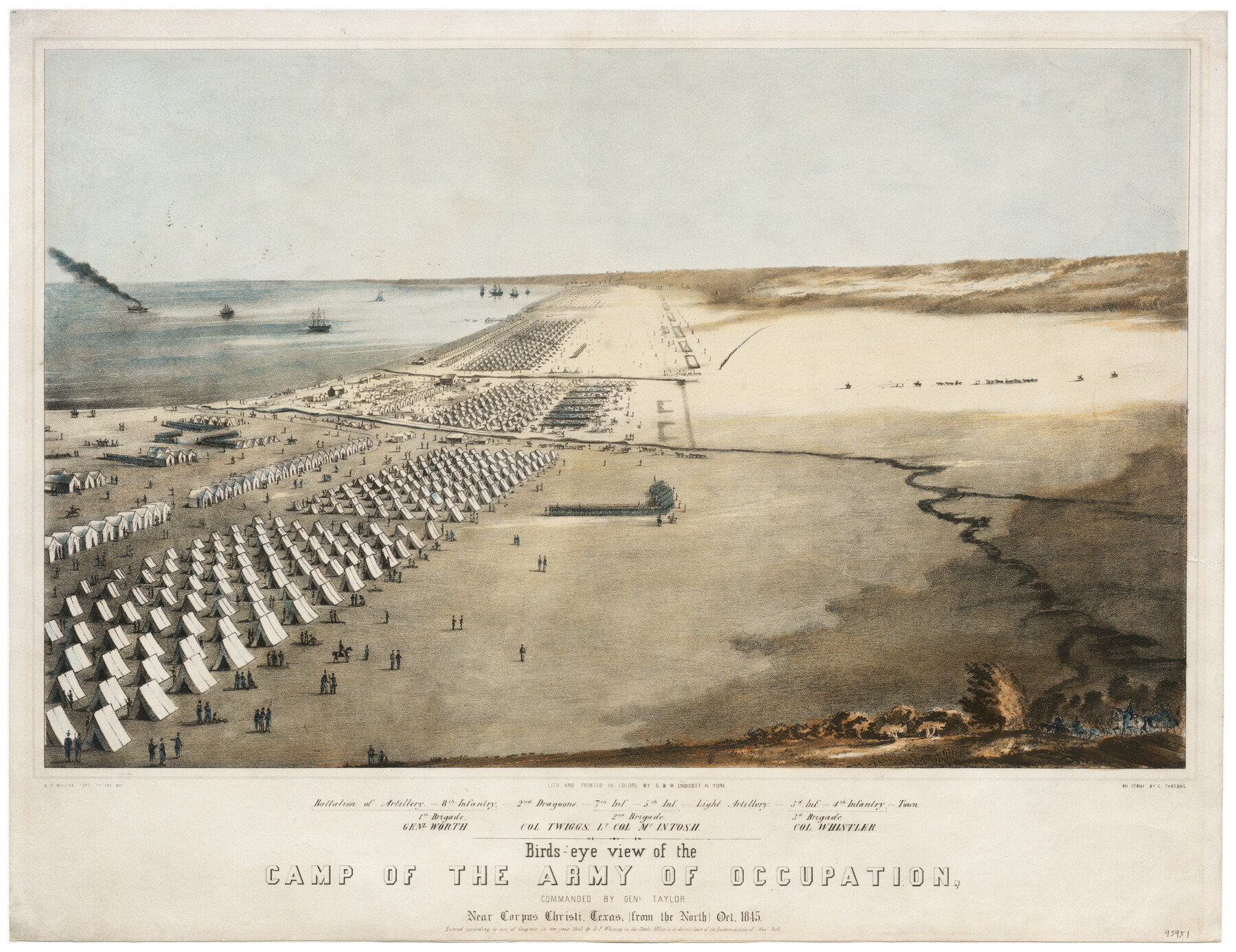
Birds-eye view of the camp of the army of occupation commanded by Genl. Taylor near Corpus Christi, Texas (from the North)
-
Map/Doc
95951
-
Collection
General Map Collection
-
Object Dates
1847 (Creation Date)
-
People and Organizations
G. & W. Endicott (Printer)
D.P. Whiting (Cartographer)
C. Parsons (Lithographer)
-
Subjects
Bird's Eye View Military
-
Height x Width
15.8 x 20.5 inches
40.1 x 52.1 cm
-
Medium
paper, etching/engraving/lithograph
Part of: General Map Collection
Kimble County Sketch File L1

Print $22.00
- Digital $50.00
Kimble County Sketch File L1
Size 7.1 x 13.1 inches
Map/Doc 28967
Map of section no. 7 of a survey of Padre Island made for the Office of the Attorney General of the State of Texas

Print $40.00
- Digital $50.00
Map of section no. 7 of a survey of Padre Island made for the Office of the Attorney General of the State of Texas
1941
Size 56.3 x 41.2 inches
Map/Doc 2263
Gregg County Working Sketch 20

Print $20.00
- Digital $50.00
Gregg County Working Sketch 20
1962
Size 34.3 x 44.4 inches
Map/Doc 63287
San Jacinto County Rolled Sketch 8

Print $20.00
- Digital $50.00
San Jacinto County Rolled Sketch 8
1940
Size 33.6 x 35.1 inches
Map/Doc 7559
Fort Bend County Working Sketch 9

Print $20.00
- Digital $50.00
Fort Bend County Working Sketch 9
1932
Size 38.7 x 16.0 inches
Map/Doc 69215
Flight Mission No. DQO-8K, Frame 15, Galveston County

Print $20.00
- Digital $50.00
Flight Mission No. DQO-8K, Frame 15, Galveston County
1952
Size 18.7 x 22.4 inches
Map/Doc 85138
Palo Pinto County Boundary File 4b

Print $38.00
- Digital $50.00
Palo Pinto County Boundary File 4b
Size 13.6 x 8.6 inches
Map/Doc 57824

Edwards County Working Sketch 134

Print $40.00
- Digital $50.00
Edwards County Working Sketch 134
1986
Size 29.4 x 54.2 inches
Map/Doc 69010
Travis County State Real Property Sketch 5

Print $20.00
- Digital $50.00
Travis County State Real Property Sketch 5
1990
Size 25.4 x 37.5 inches
Map/Doc 61696
Van Zandt County Sketch File 34

Print $4.00
- Digital $50.00
Van Zandt County Sketch File 34
1861
Size 7.8 x 15.0 inches
Map/Doc 39472
You may also like
[Surveys East of river copied from U.S. map of Township No. 6 South, Range No. 9 West of the Indian Meridian, Oklahoma]
![75186, [Surveys East of river copied from U.S. map of Township No. 6 South, Range No. 9 West of the Indian Meridian, Oklahoma], General Map Collection](https://historictexasmaps.com/wmedia_w700/maps/75186.tif.jpg)
Print $2.00
- Digital $50.00
[Surveys East of river copied from U.S. map of Township No. 6 South, Range No. 9 West of the Indian Meridian, Oklahoma]
Size 13.3 x 9.2 inches
Map/Doc 75186
Val Verde County Working Sketch 14

Print $20.00
- Digital $50.00
Val Verde County Working Sketch 14
1926
Size 17.2 x 18.9 inches
Map/Doc 72149
Brazoria County Sketch File 58

Print $30.00
- Digital $50.00
Brazoria County Sketch File 58
1992
Size 11.5 x 9.0 inches
Map/Doc 15382
Bexar County Sketch File 31

Print $40.00
- Digital $50.00
Bexar County Sketch File 31
1867
Size 11.3 x 16.4 inches
Map/Doc 10920
Starr County Sketch File 30A

Print $20.00
- Digital $50.00
Starr County Sketch File 30A
1935
Size 21.2 x 23.6 inches
Map/Doc 12334
Aransas County Boundary File 2

Print $3.00
- Digital $50.00
Aransas County Boundary File 2
Size 12.4 x 10.8 inches
Map/Doc 49781
San Patricio County Rolled Sketch 32

Print $20.00
- Digital $50.00
San Patricio County Rolled Sketch 32
1948
Size 38.8 x 25.0 inches
Map/Doc 7583
Edwards County Rolled Sketch 26

Print $20.00
- Digital $50.00
Edwards County Rolled Sketch 26
1958
Size 25.0 x 17.5 inches
Map/Doc 5812
Lampasas County Sketch File 16 1/2

Print $4.00
- Digital $50.00
Lampasas County Sketch File 16 1/2
Size 8.4 x 8.6 inches
Map/Doc 29428
Map of Kerr County

Print $20.00
- Digital $50.00
Map of Kerr County
1869
Size 22.2 x 32.1 inches
Map/Doc 3764
Galveston County Working Sketch 21

Print $20.00
- Digital $50.00
Galveston County Working Sketch 21
1987
Size 28.9 x 23.9 inches
Map/Doc 69358
Harris County Working Sketch 119

Print $20.00
- Digital $50.00
Harris County Working Sketch 119
1984
Size 30.8 x 42.2 inches
Map/Doc 66011